Coorparoo QLD 4151
12,060 addresses · 197 streets
Griffith Electorate › Brisbane LGA › Coorparoo · 5 km from Brisbane
📦 Thinking of moving here? Read the Coorparoo moving guide

Living Here
An established inner-southern Brisbane suburb with period homes and new apartments, Coorparoo is leafy and well-connected. Households average 2.3 people and the median age is 35. Median household income is $2,105 a week, with rent around $380.
Coorparoo is a suburb of Queensland, home to about 18,132 people, with a median age of 35. The typical household earns around $2,105 a week, with median rent near $380 a week. Most homes are apartments. About 53% of households own their home and 45% rent. Most workers drive to work. Common community backgrounds include English, Australian, Irish. On the ABS socio-economic scale it sits in decile 10 of 10 nationally — a relatively advantaged area.
Over time — Census 2001 → 2021
Dashed line: district figures for the Coorparoo statistical area (SA2), the smallest area the ABS published before 2011. Solid line: Coorparoo itself.
Getting Around & Local Services
25 hospitals
17 childcare & kindergartens
- Harty Street Kindergarten C&K
- Harmony Early Learning Coorparoo
- Goodstart Early Learning Coorparoo
- Timber Tots Child Care
- Koala Lou
- Harmony Early Learning Journey
- Outside School Care Association (OSCA)
- Busy Bees Early Learning Woolloongabba East
- Stones Corner Community Kindergarten
- Avenues Early Learning Centre
Getting around. Train station: Coorparoo, 1 km north-west · Bus interchange: Langlands Park, 1 km west · Ferry wharf: Mowbray Park ferry terminal, 2.8 km north-west · Airport: Brisbane Airport, 14.5 km north-east.
Socio-economic Standing
Deciles from 1 (lowest) to 10 (highest), against all Australian suburbs. The overall figure weighs advantage and disadvantage together; economic resources counts income and housing, and education & jobs counts qualifications and occupation. They often differ. Source: ABS SEIFA 2021.
Tree cover
🌳 Tree canopy: 16.5% share of land under canopy · satellite map, 2020
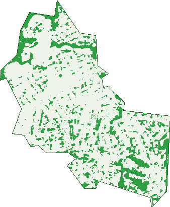
Green: 10 m cells where trees dominate, satellite 2021. Blue: water. The line is the suburb boundary.
| Canopy share, 1 m canopy height map, 2020 | 16.5% |
|---|---|
| Land with trees, 10 m satellite map, 2021 | 14.7% |
Demographics
Unemployment 3.8% · Labour-force participation 73.9%
Population by age in Coorparoo
| 0-4 | 902 |
|---|---|
| 5-14 | 1,783 |
| 15-19 | 936 |
| 20-24 | 1,570 |
| 25-34 | 3,661 |
| 35-44 | 2,882 |
| 45-54 | 2,399 |
| 55-64 | 1,743 |
| 65-74 | 1,146 |
| 75-84 | 700 |
| 85+ | 411 |
Dwelling types in Coorparoo
| House | 3,109 |
|---|---|
| Townhouse | 714 |
| Apartment | 3,825 |
| Other | 4 |
Households by weekly income in Coorparoo
| <$650 | 851 |
|---|---|
| $650-1,499 | 1,699 |
| $1,500-2,999 | 2,453 |
| $3,000+ | 2,342 |
Top ancestries in Coorparoo
| English | 6,501 |
|---|---|
| Australian | 5,528 |
| Irish | 3,166 |
| Other | 2,616 |
| Scottish | 2,225 |
| German | 1,021 |
Housing tenure in Coorparoo
| Owned | 1,650 |
|---|---|
| Mortgage | 2,365 |
| Rented | 3,417 |
| Other | 160 |
Cars per household in Coorparoo
| 0 | 676 |
|---|---|
| 1 | 3,443 |
| 2 | 2,518 |
| 3 | 648 |
| 4+ | 302 |
Commute to work in Coorparoo
| Car | 5,334 |
|---|---|
| Train | 187 |
| Bus | 855 |
| Tram/ferry | 7 |
| Walked | 224 |
| Bicycle | 177 |
| Home | 2,498 |
Top countries of birth in Coorparoo
| England | 529 |
|---|---|
| New Zealand | 468 |
| India | 457 |
| Nepal | 309 |
| Philippines | 163 |
| China | 152 |
Languages used at home in Coorparoo
| Nepali | 300 |
|---|---|
| Spanish | 243 |
| Mandarin | 224 |
| Greek | 165 |
| Hindi | 149 |
| Punjabi | 144 |
Birds & Wildlife Nearby
260,934 bird observations recorded near Coorparoo — most often seen:
- Noisy Miner (23,201)
- Torresian Crow (21,096)
- Rainbow Lorikeet (19,346)
- Australian White Ibis (13,147)
- Pied Currawong (12,963)
- Grey Butcherbird (12,561)
- Welcome Swallow (12,273)
- Australian Magpie (10,782)
- Australian Brush-turkey (9,718)
- Magpie-lark (9,399)
- Laughing Kookaburra (9,362)
- Pied Butcherbird (9,011)
- Scaly-breasted Lorikeet (8,990)
Show all 30 birds recorded near Coorparoo
- Dusky Moorhen (8,666)
- Australasian Figbird (8,435)
- Pacific Black Duck (6,355)
- Willie Wagtail (5,709)
- Masked Lapwing (5,445)
- Australian Wood Duck (5,355)
- Striated Pardalote (5,235)
- Rock Dove (4,728)
- Spotted Turtle-dove (4,629)
- Blue-faced Honeyeater (4,581)
- Crested Pigeon (4,564)
- Bush Stone-curlew (4,427)
- Tawny Frogmouth (4,388)
- Black-faced Cuckoo-shrike (4,223)
- Australasian Darter (4,211)
- Common Myna (4,193)
- Little Corella (3,941)
Sightings reported by observers, not a survey, so the counts show what people record rather than what lives here. Source: Atlas of Living Australia.
Nearby Suburbs
The closest suburbs to Coorparoo:
- Stones Corner (1.4 km)
- Greenslopes (1.6 km)
- Camp Hill (1.7 km)
- East Brisbane (2.2 km)
- Norman Park (2.2 km)
- Woolloongabba (2.3 km)
- Holland Park (2.5 km)
- Seven Hills (2.5 km)
Embed this suburb
Add this free Coorparoo stat card to your own site — just copy the code:
Preview:
Cite this page
Quoting these figures? Copy the credit line:
Keep an eye on Coorparoo
One email when this data meaningfully changes — new census figures, prices, rankings. No spam, unsubscribe anytime.
Streets
- Abbotsleigh Street (1)
- Amelia Street (151)
- Ames Street (14)
- Arc Street (21)
- Arlington Street (20)
- Armuna Street (1)
- Arvon Street (2)
- Baragoola Street (73)
- Barnes Avenue (48)
- Bath Street (1)
- Beet Street (24)
- Bennetts Road (1)
- Beresford Terrace (44)
- Biran Street (24)
- Birdwood Street (71)
- Birubi Street (38)
- Boongall Road (1)
- Boundary Road (9)
- Brae Street (71)
- Buena Vista Avenue (94)
- Burke Street (62)
- Cambridge Street (74)
- Canopus Street (62)
- Capella Street (81)
- Castlemaine Street (16)
- Castor Avenue (9)
- Caswell Street (1)
- Cavendish Road (1,211)
- Chatsworth Road (190)
- Chorlton Street (1)
- Churchill Street (8)
- Clarence Street (54)
- Condor Road (17)
- Cornwall Street (3)
- Crucis Street (27)
- Dale Street (25)
- Derby Street (166)
- Deshon Street (1)
- Doria Street (6)
- Douglas Street (1)
- Dowar Street (40)
- Doyle Street (13)
- Duhig Avenue (25)
- Durham Street (129)
- Eastleigh Lane (2)
- Eastwell Street (5)
- Edmond Street (17)
- Eighth Avenue (109)
- Emlyn Street (21)
- Esmonde Place (16)
- Eva Street (46)
- Ferol Street (53)
- Ferris Street (6)
- Fifth Avenue (53)
- Follington Crescent (2)
- Fork Street (21)
- French Street (90)
- Geelong Avenue (1)
- Geera Street (34)
- Gladstone Lane (12)
- Gladstone Street (74)
- Glen Street (14)
- Glyn Street (9)
- Goring Street (3)
- Greens Road (72)
- Gristock Street (29)
- Haig Street (176)
- Halifax Street (10)
- Halstead Street (93)
- Harries Road (325)
- Harty Street (31)
- Harwill Street (13)
- Hethorn Street (18)
- Hillock Street (33)
- Hipwood Avenue (62)
- Holdsworth Street (142)
- Howard Street (11)
- Illidge Street (61)
- Jackman Street (9)
- Jackson Street (26)
- Jellicoe Street (162)
- Jerome Street (30)
- Joffre Street (88)
- Kanumbra Street (31)
- Keera Street (19)
- Kelsey Street (41)
- Kenneth Street (24)
- Kent Street (57)
- Kirkland Avenue (292)
- Kitchener Street (426)
- Lackey Avenue (37)
- Lade Street (86)
- Lancaster Street (71)
- Landsdowne Street (28)
- Lauren James Place (1)
- Lavington Street (8)
- Leicester Street (186)
- Leigh Street (26)
- Leonards Street (5)
- Letchworth Road (27)
- Lindsay Street (8)
- Lingard Street (8)
- Macaulay Street (165)
- Mackay Street (88)
- Main Avenue (88)
- Mansfield Street (165)
- Marian Street (44)
- Marriott Street (45)
- Mars Street (27)
- Mclay Street (163)
- Meridian Street (31)
- Meteor Street (11)
- Milsom Street (93)
- Milton Lane (7)
- Mona Street (16)
- Morley Street (26)
- Nelson Street (55)
- Newton Street (26)
- Nicklin Street (165)
- Ninth Avenue (124)
- Noela Street (41)
- Norfolk Street (87)
- Norman Street (28)
- Octantis Street (34)
- Old Cleveland Road (788)
- Orion Street (32)
- Park Street (53)
- Pelham Street (41)
- Pembroke Road (293)
- Perihelion Street (16)
- Pine Mountain Road (1)
- Pollux Avenue (9)
- Primmer Street (32)
- Procyon Street (21)
- Raby Road (88)
- Rees Avenue (39)
- Regal Street (5)
- Rialto Street (228)
- Riddings Street (24)
- Rigel Street (35)
- Ripon Street (7)
- Robinson Street (102)
- Rome Street (37)
- Rossmore Avenue (19)
- Rowland Street (12)
- Rowsley Street (1)
- Rugby Street (8)
- Rutland Street (180)
- Saint Leonards Street (103)
- Salisbury Street (15)
- Satellite Street (7)
- Scott Street (1)
- Sector Street (12)
- Seventh Avenue (22)
- Shakespeare Street (198)
- Shire Street (74)
- Sirius Street (87)
- Sixth Avenue (22)
- Smeaton Street (28)
- Solar Street (58)
- Spica Street (16)
- Springleigh Street (7)
- Stanley Street E (129)
- Stirrat Street (58)
- Stodart Street (11)
- Stoneleigh Street (10)
- Strangman Terrace (4)
- Talbot Street (64)
- Temple Street (153)
- Tenth Avenue (21)
- The Crescent (15)
- The Lane (1)
- The Laneway (1)
- Thomas Street (1)
- Tiber Street (36)
- Trundle Street (28)
- Turbo Drive (31)
- Upper Cornwall Street (56)
- Venice Street (21)
- Verry Street (26)
- View Street (17)
- Wakefield Street (22)
- Walker Street (32)
- Waverley Road (1)
- Wellington Street (173)
- Wellstead Avenue (29)
- Welwyn Crescent (30)
- West Street (9)
- Weston Street (161)
- White Avenue (20)
- Wills Street (42)
- Woodhill Avenue (82)
- Woodrow Drive (46)
- Wylie Avenue (52)
- Wylma Street (1)
- Yarrabin Street (8)
- York Street (128)