Camp Hill QLD 4152
6,028 addresses · 137 streets
Griffith Electorate › Brisbane LGA › Camp Hill · 6 km from Brisbane
📦 Thinking of moving here? Read the Camp Hill moving guide

Living Here
Camp Hill is a suburb of Queensland, home to about 12,254 people, with a median age of 35. The typical household earns around $3,085 a week, with median rent near $460 a week. Most homes are houses. About 71% of households own their home and 28% rent. Most workers drive to work. Common community backgrounds include English, Australian, Irish. On the ABS socio-economic scale it sits in decile 10 of 10 nationally — a relatively advantaged area.
Over time — Census 2001 → 2021
Dashed line: district figures for the Camp Hill statistical area (SA2), the smallest area the ABS published before 2011. Solid line: Camp Hill itself.
Getting Around & Local Services
25 hospitals
17 childcare & kindergartens
Getting around. Train station: Norman Park, 1.9 km north-west · Bus interchange: Langlands Park, 2.7 km west · Ferry wharf: New Farm Park ferry terminal, 3.4 km north-west · Airport: Brisbane Airport, 13.4 km north.
Socio-economic Standing
Deciles from 1 (lowest) to 10 (highest), against all Australian suburbs. The overall figure weighs advantage and disadvantage together; economic resources counts income and housing, and education & jobs counts qualifications and occupation. They often differ. Source: ABS SEIFA 2021.
Tree cover
🌳 Tree canopy: 23.3% share of land under canopy · satellite map, 2020
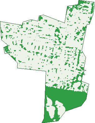
Green: 10 m cells where trees dominate, satellite 2021. Blue: water. The line is the suburb boundary.
| Canopy share, 1 m canopy height map, 2020 | 23.3% |
|---|---|
| Land with trees, 10 m satellite map, 2021 | 22.1% |
Demographics
Unemployment 3.3% · Labour-force participation 77.3%
Population by age in Camp Hill
| 0-4 | 885 |
|---|---|
| 5-14 | 1,832 |
| 15-19 | 805 |
| 20-24 | 814 |
| 25-34 | 1,605 |
| 35-44 | 2,047 |
| 45-54 | 2,021 |
| 55-64 | 1,142 |
| 65-74 | 647 |
| 75-84 | 305 |
| 85+ | 149 |
Dwelling types in Camp Hill
| House | 3,592 |
|---|---|
| Townhouse | 455 |
| Apartment | 203 |
| Other | 5 |
Households by weekly income in Camp Hill
| <$650 | 330 |
|---|---|
| $650-1,499 | 603 |
| $1,500-2,999 | 1,014 |
| $3,000+ | 2,080 |
Top ancestries in Camp Hill
| English | 4,885 |
|---|---|
| Australian | 4,422 |
| Irish | 2,103 |
| Scottish | 1,536 |
| Other | 1,153 |
| German | 750 |
Housing tenure in Camp Hill
| Owned | 1,123 |
|---|---|
| Mortgage | 1,879 |
| Rented | 1,193 |
| Other | 34 |
Cars per household in Camp Hill
| 0 | 160 |
|---|---|
| 1 | 1,314 |
| 2 | 1,950 |
| 3 | 539 |
| 4+ | 267 |
Commute to work in Camp Hill
| Car | 3,696 |
|---|---|
| Train | 44 |
| Bus | 382 |
| Tram/ferry | 6 |
| Walked | 72 |
| Bicycle | 64 |
| Home | 1,767 |
Top countries of birth in Camp Hill
| England | 357 |
|---|---|
| New Zealand | 334 |
| South Africa | 116 |
| India | 107 |
| Scotland | 72 |
| China | 67 |
Languages used at home in Camp Hill
| Mandarin | 138 |
|---|---|
| Greek | 135 |
| Spanish | 90 |
| Italian | 79 |
| Hindi | 74 |
| Vietnamese | 62 |
Birds & Wildlife Nearby
190,319 bird observations recorded near Camp Hill — most often seen:
- Noisy Miner (12,972)
- Torresian Crow (12,759)
- Rainbow Lorikeet (11,670)
- Welcome Swallow (8,673)
- Magpie-lark (8,664)
- Australian White Ibis (8,610)
- Dusky Moorhen (8,181)
- Grey Butcherbird (7,817)
- Pacific Black Duck (7,781)
- Australian Magpie (7,041)
- Pied Butcherbird (6,878)
- Laughing Kookaburra (6,810)
- Australasian Figbird (6,612)
Show all 30 birds recorded near Camp Hill
- Willie Wagtail (6,380)
- Crested Pigeon (5,270)
- Brown Honeyeater (5,235)
- Australian Wood Duck (5,129)
- Australasian Purple Swamphen (5,057)
- Scaly-breasted Lorikeet (4,823)
- Black-faced Cuckoo-shrike (4,669)
- Common Myna (4,443)
- Little Black Cormorant (4,321)
- Pied Currawong (4,096)
- Spotted Turtle-dove (4,064)
- Striated Pardalote (4,052)
- Rock Dove (4,000)
- Intermediate Egret (3,745)
- Little Pied Cormorant (3,731)
- Australasian Grebe (3,432)
- Blue-faced Honeyeater (3,404)
Sightings reported by observers, not a survey, so the counts show what people record rather than what lives here. Source: Atlas of Living Australia.
Nearby Suburbs
The closest suburbs to Camp Hill:
- Seven Hills (1.5 km)
- Coorparoo (1.7 km)
- Carina Heights (1.9 km)
- Carina (2.1 km)
- Norman Park (2.2 km)
- Holland Park (2.9 km)
- Morningside (2.9 km)
- Stones Corner (3.1 km)
Embed this suburb
Add this free Camp Hill stat card to your own site — just copy the code:
Preview:
Cite this page
Quoting these figures? Copy the credit line:
Keep an eye on Camp Hill
One email when this data meaningfully changes — new census figures, prices, rankings. No spam, unsubscribe anytime.
Streets
- Abbott Street (22)
- Agate Street (23)
- Akala Street (44)
- Albert Street (100)
- Annie Street (42)
- Ara Street (62)
- Arrol Street (68)
- Arrowsmith Street (40)
- Ascham Street (5)
- Ashmole Street (4)
- Ashton Street (102)
- Aubrey Street (15)
- Audrey Street (21)
- Baden Powell Place (4)
- Bennetts Road (94)
- Biran Street (22)
- Booligal Street (2)
- Boongall Road (64)
- Boundary Road (124)
- Bovelles Street (79)
- Brinawa Street (67)
- Brisbane Avenue (64)
- Brooks Street (47)
- Brown Street (60)
- Bruce Street (15)
- Bundah Street (82)
- Burn Street (91)
- Camboor Street (29)
- Cambridge Street (4)
- Carranya Street (70)
- Cedlen Street (15)
- Citrine Street (17)
- City View Road (80)
- Clara Street (51)
- Coke Street (6)
- Combles Road (40)
- Cyril Street (37)
- D'arcy Road (14)
- Daly Street (19)
- Daphne Street (12)
- Donald Street (86)
- Dorothy Lane (16)
- Dorothy Street (18)
- Durimbil Street (38)
- East Street (98)
- Edencourt Street (22)
- Eleanor Street (7)
- Ernest Street (37)
- Errey Street (20)
- Ethel Street (14)
- Faraday Street (16)
- Ferguson Road (40)
- First Street (37)
- Fred Street (10)
- Fryar Street (38)
- Glanosmond Avenue (22)
- Gotha Street (32)
- Grant Street (27)
- Halland Terrace (90)
- Halstead Street (3)
- Hamel Street (30)
- Hartley Street (34)
- Henderson Street (79)
- Herbert Street (29)
- Hobart Avenue (44)
- Houthem Street (33)
- Indus Street (120)
- Jackson Street (2)
- Jade Street (5)
- Janette Street (10)
- Jones Road (2)
- Joseph Street (18)
- Judge Street (1)
- Kelsey Street (2)
- Kennington Road (142)
- Kismet Street (14)
- Koolatah Street (6)
- Koondara Street (29)
- Lavington Street (6)
- Leepers Lane (6)
- Leicester Street (5)
- Lewis Street (64)
- Lloyd Street (96)
- Lockyer Street (39)
- Long Street (75)
- Lossock Avenue (5)
- Madeline Street (5)
- Mantilla Street (3)
- Margaret Street (42)
- Martha Street (107)
- Martock Street (15)
- Mcilwraith Avenue (2)
- Melbourne Avenue (56)
- Milne Lane (1)
- Morven Street (12)
- Nellie Street (32)
- Nestor Lane (1)
- Newman Avenue (136)
- Noble Street (22)
- Nurstead Street (40)
- Obsidian Street (14)
- Old Cleveland Road (338)
- Orwell Street (23)
- Pampling Street (38)
- Parooba Avenue (63)
- Patrick Lane (2)
- Pavo Street (54)
- Perth Street (65)
- Pinecroft Street (33)
- Pitney Street (10)
- Princess Street (66)
- Prout Street (45)
- Pryde Street (25)
- Pyrope Street (13)
- Quebec Avenue (20)
- Raven Street (87)
- Renton Street (98)
- Samuel Street (100)
- Snell Street (7)
- Spinel Street (12)
- Stanley Road (86)
- Stephen Street (93)
- Sydney Avenue (71)
- Sylvia Street (34)
- Tarana Street (113)
- Temple Street (1)
- The Promenade (88)
- Third Street (43)
- Thomas Street (76)
- Tranters Avenue (65)
- Warilda Street (78)
- Watson Street (155)
- Waverley Road (121)
- Wiles Street (7)
- Wotton Street (25)
- Wruck Avenue (4)
- Wyena Street (57)