Elderslie NSW 2570
3,501 addresses · 133 streets
Hume Electorate › Camden LGA › Elderslie · 50 km from Sydney
📦 Thinking of moving here? Read the Elderslie moving guide

Living Here
Elderslie is a suburb of New South Wales, home to about 7,878 people, with a median age of 34. The typical household earns around $2,150 a week, with median rent near $480 a week. Most homes are houses. About 69% of households own their home and 29% rent. Most workers drive to work. Common community backgrounds include Australian, English, Scottish. On the ABS socio-economic scale it sits in decile 8 of 10 nationally — a relatively advantaged area.
Over time — Census 2001 → 2021
Dashed line: district figures for the Elderslie - Harrington Park statistical area (SA2), the smallest area the ABS published before 2011. Solid line: Elderslie itself.
Getting Around & Local Services
6 supermarkets
3 Catholic churches
4 doctors & medical clinics
2 dentists
2 vets
2 childcare & kindergartens
2 libraries
2 post offices
2 dog parks
2 bakeries
5 hardware stores
1 hairdresser
1 plumber
3 places to stay
Getting around. Train station: Menangle Park, 5.7 km south-east · Airport: Camden Airport, 3.5 km north-west.
Socio-economic Standing
Deciles from 1 (lowest) to 10 (highest), against all Australian suburbs. The overall figure weighs advantage and disadvantage together; economic resources counts income and housing, and education & jobs counts qualifications and occupation. They often differ. Source: ABS SEIFA 2021.
Tree cover
🌳 Tree canopy: 7.7% share of land under canopy · satellite map, 2020
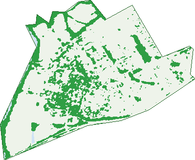
Green: 10 m cells where trees dominate, satellite 2021. Blue: water. The line is the suburb boundary.
| Canopy share, 1 m canopy height map, 2020 | 7.7% |
|---|---|
| Surveyed canopy, Greater Sydney aerial survey, 2019 | 9.7% |
| Land with trees, 10 m satellite map, 2021 | 24.6% |
Demographics
Unemployment 3.1% · Labour-force participation 68.6%
Population by age in Elderslie
| 0-4 | 696 |
|---|---|
| 5-14 | 1,239 |
| 15-19 | 543 |
| 20-24 | 444 |
| 25-34 | 1,114 |
| 35-44 | 1,150 |
| 45-54 | 922 |
| 55-64 | 740 |
| 65-74 | 601 |
| 75-84 | 336 |
| 85+ | 96 |
Dwelling types in Elderslie
| House | 2,339 |
|---|---|
| Townhouse | 286 |
| Apartment | 42 |
| Other | 56 |
Households by weekly income in Elderslie
| <$650 | 353 |
|---|---|
| $650-1,499 | 559 |
| $1,500-2,999 | 877 |
| $3,000+ | 791 |
Top ancestries in Elderslie
| Australian | 3,247 |
|---|---|
| English | 3,232 |
| Scottish | 842 |
| Irish | 831 |
| Other | 747 |
| Italian | 434 |
Housing tenure in Elderslie
| Owned | 619 |
|---|---|
| Mortgage | 1,249 |
| Rented | 788 |
| Other | 39 |
Cars per household in Elderslie
| 0 | 119 |
|---|---|
| 1 | 799 |
| 2 | 1,159 |
| 3 | 388 |
| 4+ | 222 |
Commute to work in Elderslie
| Car | 2,082 |
|---|---|
| Train | 13 |
| Bus | 7 |
| Tram/ferry | 0 |
| Walked | 24 |
| Bicycle | 6 |
| Home | 1,089 |
Top countries of birth in Elderslie
| England | 270 |
|---|---|
| New Zealand | 92 |
| Scotland | 53 |
| India | 47 |
| Philippines | 44 |
| Italy | 31 |
Languages used at home in Elderslie
| Spanish | 85 |
|---|---|
| Italian | 48 |
| Mandarin | 35 |
| Arabic | 33 |
| Hindi | 30 |
| Serbian | 25 |
Birds & Wildlife Nearby
116,302 bird observations recorded near Elderslie — most often seen:
- Noisy Miner (5,888)
- Australian Raven (5,457)
- Rainbow Lorikeet (5,377)
- Common Myna (4,996)
- Bell Miner (4,853)
- Magpie-lark (4,850)
- Australian Wood Duck (4,795)
- Superb Fairy-wren (4,689)
- Sulphur-crested Cockatoo (4,583)
- Australian White Ibis (4,452)
- Australian Magpie (4,277)
- Pacific Black Duck (4,170)
- Dusky Moorhen (4,050)
Show all 30 birds recorded near Elderslie
- Eastern Rosella (4,009)
- Willie Wagtail (3,985)
- Grey Butcherbird (3,825)
- Australasian Purple Swamphen (3,727)
- Eurasian Coot (3,652)
- Australasian Grebe (3,364)
- Crested Pigeon (3,333)
- Welcome Swallow (3,095)
- Silvereye (3,091)
- Pied Currawong (2,886)
- Galah (2,853)
- Red-rumped Parrot (2,815)
- Little Pied Cormorant (2,716)
- White-faced Heron (2,651)
- Satin Bowerbird (2,635)
- Red-browed Finch (2,618)
- Masked Lapwing (2,610)
Sightings reported by observers, not a survey, so the counts show what people record rather than what lives here. Source: Atlas of Living Australia.
Nearby Suburbs
The closest suburbs to Elderslie:
- Spring Farm (1.5 km)
- Narellan (2 km)
- Camden (2.3 km)
- Narellan Vale (2.3 km)
- Kirkham (3 km)
- Mount Annan (3.5 km)
- Camden South (3.7 km)
- Harrington Park (3.8 km)
Embed this suburb
Add this free Elderslie stat card to your own site — just copy the code:
Preview:
Cite this page
Quoting these figures? Copy the credit line:
Keep an eye on Elderslie
One email when this data meaningfully changes — new census figures, prices, rankings. No spam, unsubscribe anytime.
Streets
- Acorn Grove (9)
- Adams Circuit (57)
- Anvil Avenue (31)
- Asimus Circuit (46)
- Auld Street (5)
- Baker Way (6)
- Bates Close (18)
- Bengal Crescent (35)
- Border Close (15)
- Bouddi Parkway (38)
- Bowerman Road (36)
- Brennan Road (51)
- Britton Close (7)
- Brooking Avenue (40)
- Bruchhauser Crescent (25)
- Brunero Street (13)
- Burrawong Crescent (58)
- Camden Acres Drive (32)
- Camden Valley Way (22)
- Carpenter Street (24)
- Carus Lane (2)
- Cashmere Drive (26)
- Casimer Avenue (26)
- Cattai Ridge (26)
- Charlotte Place (5)
- Church Street (14)
- Clissold Street (18)
- Clowes Street (40)
- Condron Circuit (28)
- Conjola Place (8)
- Coopworth Road (10)
- Cormo Close (27)
- Corriedale Close (7)
- Corven Avenue (28)
- Cowell Lane (6)
- Cox Street (4)
- Crank Place (13)
- Cruikshank Avenue (33)
- Dann Lane (1)
- Dengate Close (23)
- Dormer Close (16)
- Drysdale Road (57)
- Elliotdale Close (13)
- Faithfull Street (10)
- Feld Avenue (5)
- Fletcher Close (7)
- Folkes Street (52)
- Franzman Avenue (48)
- Galvin Street (8)
- Gardiner Crescent (17)
- Garigal Way (20)
- Geary Place (4)
- Gilbert Street (7)
- Gracie Road (22)
- Greenfield Crescent (53)
- Grimes Avenue (35)
- Guardian Place (10)
- Gunn Way (13)
- Harrington Street (81)
- Hassall Street (1)
- Hassell Street (1)
- Hawdon Close (29)
- Higgins Avenue (73)
- Hilder Street (55)
- Hynes Place (33)
- Irvine Lane (8)
- Irvine Street (68)
- Jackson Crescent (23)
- Justinian Drive (35)
- Kanangra Crescent (14)
- Kerrigan Crescent (92)
- Kingsman Avenue (41)
- Knight Street (12)
- Kowald Street (26)
- Lamb Place (6)
- Larnach Place (23)
- Lindsey Place (19)
- Liz Kernohan Drive (126)
- Lodges Road (138)
- Longley Avenue (58)
- Lorimer Crescent (58)
- Lowe Crescent (16)
- Luker Street (31)
- Lyons Street (6)
- Macarthur Road (192)
- Marsden Avenue (18)
- Mcleod Place (6)
- Mclucas Circuit (20)
- Merino Drive (62)
- Merriman Close (15)
- Metis Lane (2)
- Mitten Street (10)
- Nethery Avenue (1)
- Nettleton Street (23)
- Osbourne Street (18)
- Palmer Street (5)
- Parker Street (3)
- Parrott Street (18)
- Penrhyn Crescent (34)
- Peppin Place (12)
- Percival Road (4)
- Polworth Close (12)
- Preston Avenue (7)
- Purcell Street (43)
- Reilly Road (26)
- Rheinbergers Circuit (42)
- River Road (42)
- Romney Street (54)
- Ryeland Close (6)
- Shearer Place (8)
- Silky Oak Grove (6)
- Sirius Circuit (18)
- Sophia Street (10)
- Southdown Road (108)
- Stone Lane (16)
- Suffolk Place (18)
- Sunset Avenue (20)
- Teasdale Close (17)
- Templeton Road (19)
- Thornton Lane (1)
- Thornton Road (13)
- Thurn Place (15)
- Trotter Street (11)
- Tukidale Close (10)
- Vicary Avenue (20)
- Weirberly Road (12)
- Wells Lane (3)
- Whyte Place (13)
- Wierberly Road (3)
- Wilkinson Street (17)
- Woolpack Street (23)
- Yengo Avenue (24)
- Young Circuit (38)