Harrington Park NSW 2567
4,359 addresses · 177 streets
Macarthur Electorate › Camden LGA › Harrington Park · 47 km from Sydney
📦 Thinking of moving here? Read the Harrington Park moving guide

Living Here
Harrington Park is a suburb of New South Wales, home to about 13,332 people, with a median age of 35. The typical household earns around $3,014 a week, with median rent near $550 a week. Most homes are houses. About 86% of households own their home and 13% rent. Most workers drive to work. Common community backgrounds include Australian, English, Italian. On the ABS socio-economic scale it sits in decile 10 of 10 nationally — a relatively advantaged area.
Over time — Census 2001 → 2021
Dashed line: district figures for the Elderslie - Harrington Park statistical area (SA2), the smallest area the ABS published before 2011. Solid line: Harrington Park itself.
Getting Around & Local Services
4 supermarkets
1 medical clinic
2 dentists
1 vet
3 libraries
5 hardware stores
4 mechanics
1 electrician
1 plumber
3 places to stay
Getting around. Train station: Macarthur, 7.5 km south-east · Airport: Camden Airport, 4.9 km west.
Socio-economic Standing
Deciles from 1 (lowest) to 10 (highest), against all Australian suburbs. The overall figure weighs advantage and disadvantage together; economic resources counts income and housing, and education & jobs counts qualifications and occupation. They often differ. Source: ABS SEIFA 2021.
Tree cover
🌳 Tree canopy: 20.4% share of land under canopy · satellite map, 2020
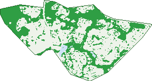
Green: 10 m cells where trees dominate, satellite 2021. Blue: water. The line is the suburb boundary.
| Canopy share, 1 m canopy height map, 2020 | 20.4% |
|---|---|
| Surveyed canopy, Greater Sydney aerial survey, 2019 | 12.8% |
| Land with trees, 10 m satellite map, 2021 | 38.5% |
Demographics
Unemployment 2.7% · Labour-force participation 71.3%
Population by age in Harrington Park
| 0-4 | 872 |
|---|---|
| 5-14 | 2,386 |
| 15-19 | 1,158 |
| 20-24 | 916 |
| 25-34 | 1,209 |
| 35-44 | 2,057 |
| 45-54 | 2,287 |
| 55-64 | 1,283 |
| 65-74 | 752 |
| 75-84 | 337 |
| 85+ | 71 |
Dwelling types in Harrington Park
| House | 3,698 |
|---|---|
| Townhouse | 64 |
| Apartment | 13 |
| Other | 0 |
Households by weekly income in Harrington Park
| <$650 | 220 |
|---|---|
| $650-1,499 | 545 |
| $1,500-2,999 | 1,006 |
| $3,000+ | 1,795 |
Top ancestries in Harrington Park
| Australian | 4,342 |
|---|---|
| English | 3,986 |
| Other | 1,985 |
| Italian | 1,442 |
| Irish | 1,084 |
| Scottish | 894 |
Housing tenure in Harrington Park
| Owned | 958 |
|---|---|
| Mortgage | 2,285 |
| Rented | 490 |
| Other | 19 |
Cars per household in Harrington Park
| 0 | 48 |
|---|---|
| 1 | 610 |
| 2 | 1,657 |
| 3 | 796 |
| 4+ | 633 |
Commute to work in Harrington Park
| Car | 3,413 |
|---|---|
| Train | 29 |
| Bus | 5 |
| Tram/ferry | 0 |
| Walked | 24 |
| Bicycle | 9 |
| Home | 2,276 |
Top countries of birth in Harrington Park
| England | 379 |
|---|---|
| India | 173 |
| New Zealand | 140 |
| Italy | 121 |
| China | 119 |
| South Africa | 107 |
Languages used at home in Harrington Park
| Arabic | 301 |
|---|---|
| Italian | 201 |
| Spanish | 198 |
| Mandarin | 158 |
| Croatian | 144 |
| Hindi | 119 |
Birds & Wildlife Nearby
50,203 bird observations recorded near Harrington Park — most often seen:
- Common Myna (2,855)
- Rainbow Lorikeet (2,458)
- Noisy Miner (2,424)
- Magpie-lark (2,348)
- Australian Raven (2,305)
- Dusky Moorhen (2,081)
- Pacific Black Duck (2,070)
- Australian White Ibis (2,032)
- Sulphur-crested Cockatoo (2,024)
- Australian Wood Duck (2,019)
- Willie Wagtail (1,988)
- Australasian Purple Swamphen (1,918)
- Superb Fairy-wren (1,818)
Show all 30 birds recorded near Harrington Park
- Eurasian Coot (1,761)
- Grey Butcherbird (1,740)
- Australian Magpie (1,581)
- Galah (1,513)
- Welcome Swallow (1,468)
- Spotted Turtle-dove (1,450)
- Australasian Grebe (1,383)
- Little Pied Cormorant (1,379)
- Crested Pigeon (1,340)
- Eastern Rosella (1,334)
- Red-rumped Parrot (1,235)
- Little Corella (997)
- White-faced Heron (989)
- Masked Lapwing (953)
- Pied Currawong (935)
- Yellow Thornbill (915)
- Australian Reed Warbler (890)
Sightings reported by observers, not a survey, so the counts show what people record rather than what lives here. Source: Atlas of Living Australia.
Nearby Suburbs
The closest suburbs to Harrington Park:
- Narellan (2.1 km)
- Smeaton Grange (2.2 km)
- Oran Park (2.5 km)
- Kirkham (2.6 km)
- Narellan Vale (3.1 km)
- Cobbitty (3.3 km)
- Catherine Field (3.3 km)
- Gregory Hills (3.6 km)
Embed this suburb
Add this free Harrington Park stat card to your own site — just copy the code:
Preview:
Cite this page
Quoting these figures? Copy the credit line:
Keep an eye on Harrington Park
One email when this data meaningfully changes — new census figures, prices, rankings. No spam, unsubscribe anytime.
Streets
- Abercrombie Place (26)
- Albury Court (8)
- Alexandra Crescent (62)
- Arietta Circuit (23)
- Atterall Court (13)
- Bailey Court (3)
- Balmoral Terrace (6)
- Barford Way (18)
- Beechworth Parade (22)
- Benalla Cove (3)
- Bentella Road (6)
- Binda Way (29)
- Blaxcell Place (12)
- Blenheim Terrace (6)
- Bow Place (7)
- Boyd Court (25)
- Bradley Drive (80)
- Brady Place (30)
- Breza Way (4)
- Brookman Avenue (25)
- Bryant Place (5)
- Budbury Street (4)
- Budgen Circuit (23)
- Bull Place (9)
- Bundell Street (10)
- Caesar Place (20)
- Camden Valley Way (2)
- Cameron Circuit (45)
- Cape Banks Drive (22)
- Carabeely Place (14)
- Caroline Place (5)
- Castlemaine Circuit (60)
- Chamberlain Way (35)
- Charker Drive (42)
- Charters Avenue (10)
- Chatham Link (20)
- Chelsea Court (18)
- Chiltern Place (8)
- Clontarf Avenue (25)
- Cobbitty Road (3)
- Cogrington Drive (39)
- Collector Drive (41)
- Colt Court (7)
- Correllis Street (52)
- Crain Court (15)
- Crookwell Way (5)
- Cummins Loop (19)
- Daley Loop (15)
- Dalton Terrace (21)
- Dan Cleary Drive (2)
- Dargin Close (38)
- Darling Crescent (28)
- Davy Court (12)
- Denbigh Place (21)
- Denison Street (34)
- Dillon Court (6)
- Donahue Circuit (46)
- Doolan Crescent (37)
- Douglas Place (10)
- Dunlop Avenue (14)
- Ellen Ridge (6)
- Endeavour Circuit (58)
- Entwistle Crescent (22)
- Euroa Way (8)
- Fairwater Drive (107)
- Flintlock Drive (53)
- Foley Circuit (50)
- Forestgrove Drive (65)
- Foveaux Circuit (13)
- Gabitt Place (6)
- George Bransby Circuit (34)
- Giddings Link (6)
- Glenbrae Drive (8)
- Glenrowan Drive (78)
- Governor Drive (82)
- Greta Avenue (12)
- Gurgar Place (8)
- Halcyon Court (14)
- Hall Place (11)
- Hambledon Circuit (50)
- Harrington Parkway (21)
- Harrison Avenue (60)
- Hart Court (9)
- Hawthorne Circuit (51)
- Hayes Court (23)
- Heritage Retreat (8)
- Hewitt Link (14)
- Hibernia Place (11)
- Hickson Circuit (48)
- Hillside Drive (13)
- Homestead Court (7)
- Hope Street (35)
- Howe Circuit (13)
- Howe Street (13)
- Hughes Avenue (52)
- Inglis Court (8)
- James Bailey Drive (33)
- James Flynn Avenue (11)
- Jenolan Circuit (57)
- John Mclennon Circuit (37)
- Justis Drive (49)
- Kate Terrace (9)
- Kensington Drive (47)
- Keys Place (6)
- Kinnear Street (54)
- Lachlan Avenue (42)
- Lakeland Circuit (52)
- Layton Court (5)
- Lincoln Grove (26)
- Lockhart Court (25)
- Longarm Place (18)
- Lonigan Parade (24)
- Lord Eldon Drive (23)
- Lowry Close (13)
- Macleay Court (24)
- Mannix Court (17)
- Mare Court (8)
- Mason Drive (66)
- Mccallum Link (10)
- Meehan Terrace (54)
- Melville Court (4)
- Midnite Court (6)
- Minell Court (40)
- Moonlite Court (8)
- Morton Terrace (51)
- Murdoch Court (11)
- Nolan Way (9)
- O'meally Place (22)
- Oatley Circuit (42)
- Olsen Place (20)
- Parson Place (16)
- Pearson Crescent (128)
- Peisley Court (12)
- Perry Court (6)
- Pigeon Place (4)
- Pincombe Crescent (16)
- Pippen Street (19)
- Redford Place (10)
- Regency Drive (21)
- Rhodes Place (19)
- Ribbon Court (7)
- Rigney Place (9)
- Rogan Close (6)
- Rosina Avenue (28)
- Royal George Drive (73)
- Rutherford Circuit (41)
- Salter Court (27)
- Scanlon Crescent (12)
- Sharman Close (38)
- Sherrit Way (14)
- Sir Warwick Fairfax Drive (63)
- Sorell Way (26)
- Starlight Retreat (19)
- Stein Road (4)
- Stewart Street (13)
- Swan Court (6)
- Tenterfield Way (6)
- The Boulevard (21)
- The Northern Road (8)
- Thorn Avenue (34)
- Tiffen Street (8)
- Towra Court (12)
- Turbott Avenue (72)
- Underwood Circuit (47)
- Uralla Close (8)
- Vane Close (9)
- Wayman Avenue (23)
- Wellington Drive (8)
- Westwood Court (14)
- Wheatley Place (11)
- Whitely Grove (8)
- Whitten Parade (55)
- William Campbell Avenue (55)
- Wingham Avenue (28)
- Wolloo Close (6)
- Woodgrove Avenue (35)
- Yellilong Place (4)