Oran Park NSW 2570
10,084 addresses · 315 streets
Macarthur Electorate › Camden LGA › Oran Park · 46 km from Sydney
📦 Thinking of moving here? Read the Oran Park moving guide

Living Here
A fast-growing master-planned suburb in Sydney's south-west, Oran Park is built around new family estates and a town centre. A young median age of 30 and large households of 3.3 people prevail; combined household income is high at $2,349 a week, with rent around $530.
Oran Park is a suburb of New South Wales, home to about 17,624 people, with a median age of 30. The typical household earns around $2,349 a week, with median rent near $530 a week. Most homes are houses. About 62% of households own their home and 36% rent. Most workers drive to work. Common community backgrounds include Australian, English, Indian. On the ABS socio-economic scale it sits in decile 9 of 10 nationally — a relatively advantaged area.
Over time — Census 2001 → 2021
Dashed line: district figures for the Cobbitty - Leppington statistical area (SA2), the smallest area the ABS published before 2011. Solid line: Oran Park itself.
Getting Around & Local Services
3 supermarkets
1 medical clinic
1 dentist
1 vet
2 childcare & kindergartens
2 libraries
1 post office
5 service stations
4 hardware stores
1 mechanic
1 electrician
1 plumber
1 place to stay
Getting around. Train station: Leppington, 8.3 km north-east · Airport: Camden Airport, 6.4 km south-west.
Socio-economic Standing
Deciles from 1 (lowest) to 10 (highest), against all Australian suburbs. The overall figure weighs advantage and disadvantage together; economic resources counts income and housing, and education & jobs counts qualifications and occupation. They often differ. Source: ABS SEIFA 2021.
Tree cover
🌳 Tree canopy: 2% share of land under canopy · satellite map, 2020
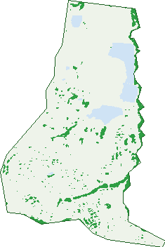
Green: 10 m cells where trees dominate, satellite 2021. Blue: water. The line is the suburb boundary.
| Canopy share, 1 m canopy height map, 2020 | 2.0% |
|---|---|
| Surveyed canopy, Greater Sydney aerial survey, 2019 | 2.2% |
| Land with trees, 10 m satellite map, 2021 | 7.1% |
Demographics
Unemployment 4.9% · Labour-force participation 70.2%
Population by age in Oran Park
| 0-4 | 2,198 |
|---|---|
| 5-14 | 3,080 |
| 15-19 | 940 |
| 20-24 | 995 |
| 25-34 | 3,618 |
| 35-44 | 3,357 |
| 45-54 | 1,566 |
| 55-64 | 944 |
| 65-74 | 622 |
| 75-84 | 227 |
| 85+ | 71 |
Dwelling types in Oran Park
| House | 4,485 |
|---|---|
| Townhouse | 603 |
| Apartment | 57 |
| Other | 0 |
Households by weekly income in Oran Park
| <$650 | 315 |
|---|---|
| $650-1,499 | 915 |
| $1,500-2,999 | 2,091 |
| $3,000+ | 1,587 |
Top ancestries in Oran Park
| Other | 5,704 |
|---|---|
| Australian | 4,049 |
| English | 3,318 |
| Indian | 1,546 |
| Italian | 1,221 |
| Ancestry NS | 968 |
Housing tenure in Oran Park
| Owned | 409 |
|---|---|
| Mortgage | 2,768 |
| Rented | 1,832 |
| Other | 80 |
Cars per household in Oran Park
| 0 | 91 |
|---|---|
| 1 | 1,402 |
| 2 | 2,582 |
| 3 | 705 |
| 4+ | 328 |
Commute to work in Oran Park
| Car | 4,290 |
|---|---|
| Train | 121 |
| Bus | 27 |
| Tram/ferry | 0 |
| Walked | 31 |
| Bicycle | 9 |
| Home | 2,320 |
Top countries of birth in Oran Park
| India | 1,150 |
|---|---|
| Iraq | 411 |
| Nepal | 376 |
| New Zealand | 361 |
| Fiji | 287 |
| Philippines | 285 |
Languages used at home in Oran Park
| Punjabi | 674 |
|---|---|
| Arabic | 597 |
| Hindi | 507 |
| Nepali | 475 |
| Spanish | 406 |
| Bengali | 306 |
Birds & Wildlife Nearby
18,817 bird observations recorded near Oran Park — most often seen:
- Magpie-lark (934)
- Australian Raven (893)
- Common Myna (884)
- Noisy Miner (873)
- Rainbow Lorikeet (833)
- Pacific Black Duck (790)
- Australian Wood Duck (754)
- Australian Magpie (752)
- Dusky Moorhen (718)
- Willie Wagtail (700)
- Welcome Swallow (672)
- Superb Fairy-wren (666)
- Sulphur-crested Cockatoo (630)
Show all 30 birds recorded near Oran Park
- Grey Butcherbird (625)
- Little Pied Cormorant (611)
- Galah (607)
- Black Swan (600)
- Australasian Purple Swamphen (586)
- Eurasian Coot (577)
- Eastern Rosella (528)
- Little Black Cormorant (512)
- Spotted Turtle-dove (511)
- Crested Pigeon (502)
- Little Corella (475)
- Australasian Grebe (454)
- Red-rumped Parrot (451)
- Masked Lapwing (448)
- White-faced Heron (429)
- Australian White Ibis (412)
- Common Starling (390)
Sightings reported by observers, not a survey, so the counts show what people record rather than what lives here. Source: Atlas of Living Australia.
Nearby Suburbs
The closest suburbs to Oran Park:
- Catherine Field (1.8 km)
- Harrington Park (2.5 km)
- Cobbitty (2.6 km)
- Gledswood Hills (3.6 km)
- Smeaton Grange (4 km)
- Kirkham (4.1 km)
- Gregory Hills (4.3 km)
- Narellan (4.6 km)
Embed this suburb
Add this free Oran Park stat card to your own site — just copy the code:
Preview:
Cite this page
Quoting these figures? Copy the credit line:
Keep an eye on Oran Park
One email when this data meaningfully changes — new census figures, prices, rankings. No spam, unsubscribe anytime.
Streets
- Acre Street (33)
- Agostini Circuit (60)
- Albert Street (12)
- Albina Street (18)
- Allambie Circuit (41)
- Allen Street (22)
- Allison Circuit (40)
- Ambrose Street (61)
- Antico Way (14)
- Ashby Street (19)
- Aspinall Way (14)
- Atlee Street (42)
- Austen Circuit (49)
- Baler Lane (7)
- Banfield Drive (154)
- Bargwanna Lane (4)
- Bartlett Street (21)
- Bass Street (21)
- Battersby Avenue (13)
- Beam Street (3)
- Beaumont Terrace (8)
- Beechey Circuit (46)
- Besnard Street (20)
- Bielski Crescent (43)
- Boden Crescent (28)
- Bond Street (37)
- Bonsmara Lane (1)
- Bourne Ridge (96)
- Bowe Place (16)
- Bowerbird Loop (9)
- Brabham Drive (94)
- Brahman Street (20)
- Brangus Loop (54)
- Brick Lane (4)
- Buckingham Loop (57)
- Buffalo Road (26)
- Burgmann Street (30)
- Burke Street (26)
- Camden Valley Way (2)
- Camellia Drive (54)
- Camillo Lane (7)
- Camilo Lane (7)
- Canola Street (55)
- Carden Street (22)
- Carroll Street (35)
- Carter Street (34)
- Casey Street (19)
- Casey Way (19)
- Cassia Court (4)
- Catherine Park Drive (6)
- Central Avenue (86)
- Chaiken Avenue (14)
- Chaikin Avenue (14)
- Charbray Loop (59)
- Chesham Avenue (38)
- Chesterman Loop (28)
- Chickpea Street (4)
- Christie Street (46)
- Civic Way (59)
- Clancy Lane (1)
- Clarence Circuit (54)
- Cobbitty Road (8)
- Cole Street (11)
- Condamine Street (5)
- Connor Way (9)
- Corella Avenue (19)
- Cotton Loop (44)
- Courtney Loop (62)
- Crabapple Drive (29)
- Cray Street (13)
- Crick Place (23)
- Crop Street (16)
- Cutler Way (2)
- Daddo Street (8)
- Davidson Street (40)
- Debenham Street (9)
- Deer Street (5)
- Delbridge Road (7)
- Dexter Street (8)
- Dick Johnson Drive (9)
- Dowson Street (16)
- Dransfield Drive (91)
- Drover Street (61)
- Ducros Street (44)
- Dugay Street (18)
- Dunk Place (3)
- Dunstan Street (35)
- Eade Street (15)
- Eccles Lane (7)
- Eclipse Street (8)
- Ekins Street (22)
- Equinox Street (21)
- Evans Street (55)
- Evergreen Drive (122)
- Ewing Loop (72)
- Faithful Street (22)
- Falcon Road (11)
- Fenner Terrace (18)
- Ferruccio Street (27)
- Finlay Street (17)
- Firth Avenue (6)
- Fitzgerald Avenue (32)
- Fleece Loop (71)
- Flood Street (15)
- Forbes Street (21)
- Fordham Way (314)
- Foxie Lane (1)
- Francevic Street (16)
- Franklin Grove (20)
- Fuchsia Way (27)
- Fury Street (22)
- Galaxy Street (14)
- Gale Street (23)
- Gall Place (12)
- Galloway Lane (2)
- Garnsey Way (39)
- Genner Street (36)
- Geoghegan Circuit (45)
- Gibson Street (20)
- Giles Lane (8)
- Giovanni Street (35)
- Gleeson Rise (30)
- Gold Way (2)
- Goss Loop (27)
- Grandstand Loop (24)
- Grassbird Avenue (32)
- Grebe Circuit (36)
- Grice Street (20)
- Gruen Place (15)
- Hansford Street (46)
- Harvey Street (45)
- Hedge Street (12)
- Herd Street (47)
- Heron Lane (3)
- Hindle Street (14)
- Hinton Loop (88)
- Hodgson Street (18)
- Holden Drive (257)
- Holdsworth Street (33)
- Holliday Circuit (25)
- Hollows Drive (40)
- Holstein Street (2)
- Horizon Loop (72)
- Horsley Circuit (39)
- Howard Loop (59)
- Jacaranda Court (2)
- Jones Street (30)
- Karmel Street (16)
- Keefe Street (34)
- Kelly Street (20)
- Kenway Street (40)
- Kerswell Street (12)
- Kingsley Street (39)
- Kirby Way (20)
- Klippel Street (16)
- Lance Street (18)
- Lange Lane (7)
- Larkham Street (79)
- Laura Street (10)
- Law Crescent (41)
- Lawler Drive (105)
- Lawrence Street (21)
- Lawson Road (18)
- Lazich Lane (5)
- Ledwell Way (19)
- Leeds Street (20)
- Leffler Street (32)
- Lehany Circuit (17)
- Lehany Road (4)
- Leland Street (17)
- Lentil Street (12)
- Lillywhite Circuit (79)
- Livesy Street (23)
- Lois Lane (1)
- Lombardi Circuit (24)
- Long Street (19)
- Longhurst Street (73)
- Loveday Street (65)
- Lowe Street (5)
- Lowndes Drive (101)
- Lucia Court (3)
- Luff Close (11)
- Mack Place (5)
- Madden Street (65)
- Madigan Street (13)
- Marcus Loane Way (9)
- Marian Avenue (6)
- Mary Fairfax Drive (14)
- Massey Street (25)
- Matich Place (15)
- Mawer Street (14)
- Mccormack Street (27)
- Mcevoy Street (34)
- Mcgarvie Street (15)
- Mckeown Street (32)
- Mclaurin Avenue (36)
- Mcneill Circuit (35)
- Meredith Street (5)
- Miles Avenue (18)
- Miller Way (6)
- Mills Lane (8)
- Milton Circuit (88)
- Moffat Street (25)
- Molnar Circuit (72)
- Morris Street (20)
- Moxon Street (16)
- Moyes Street (10)
- Murphy Street (52)
- Myer Way (13)
- Neil Place (7)
- Neilson Street (23)
- Neville Street (72)
- Newton Street (10)
- O'keefe Drive (71)
- Olley Avenue (13)
- Oran Park Drive (157)
- Orlando Street (27)
- Otoole Avenue (11)
- Otto Lane (6)
- Parsons Grove (26)
- Peck Close (22)
- Peckham Grove (31)
- Perkins Drive (39)
- Peter Brock Drive (3)
- Phillips Avenue (36)
- Pitstock Lane (9)
- Podium Way (109)
- Porter Street (8)
- Potts Street (27)
- Power Ridge (109)
- Protea Place (3)
- Radisich Loop (90)
- Rawlings Street (42)
- Redman Grange (12)
- Reed Street (16)
- Revell Street (33)
- Rice Street (9)
- Richards Loop (96)
- Richmond Road (100)
- Rixon Street (21)
- Rodwell Road (65)
- Rose Street (22)
- Rowan Street (30)
- Rowell Drive (18)
- Rowell Street (6)
- Russell Street (21)
- Ryder Avenue (41)
- Rye Street (10)
- Salmon Street (16)
- Sando Street (16)
- Santow Rise (14)
- Sargent Street (28)
- Schuppan Street (18)
- Seaborn Avenue (67)
- Searle Way (5)
- Seidler Parade (46)
- Seton Street (33)
- Shannon Way (28)
- Sharp Street (27)
- Sharples Circuit (47)
- Shepherd Street (11)
- Skaife Street (130)
- Skelton Street (12)
- Smith Street (8)
- Songbird Close (21)
- South Circuit (215)
- Southwell Road (18)
- Sowerby Street (40)
- Springfield Road (1)
- Stahl Lane (4)
- Sterling Lane (6)
- Stevens Drive (58)
- Steward Drive (114)
- Stilt Lane (2)
- Stoneham Circuit (53)
- Stratton Road (91)
- Sunshine Street (10)
- Swallow Loop (30)
- Tander Street (36)
- Taylor Street (29)
- Terrier Street (5)
- Tess Circuit (53)
- The Northern Road (55)
- The Straight (88)
- Thompson Road (66)
- Thorpe Circuit (82)
- Tonkin Way (45)
- Toovey Avenue (39)
- Toyne Lane (3)
- Trendall Way (10)
- Tribe Avenue (2)
- Tucker Lane (1)
- Tulipwood Avenue (12)
- Tussock Avenue (19)
- Ure Street (8)
- Van Pragg Lane (12)
- Vanderfield Crescent (22)
- Viburnum Way (6)
- Walker Street (33)
- Walsh Drive (16)