Spring Farm NSW 2570
4,483 addresses · 144 streets
Hume Electorate › Camden LGA › Spring Farm · 50 km from Sydney
📦 Thinking of moving here? Read the Spring Farm moving guide

Living Here
Spring Farm is a suburb of New South Wales, home to about 9,868 people, with a median age of 30. The typical household earns around $2,403 a week, with median rent near $510 a week. Most homes are houses. About 73% of households own their home and 26% rent. Most workers drive to work. Common community backgrounds include Australian, English, Irish. On the ABS socio-economic scale it sits in decile 9 of 10 nationally — a relatively advantaged area.
Over time — Census 2001 → 2021
Dashed line: district figures for the Mount Annan - Currans Hill statistical area (SA2), the smallest area the ABS published before 2011. Solid line: Spring Farm itself.
Getting Around & Local Services
1 café or restaurant
1 supermarket
2 doctors & medical clinics
2 dentists
2 vets
2 childcare & kindergartens
2 libraries
2 post offices
1 dog park
4 hardware stores
1 plumber
4 places to stay
Getting around. Train station: Menangle Park, 4.2 km south · Airport: Camden Airport, 4.9 km north-west.
Socio-economic Standing
Deciles from 1 (lowest) to 10 (highest), against all Australian suburbs. The overall figure weighs advantage and disadvantage together; economic resources counts income and housing, and education & jobs counts qualifications and occupation. They often differ. Source: ABS SEIFA 2021.
Tree cover
🌳 Tree canopy: 12.5% share of land under canopy · satellite map, 2020
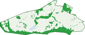
Green: 10 m cells where trees dominate, satellite 2021. Blue: water. The line is the suburb boundary.
| Canopy share, 1 m canopy height map, 2020 | 12.5% |
|---|---|
| Surveyed canopy, Greater Sydney aerial survey, 2019 | 11.3% |
| Land with trees, 10 m satellite map, 2021 | 25.1% |
Demographics
Unemployment 3% · Labour-force participation 77.8%
Population by age in Spring Farm
| 0-4 | 1,275 |
|---|---|
| 5-14 | 1,579 |
| 15-19 | 472 |
| 20-24 | 540 |
| 25-34 | 2,273 |
| 35-44 | 1,687 |
| 45-54 | 907 |
| 55-64 | 593 |
| 65-74 | 394 |
| 75-84 | 121 |
| 85+ | 28 |
Dwelling types in Spring Farm
| House | 3,006 |
|---|---|
| Townhouse | 172 |
| Apartment | 22 |
| Other | 0 |
Households by weekly income in Spring Farm
| <$650 | 166 |
|---|---|
| $650-1,499 | 543 |
| $1,500-2,999 | 1,418 |
| $3,000+ | 958 |
Top ancestries in Spring Farm
| Australian | 3,923 |
|---|---|
| English | 3,273 |
| Other | 1,564 |
| Irish | 819 |
| Scottish | 723 |
| Italian | 535 |
Housing tenure in Spring Farm
| Owned | 340 |
|---|---|
| Mortgage | 1,989 |
| Rented | 831 |
| Other | 15 |
Cars per household in Spring Farm
| 0 | 34 |
|---|---|
| 1 | 795 |
| 2 | 1,713 |
| 3 | 457 |
| 4+ | 183 |
Commute to work in Spring Farm
| Car | 2,821 |
|---|---|
| Train | 33 |
| Bus | 11 |
| Tram/ferry | 3 |
| Walked | 29 |
| Bicycle | 3 |
| Home | 1,363 |
Top countries of birth in Spring Farm
| India | 190 |
|---|---|
| England | 189 |
| New Zealand | 125 |
| Philippines | 92 |
| Fiji | 81 |
| South Africa | 52 |
Languages used at home in Spring Farm
| Spanish | 144 |
|---|---|
| Hindi | 126 |
| Punjabi | 116 |
| Arabic | 90 |
| Italian | 57 |
| Urdu | 55 |
Birds & Wildlife Nearby
139,301 bird observations recorded near Spring Farm — most often seen:
- Silvereye (9,013)
- Superb Fairy-wren (6,580)
- Noisy Miner (6,505)
- Australian Raven (5,919)
- Red-browed Finch (5,797)
- Rainbow Lorikeet (5,766)
- Common Myna (5,486)
- Bell Miner (5,395)
- Magpie-lark (5,300)
- Australian Wood Duck (5,258)
- Sulphur-crested Cockatoo (5,106)
- Australian White Ibis (4,964)
- Dusky Moorhen (4,703)
Show all 30 birds recorded near Spring Farm
- Australian Magpie (4,663)
- Pacific Black Duck (4,626)
- Willie Wagtail (4,576)
- Australasian Purple Swamphen (4,539)
- Eurasian Coot (4,470)
- Eastern Rosella (4,254)
- Grey Butcherbird (4,155)
- Australasian Grebe (4,013)
- Crested Pigeon (3,665)
- Welcome Swallow (3,327)
- Red-rumped Parrot (3,253)
- Little Pied Cormorant (3,107)
- Eastern Yellow Robin (3,075)
- Galah (3,038)
- Masked Lapwing (2,971)
- Pied Currawong (2,909)
- Yellow-faced Honeyeater (2,868)
Sightings reported by observers, not a survey, so the counts show what people record rather than what lives here. Source: Atlas of Living Australia.
Nearby Suburbs
The closest suburbs to Spring Farm:
- Elderslie (1.5 km)
- Narellan Vale (2.3 km)
- Narellan (2.7 km)
- Mount Annan (2.9 km)
- Camden (3.2 km)
- Camden South (3.5 km)
- Camden Park (4 km)
- Smeaton Grange (4.4 km)
Embed this suburb
Add this free Spring Farm stat card to your own site — just copy the code:
Preview:
Cite this page
Quoting these figures? Copy the credit line:
Keep an eye on Spring Farm
One email when this data meaningfully changes — new census figures, prices, rankings. No spam, unsubscribe anytime.
Streets
- Abbott Street (64)
- Abel Road (14)
- Abidi Street (45)
- Ancona Avenue (53)
- Archer Road (68)
- Arden Way (6)
- Arena Street (69)
- Argent Street (17)
- Asil Close (7)
- Attwood Road (5)
- Austen Boulevard (79)
- Bandara Circuit (85)
- Barrow Road (11)
- Beckham Street (18)
- Belmont Avenue (97)
- Bilson Road (47)
- Blain Road (44)
- Bluebell Crescent (96)
- Brookner Road (20)
- Brushtail Street (9)
- Bunya Place (17)
- Burrell Road (54)
- Campine Street (9)
- Campion Way (35)
- Cams Way (4)
- Cape Street (12)
- Cassidy Street (19)
- Caswell Road (33)
- Cattarin Street (19)
- Cilento Street (20)
- Cobbs Avenue (11)
- Conran Way (10)
- Corbett Close (10)
- Corder Drive (39)
- Craig Lane (12)
- Cuthbert Street (11)
- Danvers Road (37)
- Delaware Street (42)
- Denton Road (19)
- Derbyshire Road (48)
- Dewpoint Drive (17)
- Dorset Street (19)
- Dutton Street (41)
- Easton Avenue (129)
- Epsom Street (17)
- Ettlesdale Road (24)
- Faber Street (8)
- Facey Lane (10)
- Faverolle Drive (20)
- Fleming Street (31)
- Floyd Street (101)
- Galah Way (18)
- Gallina Drive (18)
- Garner Road (34)
- Garner Street (33)
- Garton Road (41)
- Geddes Street (33)
- Gore Road (12)
- Greenberg Street (23)
- Greenhill Street (14)
- Hampshire Boulevard (129)
- Harland Road (48)
- Hinton Street (17)
- Holland Drive (37)
- Hoop Place (7)
- Hoxton Place (21)
- Humphrey Street (5)
- Hurst Street (24)
- Ingham Street (36)
- Jacobson Road (9)
- Java Street (4)
- Jennings Crescent (70)
- Jewell Way (6)
- Kale Road (42)
- Keenan Street (12)
- Kerr Road (12)
- Laguna Street (12)
- Landon Street (12)
- Langshan Street (23)
- Leggett Street (28)
- Lewis Street (9)
- Limestone Avenue (54)
- Lowan Street (15)
- Macarthur Road (61)
- Maize Avenue (22)
- Maltin Street (8)
- Maran Street (23)
- Marshall Avenue (41)
- Mcgovern Street (52)
- Mcgregor Way (19)
- Millman Road (44)
- Minorca Circuit (114)
- Montazah Street (22)
- Mooney Street (38)
- Mora Way (5)
- Moreton Bay Avenue (24)
- Musgrave Avenue (10)
- Newman Street (18)
- Nicholson Parade (90)
- Norfolk Boulevard (14)
- Norton Street (14)
- Oates Street (20)
- Oilseed Way (6)
- Orwell Place (14)
- Oswald Street (4)
- Owens Street (46)
- Parkinson Road (13)
- Partridge Street (31)
- Pascoe Street (34)
- Pekin Street (42)
- Pipping Way (15)
- Plumage Crescent (11)
- Plymouth Boulevard (42)
- Pollard Street (1)
- Redcap Street (38)
- Reynolds Street (57)
- Rich Way (10)
- Richardson Road (91)
- Rosecomb Road (37)
- Runyon Street (32)
- Sands Street (10)
- Sava Street (27)
- Silky Road (38)
- Snyder Street (16)
- Softwood Street (38)
- Spring Farm Drive (54)
- Springs Road (200)
- Starke Street (21)
- Steele Avenue (8)
- Stern Road (4)
- Sultan Avenue (10)
- Summers Street (26)
- Synder Street (14)
- Tanner Close (8)
- Tegel Street (15)
- Thiele Street (23)
- Tolle Way (5)
- Tupman Street (42)
- Vine Lane (2)
- Wagner Road (52)
- Walnut Way (16)
- Waterglass Street (62)
- Wattle Street (20)
- Wicker Street (19)