Earlwood NSW 2206
8,338 addresses · 158 streets
Barton Electorate › Canterbury-Bankstown LGA › Earlwood · 10 km from Sydney
📦 Thinking of moving here? Read the Earlwood moving guide

Living Here
An established, leafy suburb in Sydney's inner south-west, Earlwood is family-oriented with a settled profile. Households average 2.8 people and the median age is 44. Median household income is $2,164 a week, with rent around $570.
Earlwood is a suburb of New South Wales, home to about 18,053 people, with a median age of 44. The typical household earns around $2,164 a week, with median rent near $570 a week. Most homes are houses. About 78% of households own their home and 21% rent. Most workers work from home. Common community backgrounds include Greek, Australian, English. On the ABS socio-economic scale it sits in decile 9 of 10 nationally — a relatively advantaged area.
Over time — Census 2001 → 2021
Dashed line: district figures for the Kingsgrove (North) - Earlwood statistical area (SA2), the smallest area the ABS published before 2011. Solid line: Earlwood itself.
Getting Around & Local Services
19 doctors & medical clinics
3 carpenters
Getting around. Train station: Bardwell Park, 800 m south · Metro station: Canterbury, 1.5 km north-west · Light rail stop: Dulwich Hill, 2 km north-east · Bus interchange: UTS Shuttle Bus, 7 km east · Airport: Sydney (Kingsford Smith) Airport, 5.6 km south-east.
Socio-economic Standing
Deciles from 1 (lowest) to 10 (highest), against all Australian suburbs. The overall figure weighs advantage and disadvantage together; economic resources counts income and housing, and education & jobs counts qualifications and occupation. They often differ. Source: ABS SEIFA 2021.
Tree cover
🌳 Tree canopy: 17% share of land under canopy · satellite map, 2020
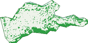
Green: 10 m cells where trees dominate, satellite 2021. Blue: water. The line is the suburb boundary.
| Canopy share, 1 m canopy height map, 2020 | 17.0% |
|---|---|
| Surveyed canopy, Greater Sydney aerial survey, 2019 | 18.9% |
| Land with trees, 10 m satellite map, 2021 | 25.3% |
Demographics
Unemployment 4% · Labour-force participation 55.7%
Population by age in Earlwood
| 0-4 | 870 |
|---|---|
| 5-14 | 2,139 |
| 15-19 | 1,102 |
| 20-24 | 979 |
| 25-34 | 1,841 |
| 35-44 | 2,274 |
| 45-54 | 2,841 |
| 55-64 | 2,279 |
| 65-74 | 1,718 |
| 75-84 | 1,380 |
| 85+ | 629 |
Dwelling types in Earlwood
| House | 4,915 |
|---|---|
| Townhouse | 509 |
| Apartment | 703 |
| Other | 5 |
Households by weekly income in Earlwood
| <$650 | 842 |
|---|---|
| $650-1,499 | 1,250 |
| $1,500-2,999 | 1,618 |
| $3,000+ | 2,062 |
Top ancestries in Earlwood
| Greek | 4,029 |
|---|---|
| Other | 3,237 |
| Australian | 3,044 |
| English | 2,692 |
| Italian | 1,616 |
| Lebanese | 1,405 |
Housing tenure in Earlwood
| Owned | 2,724 |
|---|---|
| Mortgage | 1,991 |
| Rented | 1,264 |
| Other | 84 |
Cars per household in Earlwood
| 0 | 535 |
|---|---|
| 1 | 2,288 |
| 2 | 2,113 |
| 3 | 703 |
| 4+ | 430 |
Commute to work in Earlwood
| Car | 2,354 |
|---|---|
| Train | 128 |
| Bus | 54 |
| Tram/ferry | 3 |
| Walked | 89 |
| Bicycle | 28 |
| Home | 3,719 |
Top countries of birth in Earlwood
| Greece | 1,331 |
|---|---|
| China | 533 |
| Vietnam | 431 |
| Lebanon | 429 |
| Italy | 396 |
| England | 321 |
Languages used at home in Earlwood
| Greek | 3,272 |
|---|---|
| Arabic | 1,008 |
| Italian | 610 |
| Vietnamese | 573 |
| Portuguese | 533 |
| Mandarin | 482 |
Birds & Wildlife Nearby
202,320 bird observations recorded near Earlwood — most often seen:
- Rainbow Lorikeet (14,157)
- Australian White Ibis (13,373)
- Noisy Miner (10,912)
- Common Myna (10,868)
- Australian Magpie (9,050)
- Australian Raven (8,599)
- Pied Currawong (8,364)
- Rock Dove (8,225)
- Spotted Turtle-dove (8,200)
- Magpie-lark (7,880)
- Welcome Swallow (7,787)
- Red-whiskered Bulbul (7,232)
- Superb Fairy-wren (6,893)
Show all 30 birds recorded near Earlwood
- Willie Wagtail (6,527)
- Common Starling (6,228)
- Chestnut Teal (5,897)
- Silvereye (5,633)
- Red Wattlebird (5,564)
- White-faced Heron (5,337)
- New Holland Honeyeater (5,225)
- Dusky Moorhen (4,732)
- Sulphur-crested Cockatoo (4,524)
- Crested Pigeon (4,479)
- Grey Butcherbird (4,478)
- Little Black Cormorant (4,090)
- Pacific Black Duck (3,957)
- Red-browed Finch (3,744)
- Laughing Kookaburra (3,725)
- Silver Gull (3,334)
- Grey Teal (3,306)
Sightings reported by observers, not a survey, so the counts show what people record rather than what lives here. Source: Atlas of Living Australia.
Nearby Suburbs
The closest suburbs to Earlwood:
- Bardwell Park (1.1 km)
- Bardwell Valley (1.5 km)
- Canterbury (1.5 km)
- Turrella (1.7 km)
- Hurlstone Park (1.8 km)
- Clemton Park (2 km)
- Bexley North (2.2 km)
- Arncliffe (2.3 km)
Embed this suburb
Add this free Earlwood stat card to your own site — just copy the code:
Preview:
Cite this page
Quoting these figures? Copy the credit line:
Keep an eye on Earlwood
One email when this data meaningfully changes — new census figures, prices, rankings. No spam, unsubscribe anytime.
Streets
- Airedale Avenue (15)
- Angus Street (40)
- Ann Street (19)
- Arncliffe Road (28)
- Ashton Avenue (14)
- Attunga Avenue (16)
- Bamboo Avenue (15)
- Banks Road (86)
- Bankside Avenue (15)
- Bardwell Crescent (35)
- Baringa Road (42)
- Barnes Avenue (32)
- Bass Road (117)
- Bayview Avenue (218)
- Bedford Street (61)
- Bexley Road (140)
- Birrellea Avenue (31)
- Boomerang Avenue (28)
- Braeside Crescent (20)
- Bramston Avenue (35)
- Bray Avenue (27)
- Burlington Avenue (56)
- Calbina Road (19)
- Cameron Avenue (22)
- Carboona Avenue (16)
- Caroline Street (33)
- Charleston Avenue (20)
- Clarke Street (99)
- Clemton Avenue (27)
- Collingwood Avenue (53)
- Coney Road (25)
- David Street (24)
- Dawson Avenue (17)
- Dellwood Avenue (23)
- Doris Avenue (19)
- Douglas Street (12)
- Earlwood Avenue (93)
- Elsie Street (28)
- Eulabah Avenue (24)
- Fauna Street (9)
- Faye Avenue (7)
- Finlays Avenue (36)
- Fleet Avenue (34)
- Flers Avenue (68)
- Flinders Road (67)
- Forrest Avenue (61)
- Francis Street (53)
- Fricourt Avenue (81)
- Frost Street (26)
- Fuller Avenue (33)
- Glenview Avenue (34)
- Gornall Avenue (25)
- Graham Place (8)
- Gretchen Avenue (25)
- Grove Street (86)
- Gueudecourt Avenue (89)
- Hamel Crescent (36)
- Hamilton Avenue (74)
- Hansen Avenue (17)
- Hartill-law Avenue (10)
- Highcliff Road (63)
- Highland Crescent (50)
- Hocking Avenue (64)
- Homer Lane (35)
- Homer Street (1,468)
- Hood Avenue (28)
- Hughes Street (3)
- Ibex Street (11)
- Jackson Place (6)
- Johnston Street (24)
- Joy Avenue (28)
- Karool Avenue (14)
- Keith Street (39)
- Kitchener Avenue (71)
- Lanark Avenue (13)
- Lang Road (5)
- Larkhall Avenue (7)
- Laurina Avenue (13)
- Leonard Crescent (11)
- Leonora Street (38)
- Lewins Street (26)
- Louisa Street (6)
- Lovat Avenue (18)
- Macleay Place (17)
- Macquarie Road (64)
- Main Street (63)
- Malley Avenue (61)
- Manildra Street (35)
- Marana Road (59)
- March Place (7)
- Mcgrath Avenue (15)
- Minnamorra Avenue (68)
- Mooney Avenue (30)
- Morgan Street (38)
- Narani Crescent (62)
- Nelson Road (59)
- Nicoll Avenue (31)
- Northcote Street (31)
- Olwyn Place (7)
- Osroy Avenue (31)
- Paris Avenue (37)
- Parker Avenue (29)
- Pembrew Crescent (17)
- Pembroke Avenue (20)
- Permanent Avenue (145)
- Pine Avenue (17)
- Polygon Crescent (3)
- Pomroy Avenue (8)
- Potter Avenue (22)
- Prince Edward Avenue (117)
- Richard Avenue (57)
- Richmond Street (97)
- River Street (122)
- Riverview Road (276)
- Ronald Avenue (29)
- Ryrie Road (69)
- Scahill Street (1)
- Schofield Avenue (38)
- Shaw Avenue (41)
- Singleton Street (17)
- Spark Street (38)
- St Georges Parade (16)
- St James Avenue (8)
- Stone Street (95)
- Summit Street (11)
- Sunset Place (16)
- Sutton Avenue (9)
- Tempe Street (11)
- The Entrance (3)
- The Walk (2)
- Thompson Street (92)
- Trewilga Avenue (13)
- Twyford Avenue (15)
- Undercliffe Lane (14)
- Undercliffe Road (140)
- Unwin Street (23)
- Vera Avenue (15)
- Vera Lane (1)
- View Street (22)
- Vimy Street (13)
- Wanstead Avenue (26)
- Warburton Parade (33)
- Wardell Road (323)
- Waterside Crescent (53)
- Watkin Avenue (14)
- Wavell Parade (20)
- Waygrove Avenue (18)
- Wellington Road (30)
- Westfield Street (36)
- William Street (395)
- Willunga Avenue (24)
- Winston Avenue (23)
- Wolli Avenue (116)
- Woodlawn Avenue (39)
- Woods Parade (17)
- Woolcott Street (181)
- Wyatt Avenue (17)
- Younger Avenue (12)