Arncliffe NSW 2205
6,494 addresses · 86 streets
Barton Electorate › Bayside LGA › Arncliffe · 10 km from Sydney
📦 Thinking of moving here? Read the Arncliffe moving guide

Living Here
Arncliffe is a suburb of New South Wales, home to about 12,023 people, with a median age of 34. The typical household earns around $2,046 a week, with median rent near $500 a week. Most homes are apartments. About 57% of households own their home and 41% rent. Most workers work from home. Common community backgrounds include Australian, English, Lebanese. On the ABS socio-economic scale it sits in decile 8 of 10 nationally — a relatively advantaged area.
Over time — Census 2001 → 2021
Dashed line: district figures for the Arncliffe - Bardwell Valley statistical area (SA2), the smallest area the ABS published before 2011. Solid line: Arncliffe itself.
Getting Around & Local Services
1 beach
8 childcare & kindergartens
Getting around. Train station: Arncliffe, 250 m north-east · Metro station: Marrickville, 2.8 km north · Light rail stop: Dulwich Hill, 3.1 km north · Bus interchange: UTS Shuttle Bus, 5.1 km east · Airport: Sydney (Kingsford Smith) Airport, 3.5 km east.
Socio-economic Standing
Deciles from 1 (lowest) to 10 (highest), against all Australian suburbs. The overall figure weighs advantage and disadvantage together; economic resources counts income and housing, and education & jobs counts qualifications and occupation. They often differ. Source: ABS SEIFA 2021.
Tree cover
🌳 Tree canopy: 12.5% share of land under canopy · satellite map, 2020
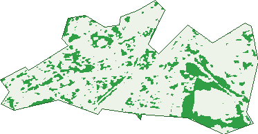
Green: 10 m cells where trees dominate, satellite 2021. Blue: water. The line is the suburb boundary.
| Canopy share, 1 m canopy height map, 2020 | 12.5% |
|---|---|
| Surveyed canopy, Greater Sydney aerial survey, 2019 | 14.1% |
| Land with trees, 10 m satellite map, 2021 | 18.4% |
Demographics
Unemployment 5.7% · Labour-force participation 57.4%
Population by age in Arncliffe
| 0-4 | 720 |
|---|---|
| 5-14 | 1,169 |
| 15-19 | 558 |
| 20-24 | 862 |
| 25-34 | 2,855 |
| 35-44 | 1,925 |
| 45-54 | 1,322 |
| 55-64 | 1,089 |
| 65-74 | 766 |
| 75-84 | 511 |
| 85+ | 246 |
Dwelling types in Arncliffe
| House | 1,626 |
|---|---|
| Townhouse | 436 |
| Apartment | 1,966 |
| Other | 20 |
Households by weekly income in Arncliffe
| <$650 | 521 |
|---|---|
| $650-1,499 | 848 |
| $1,500-2,999 | 1,394 |
| $3,000+ | 1,062 |
Top ancestries in Arncliffe
| Other | 2,986 |
|---|---|
| Australian | 1,597 |
| English | 1,535 |
| Lebanese | 1,493 |
| Chinese | 1,421 |
| Ancestry NS | 1,263 |
Housing tenure in Arncliffe
| Owned | 972 |
|---|---|
| Mortgage | 1,306 |
| Rented | 1,640 |
| Other | 84 |
Cars per household in Arncliffe
| 0 | 519 |
|---|---|
| 1 | 1,947 |
| 2 | 1,028 |
| 3 | 316 |
| 4+ | 179 |
Commute to work in Arncliffe
| Car | 1,929 |
|---|---|
| Train | 399 |
| Bus | 30 |
| Tram/ferry | 0 |
| Walked | 76 |
| Bicycle | 16 |
| Home | 2,013 |
Top countries of birth in Arncliffe
| China | 709 |
|---|---|
| Lebanon | 683 |
| North Macedonia | 349 |
| Philippines | 250 |
| Vietnam | 190 |
| New Zealand | 172 |
Languages used at home in Arncliffe
| Arabic | 1,750 |
|---|---|
| Mandarin | 761 |
| Macedonian | 517 |
| Spanish | 393 |
| Greek | 292 |
| Cantonese | 291 |
Birds & Wildlife Nearby
241,997 bird observations recorded near Arncliffe — most often seen:
- Australian White Ibis (15,575)
- Rainbow Lorikeet (14,991)
- Noisy Miner (12,452)
- Common Myna (11,720)
- Welcome Swallow (10,195)
- Australian Magpie (10,075)
- Magpie-lark (10,051)
- Pied Currawong (9,996)
- Australian Raven (9,909)
- Rock Dove (9,728)
- Spotted Turtle-dove (8,597)
- Willie Wagtail (8,407)
- Superb Fairy-wren (8,065)
Show all 30 birds recorded near Arncliffe
- Dusky Moorhen (7,855)
- Red-whiskered Bulbul (7,446)
- Chestnut Teal (7,091)
- Common Starling (7,065)
- Pacific Black Duck (6,983)
- Little Black Cormorant (6,700)
- New Holland Honeyeater (6,407)
- Red Wattlebird (6,138)
- White-faced Heron (6,131)
- Crested Pigeon (6,034)
- Silvereye (5,712)
- Silver Gull (5,267)
- Grey Butcherbird (5,210)
- Little Pied Cormorant (4,863)
- Laughing Kookaburra (4,549)
- Red-browed Finch (4,516)
- Sulphur-crested Cockatoo (4,269)
Sightings reported by observers, not a survey, so the counts show what people record rather than what lives here. Source: Atlas of Living Australia.
Nearby Suburbs
The closest suburbs to Arncliffe:
- Turrella (0.8 km)
- Banksia (1 km)
- Bardwell Valley (1.1 km)
- Wolli Creek (1.1 km)
- Rockdale (1.8 km)
- Bardwell Park (1.9 km)
- Kyeemagh (2 km)
- Earlwood (2.3 km)
Embed this suburb
Add this free Arncliffe stat card to your own site — just copy the code:
Preview:
Cite this page
Quoting these figures? Copy the credit line:
Keep an eye on Arncliffe
One email when this data meaningfully changes — new census figures, prices, rankings. No spam, unsubscribe anytime.
Streets
- Arncliffe Street (27)
- Athelstane Avenue (29)
- Atkinson Lane (4)
- Atkinson Street (48)
- Avenal Street (7)
- Barden Street (47)
- Bayview Street (58)
- Bellevue Court (10)
- Bellevue Lane (1)
- Bellevue Street (57)
- Belmore Street (119)
- Bidjigal Road (426)
- Bonar Street (341)
- Booth Street (27)
- Brennans Road (23)
- Broe Avenue (27)
- Burrows Street (18)
- Carlton Street (30)
- Charles Street (22)
- Denison Street (39)
- Done Street (40)
- Dowling Street (32)
- Duff Street (25)
- Duncan Street (98)
- Earle Street (7)
- Eden Street (230)
- Esdaile Place (7)
- Eve Street (18)
- Fairview Street (85)
- Farrar Street (12)
- Firmstone Gardens (26)
- Firth Street (144)
- Flora Street (41)
- Forest Road (368)
- Fripp Street (7)
- Gipps Street (12)
- Gore Street (35)
- Hattersley Street (39)
- Hill Street (30)
- Hirst Street (189)
- Horsell Avenue (11)
- Kelsey Street (34)
- Kembla Street (25)
- Knight Street (110)
- Kyle Street (236)
- Marinea Street (42)
- Marsh Street (16)
- Martin Avenue (91)
- Mary Street (1)
- Mitchell Street (14)
- Mount Street (57)
- Nattai Place (2)
- Niblick Street (10)
- Park Street (31)
- Pitt-owen Avenue (32)
- Princes Highway (907)
- Queen Street (97)
- Realm Street (14)
- Roach Street (56)
- Segenhoe Lane (1)
- Segenhoe Street (53)
- Somerville Street (30)
- Spring Street (100)
- Stanley Street (69)
- Station Street (161)
- Stewart Street (11)
- Tantallon Avenue (31)
- Tantallon Lane (2)
- Terry Lane (4)
- Terry Street (98)
- The Arcade (2)
- Towers Place (11)
- Towers Street (24)
- Union Street (18)
- Valda Avenue (28)
- View Street (55)
- Vincents Avenue (15)
- Walters Street (31)
- Waratah Street (33)
- Wardell Street (5)
- West Botany Street (162)
- Wickham Street (39)
- Wilsons Road (57)
- Withers Street (29)
- Wolli Creek Road (8)
- Wollongong Road (826)