Bardwell Valley NSW 2207
1,096 addresses · 31 streets
Barton Electorate › Bayside LGA › Bardwell Valley · 10 km from Sydney
📦 Thinking of moving here? Read the Bardwell Valley moving guide

Living Here
Bardwell Valley is a suburb of New South Wales, home to about 2,344 people, with a median age of 42. The typical household earns around $2,099 a week, with median rent near $550 a week. Most homes are houses. About 80% of households own their home and 18% rent. Most workers drive to work. Common community backgrounds include Australian, English, Lebanese. On the ABS socio-economic scale it sits in decile 9 of 10 nationally — a relatively advantaged area.
Over time — Census 2001 → 2021
Dashed line: district figures for the Arncliffe - Bardwell Valley statistical area (SA2), the smallest area the ABS published before 2011. Solid line: Bardwell Valley itself.
Getting Around & Local Services
88 schools
- Athelstane Public School
- Kingdom Culture Christian School
- Bardwell Park Infants School
- St Mary & St Mina's Coptic Orthodox College
- Our Lady of Lourdes Catholic Primary School
- Cairnsfoot Public School
- Bexley North Public School
- Bexley Primary School
- Arncliffe West Public School Preschool Centre
- Earlwood Public School
1 beach
2 playgrounds
Getting around. Train station: Bardwell Park, 950 m north-west · Metro station: Hurlstone Park, 2.9 km north · Light rail stop: Dulwich Hill, 3.1 km north · Bus interchange: UTS Shuttle Bus, 6.2 km east · Airport: Sydney (Kingsford Smith) Airport, 4.6 km east.
Socio-economic Standing
Deciles from 1 (lowest) to 10 (highest), against all Australian suburbs. The overall figure weighs advantage and disadvantage together; economic resources counts income and housing, and education & jobs counts qualifications and occupation. They often differ. Source: ABS SEIFA 2021.
Tree cover
🌳 Tree canopy: 15.3% share of land under canopy · satellite map, 2020
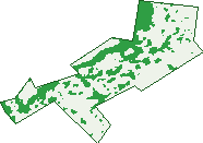
Green: 10 m cells where trees dominate, satellite 2021. Blue: water. The line is the suburb boundary.
| Canopy share, 1 m canopy height map, 2020 | 15.3% |
|---|---|
| Surveyed canopy, Greater Sydney aerial survey, 2019 | 20.4% |
| Land with trees, 10 m satellite map, 2021 | 24.4% |
Demographics
Unemployment 4.6% · Labour-force participation 54.2%
Population by age in Bardwell Valley
| 0-4 | 129 |
|---|---|
| 5-14 | 305 |
| 15-19 | 141 |
| 20-24 | 129 |
| 25-34 | 238 |
| 35-44 | 321 |
| 45-54 | 322 |
| 55-64 | 302 |
| 65-74 | 255 |
| 75-84 | 144 |
| 85+ | 52 |
Dwelling types in Bardwell Valley
| House | 520 |
|---|---|
| Townhouse | 214 |
| Apartment | 51 |
| Other | 0 |
Households by weekly income in Bardwell Valley
| <$650 | 126 |
|---|---|
| $650-1,499 | 149 |
| $1,500-2,999 | 222 |
| $3,000+ | 251 |
Top ancestries in Bardwell Valley
| Australian | 450 |
|---|---|
| English | 448 |
| Lebanese | 360 |
| Other | 347 |
| Greek | 227 |
| Chinese | 177 |
Housing tenure in Bardwell Valley
| Owned | 345 |
|---|---|
| Mortgage | 283 |
| Rented | 137 |
| Other | 16 |
Cars per household in Bardwell Valley
| 0 | 55 |
|---|---|
| 1 | 288 |
| 2 | 300 |
| 3 | 87 |
| 4+ | 46 |
Commute to work in Bardwell Valley
| Car | 375 |
|---|---|
| Train | 40 |
| Bus | 3 |
| Tram/ferry | 0 |
| Walked | 9 |
| Bicycle | 9 |
| Home | 366 |
Top countries of birth in Bardwell Valley
| Lebanon | 133 |
|---|---|
| China | 73 |
| North Macedonia | 63 |
| England | 54 |
| Greece | 51 |
| New Zealand | 44 |
Languages used at home in Bardwell Valley
| Arabic | 361 |
|---|---|
| Greek | 157 |
| Macedonian | 100 |
| Mandarin | 73 |
| Cantonese | 54 |
| Italian | 36 |
Birds & Wildlife Nearby
206,926 bird observations recorded near Bardwell Valley — most often seen:
- Rainbow Lorikeet (13,407)
- Australian White Ibis (13,349)
- Common Myna (10,918)
- Noisy Miner (10,424)
- Australian Raven (8,600)
- Australian Magpie (8,463)
- Magpie-lark (8,344)
- Rock Dove (8,246)
- Pied Currawong (8,157)
- Spotted Turtle-dove (8,107)
- Welcome Swallow (7,987)
- Red-whiskered Bulbul (7,261)
- Superb Fairy-wren (7,229)
Show all 30 birds recorded near Bardwell Valley
- Willie Wagtail (7,038)
- Common Starling (6,555)
- Chestnut Teal (6,323)
- New Holland Honeyeater (5,902)
- Red Wattlebird (5,511)
- Dusky Moorhen (5,507)
- Silvereye (5,502)
- White-faced Heron (5,249)
- Little Black Cormorant (4,793)
- Pacific Black Duck (4,694)
- Crested Pigeon (4,666)
- Red-browed Finch (4,447)
- Silver Gull (4,325)
- Grey Butcherbird (4,240)
- Sulphur-crested Cockatoo (4,230)
- Laughing Kookaburra (3,989)
- Grey Teal (3,463)
Sightings reported by observers, not a survey, so the counts show what people record rather than what lives here. Source: Atlas of Living Australia.
Nearby Suburbs
The closest suburbs to Bardwell Valley:
- Bardwell Park (0.8 km)
- Arncliffe (1.1 km)
- Turrella (1.1 km)
- Banksia (1.4 km)
- Earlwood (1.5 km)
- Bexley North (1.8 km)
- Rockdale (1.9 km)
- Bexley (2 km)
Embed this suburb
Add this free Bardwell Valley stat card to your own site — just copy the code:
Preview:
Cite this page
Quoting these figures? Copy the credit line:
Keep an eye on Bardwell Valley
One email when this data meaningfully changes — new census figures, prices, rankings. No spam, unsubscribe anytime.
Streets
- Alsace Avenue (10)
- Bardwell Road (24)
- Douglas Street (31)
- Dowling Street (58)
- Duff Street (2)
- East Street (35)
- Fairview Street (10)
- George Street (44)
- Gipps Street (52)
- Hamilton Street (33)
- Hannam Street (49)
- Hillcrest Avenue (26)
- Hirst Street (1)
- John Street (72)
- Lansdowne Street (28)
- Lapis Crescent (25)
- Lorraine Avenue (112)
- Mawson Street (37)
- Nayla Close (6)
- Orion Street (8)
- Parliament Terrace (4)
- Pile Street (9)
- Pindari Place (12)
- Sackville Street (84)
- Shepherd Parade (21)
- The Glen Road (146)
- Virginia Avenue (13)
- Wallendbeen Place (7)
- Wazir Street (67)
- Wentworth Street (22)
- Wilsons Road (48)