Welshpool WA 6106
2,478 addresses · 74 streets
Swan Electorate › Canning LGA › Welshpool · 9 km from Perth
📦 Thinking of moving here? Read the Welshpool moving guide

Living Here
Welshpool is a suburb of Western Australia, home to about 16 people, with a median age of 53. The typical household earns around $575 a week, with median rent near $265 a week. Most homes are houses. About 50% of households own their home and 0% rent. Most workers drive to work. Common community backgrounds include Filipino, Ancestry NS, English.
Over time — Census 2011 → 2021
Getting Around & Local Services
2 doctors & medical clinics
2 childcare & kindergartens
1 playground
1 bakery
2 butchers
4 beauty salons
Getting around. Train station: Oats Street, 2.4 km west · Metro station: Airport Central, 6.2 km north-east · Railway halt: Canning Junction, 4.4 km south-west · Bus interchange: Welshpool Bus Depot (Lost property Transperth), 700 m south-west · Airport: Perth Airport, 5.7 km north.
Tree cover
🌳 Tree canopy: 3% share of land under canopy · satellite map, 2020
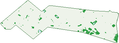
Green: 10 m cells where trees dominate, satellite 2021. Blue: water. The line is the suburb boundary.
| Canopy share, 1 m canopy height map, 2020 | 3.0% |
|---|---|
| Land with trees, 10 m satellite map, 2021 | 5.3% |
Demographics
Unemployment 12.5% · Labour-force participation 57.1%
Population by age in Welshpool
| 0-4 | 0 |
|---|---|
| 5-14 | 0 |
| 15-19 | 0 |
| 20-24 | 0 |
| 25-34 | 0 |
| 35-44 | 0 |
| 45-54 | 7 |
| 55-64 | 3 |
| 65-74 | 0 |
| 75-84 | 0 |
| 85+ | 0 |
Dwelling types in Welshpool
| House | 5 |
|---|---|
| Townhouse | 0 |
| Apartment | 0 |
| Other | 0 |
Top ancestries in Welshpool
| Filipino | 9 |
|---|---|
| Ancestry NS | 5 |
| English | 4 |
| Scottish | 4 |
| Australian | 0 |
| Aboriginal | 0 |
Housing tenure in Welshpool
| Owned | 0 |
|---|---|
| Mortgage | 3 |
| Rented | 0 |
| Other | 3 |
Cars per household in Welshpool
| 0 | 3 |
|---|---|
| 1 | 0 |
| 2 | 0 |
| 3 | 0 |
| 4+ | 0 |
Commute to work in Welshpool
| Car | 3 |
|---|---|
| Train | 0 |
| Bus | 0 |
| Tram/ferry | 0 |
| Walked | 0 |
| Bicycle | 0 |
| Home | 0 |
Top countries of birth in Welshpool
| Philippines | 9 |
|---|
Languages used at home in Welshpool
| Tagalog | 9 |
|---|
Birds & Wildlife Nearby
95,117 bird observations recorded near Welshpool — most often seen:
- Australian White Ibis (5,151)
- Pacific Black Duck (4,937)
- Laughing Turtle-dove (4,343)
- Southern Willie Wagtail (4,226)
- Eurasian Coot (4,180)
- Eastern Rainbow Lorikeet (3,971)
- South-western Singing Honeyeater (3,953)
- Dusky Moorhen (3,811)
- Western Brown Honeyeater (3,767)
- Western Australian Raven (3,759)
- Western Red Wattlebird (3,634)
- South-western Australian Magpie (3,460)
- Southern Magpie-lark (3,395)
Show all 30 birds recorded near Welshpool
- Eastern Asian Spotted Dove (3,143)
- Australian Wood Duck (3,079)
- Australasian Grebe (3,047)
- South-western New Holland Honeyeater (3,022)
- Western Galah (2,842)
- Twenty-eight Parrot (2,690)
- Grey Teal (2,591)
- Western Silvereye (2,531)
- Willie Wagtail (2,406)
- Australian Raven (2,371)
- Australian Shelduck (2,332)
- Western Striated Pardalote (2,246)
- Mainland Black-faced Cuckoo-shrike (2,204)
- Rainbow Lorikeet (2,072)
- Singing Honeyeater (2,009)
- Red Wattlebird (1,982)
- Western Welcome Swallow (1,963)
Sightings reported by observers, not a survey, so the counts show what people record rather than what lives here. Source: Atlas of Living Australia.
Nearby Suburbs
The closest suburbs to Welshpool:
- Queens Park (1.3 km)
- Kewdale (2 km)
- East Cannington (2.5 km)
- Carlisle (2.6 km)
- Cannington (2.7 km)
- St James (3 km)
- Cloverdale (3.3 km)
- Bentley (3.4 km)
Embed this suburb
Add this free Welshpool stat card to your own site — just copy the code:
Preview:
Cite this page
Quoting these figures? Copy the credit line:
Keep an eye on Welshpool
One email when this data meaningfully changes — new census figures, prices, rankings. No spam, unsubscribe anytime.
Streets
- Adams Drive (35)
- Adrian Street (50)
- Anvil Way (16)
- Atlas Court (19)
- Babel Road (8)
- Bank Street (28)
- Banksia Road (35)
- Beete Street (11)
- Bellows Street (13)
- Briggs Street (133)
- Carney Road (12)
- Casino Street (23)
- Colin Jamieson Drive (62)
- Collie Street (1)
- Dampier Road (22)
- Division Street (53)
- Dowd Street (117)
- Ellam Street (4)
- Embden Street (2)
- Ewing Street (48)
- Fargo Way (31)
- Felspar Street (44)
- Forge Street (20)
- Forward Street (25)
- Furnace Road (18)
- Glenferrie Road (1)
- Granite Place (10)
- Hantke Place (6)
- Harris Street (12)
- Hopetoun Place (17)
- John Street (33)
- Kalgan Road (6)
- Karratha Street (22)
- Kathleen Street (9)
- Kew Street (59)
- Kewdale Road (84)
- Kurnall Road (77)
- Mars Street (7)
- Mcdermott Street (6)
- Mcdowell Street (48)
- Mills Street (17)
- Moriarty Road (6)
- Murray Road N (14)
- Murray Road S (14)
- Orrong Road (41)
- Pilbara Street (66)
- Planet Street (38)
- Poole Street (56)
- President Street (127)
- Radium Street N (67)
- Railway Parade (22)
- Riversdale Road (9)
- Roy Street (7)
- Rutland Avenue (6)
- Sandra Place (9)
- Sheffield Road (65)
- Somersby Road (21)
- Star Street (103)
- Stott Road (10)
- Swansea Street E (2)
- Tate Street (2)
- Temperley Close (5)
- Tennant Street (34)
- Thorpe Close (5)
- Tilli Place (8)
- Tomah Road (8)
- Tomlinson Road (43)
- Treasure Road (86)
- Treasure Road N (80)
- Welshpool Road (271)
- Welshpool Road E (1)
- Western Lane (1)
- William Street (2)
- Zest Court (5)