Kewdale WA 6105
4,465 addresses · 125 streets
Swan Electorate › Belmont LGA › Kewdale · 7 km from Perth
📦 Thinking of moving here? Read the Kewdale moving guide

Living Here
Kewdale is a suburb of Western Australia, home to about 7,397 people, with a median age of 36. The typical household earns around $1,597 a week, with median rent near $350 a week. Most homes are houses. About 62% of households own their home and 37% rent. Most workers drive to work. Common community backgrounds include English, Australian, Chinese. On the ABS socio-economic scale it sits in decile 6 of 10 nationally — a mid-range area.
Over time — Census 2001 → 2021
Dashed line: district figures for the Rivervale - Kewdale - Cloverdale statistical area (SA2), the smallest area the ABS published before 2011. Solid line: Kewdale itself.
Getting Around & Local Services
3 pharmacies
1 medical clinic
2 dentists
2 physiotherapists
1 childcare centre
2 playgrounds
2 butchers
3 beauty salons
1 electrician
Getting around. Train station: Oats Street, 2.4 km south-west · Metro station: Airport Central, 5 km north-east · Railway halt: Canning Junction, 5.9 km south · Bus interchange: Welshpool Bus Depot (Lost property Transperth), 2.3 km south · Ferry wharf: Barrack Street Jetty, 7.4 km west · Airport: Perth Airport, 4.3 km north-east.
Socio-economic Standing
Deciles from 1 (lowest) to 10 (highest), against all Australian suburbs. The overall figure weighs advantage and disadvantage together; economic resources counts income and housing, and education & jobs counts qualifications and occupation. They often differ. Source: ABS SEIFA 2021.
Tree cover
🌳 Tree canopy: 3.6% share of land under canopy · satellite map, 2020
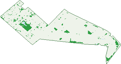
Green: 10 m cells where trees dominate, satellite 2021. Blue: water. The line is the suburb boundary.
| Canopy share, 1 m canopy height map, 2020 | 3.6% |
|---|---|
| Land with trees, 10 m satellite map, 2021 | 6.7% |
Demographics
Unemployment 5.1% · Labour-force participation 64%
Population by age in Kewdale
| 0-4 | 493 |
|---|---|
| 5-14 | 905 |
| 15-19 | 366 |
| 20-24 | 459 |
| 25-34 | 1,302 |
| 35-44 | 1,177 |
| 45-54 | 880 |
| 55-64 | 731 |
| 65-74 | 572 |
| 75-84 | 371 |
| 85+ | 142 |
Dwelling types in Kewdale
| House | 2,050 |
|---|---|
| Townhouse | 681 |
| Apartment | 127 |
| Other | 0 |
Households by weekly income in Kewdale
| <$650 | 464 |
|---|---|
| $650-1,499 | 771 |
| $1,500-2,999 | 921 |
| $3,000+ | 477 |
Top ancestries in Kewdale
| Other | 1,960 |
|---|---|
| English | 1,932 |
| Australian | 1,630 |
| Chinese | 626 |
| Irish | 503 |
| Scottish | 472 |
Housing tenure in Kewdale
| Owned | 842 |
|---|---|
| Mortgage | 903 |
| Rented | 1,052 |
| Other | 25 |
Cars per household in Kewdale
| 0 | 191 |
|---|---|
| 1 | 1,178 |
| 2 | 1,034 |
| 3 | 280 |
| 4+ | 139 |
Commute to work in Kewdale
| Car | 2,477 |
|---|---|
| Train | 40 |
| Bus | 211 |
| Tram/ferry | 0 |
| Walked | 48 |
| Bicycle | 20 |
| Home | 195 |
Top countries of birth in Kewdale
| England | 302 |
|---|---|
| India | 287 |
| New Zealand | 247 |
| China | 228 |
| Philippines | 209 |
| Pakistan | 193 |
Languages used at home in Kewdale
| Mandarin | 334 |
|---|---|
| Urdu | 234 |
| Arabic | 227 |
| Bengali | 204 |
| Italian | 119 |
| Cantonese | 112 |
Birds & Wildlife Nearby
101,232 bird observations recorded near Kewdale — most often seen:
- Australian White Ibis (5,733)
- Pacific Black Duck (5,611)
- Laughing Turtle-dove (4,737)
- Eurasian Coot (4,732)
- Southern Willie Wagtail (4,293)
- Dusky Moorhen (4,177)
- South-western Singing Honeyeater (4,039)
- Eastern Rainbow Lorikeet (3,851)
- Western Brown Honeyeater (3,690)
- Western Australian Raven (3,674)
- Western Red Wattlebird (3,466)
- Australian Wood Duck (3,464)
- Australasian Grebe (3,448)
Show all 30 birds recorded near Kewdale
- Southern Magpie-lark (3,403)
- South-western Australian Magpie (3,303)
- Eastern Asian Spotted Dove (3,203)
- Willie Wagtail (3,111)
- Australian Raven (2,922)
- South-western New Holland Honeyeater (2,857)
- Grey Teal (2,824)
- Singing Honeyeater (2,797)
- Rainbow Lorikeet (2,619)
- Western Galah (2,603)
- Red Wattlebird (2,585)
- Black Swan (2,529)
- Little Pied Cormorant (2,483)
- Twenty-eight Parrot (2,366)
- Australian Shelduck (2,339)
- Western Silvereye (2,227)
- Little Black Cormorant (2,146)
Sightings reported by observers, not a survey, so the counts show what people record rather than what lives here. Source: Atlas of Living Australia.
Nearby Suburbs
The closest suburbs to Kewdale:
- Cloverdale (1.6 km)
- Carlisle (1.8 km)
- Welshpool (2 km)
- Rivervale (2.7 km)
- Belmont (2.9 km)
- Lathlain (3 km)
- Queens Park (3.3 km)
- East Victoria Park (3.3 km)
Embed this suburb
Add this free Kewdale stat card to your own site — just copy the code:
Preview:
Cite this page
Quoting these figures? Copy the credit line:
Keep an eye on Kewdale
One email when this data meaningfully changes — new census figures, prices, rankings. No spam, unsubscribe anytime.
Streets
- Abernethy Road (71)
- Acton Avenue (231)
- Aitken Way (17)
- Armadale Road (112)
- Armitt Street (14)
- Arthur Street (34)
- Ashley Avenue (25)
- Baldwin Street (6)
- Ballantyne Road (25)
- Battaglia Place (6)
- Bell Street (2)
- Belmont Avenue (109)
- Blomfield Court (10)
- Boucher Street (11)
- Bradford Street (12)
- Briggs Street (56)
- Burchell Way (17)
- Casella Place (14)
- Cemy Place (56)
- Charlton Road (4)
- Chilver Street (5)
- Chisholm Crescent (69)
- Cohn Street (94)
- Compton Place (13)
- Coney Drive (6)
- Connaughton Street (23)
- Corser Street (18)
- Cottage Park Way (27)
- Daddow Road (3)
- Dixon Avenue (35)
- Downsborough Avenue (32)
- Draper Place (6)
- Durham Place (5)
- Elizabeth Street (14)
- Fenton Street (2)
- Ferguson Street (10)
- Fulham Street (223)
- Gabriel Place (3)
- Gabriel Street (11)
- Glassford Road (25)
- Green Street (14)
- Hampton Street (16)
- Harmony Way (25)
- Harrow Place (3)
- Harrow Street (31)
- Hazelhurst Street (14)
- Hedges Place (19)
- Henrietta Street (33)
- Hillcrest Road (40)
- Hodgson Way (11)
- Hotchkin Place (29)
- Jeffrey Street (37)
- Jenark Way (32)
- Kambalda Way (9)
- Keane Street (41)
- Kestal Place (26)
- Kew Street (105)
- Kewdale Road (77)
- Kingscote Street (7)
- Knutsford Avenue (260)
- Kooyong Road (61)
- Lance Place (11)
- Laurie Street (30)
- Leach Highway (19)
- Lemon Gum Court (11)
- Luscombe Street (29)
- Mackay Street (11)
- Maikai Place (26)
- Manor Place (10)
- Marchesi Street (11)
- Mcdermott Street (1)
- Mcdowell Street (2)
- Mcgill Street (29)
- Mercato Court (6)
- Mercury Street (69)
- Miles Road (19)
- Nance Street (19)
- Noble Street (11)
- Norlin Street (5)
- Oats Street (96)
- Orrong Place (19)
- Orrong Road (83)
- Osbourn Place (11)
- Paterson Road (28)
- Peace Loop (18)
- Peachey Avenue (52)
- Pegg Court (3)
- Penryn Court (5)
- Penryn Street (22)
- Perman Place (11)
- Picaro Place (9)
- President Street (94)
- Pritchard Street (13)
- Ray Road (33)
- Redgum Court (17)
- Reen Street (31)
- Reggio Road (11)
- Riebe Avenue (16)
- Rinsey Place (30)
- Rosina Street (8)
- Ross Street (39)
- Rowlands Street (64)
- Ruan Place (28)
- Scott Street (39)
- Shaw Place (9)
- Skinner Lane (8)
- St Kilda Road (145)
- Stockdale Road (48)
- Surrey Road (160)
- Sydenham Street (86)
- Terminal Road (6)
- Thompson Place (18)
- Tipping Road (10)
- Towers Street (2)
- Urquhart Place (23)
- Valentine Street (16)
- Villa Mews (20)
- Wharton Road (10)
- Wheatley Place (9)
- Wheatley Street (26)
- Wicca Street (95)
- Willow Tree Drive (35)
- Winton Street (2)
- Wright Street (247)
- Yomba Street (45)