Perth Airport WA 6105
591 addresses · 52 streets
Swan Electorate › Belmont LGA › Perth Airport · 10 km from Perth
📦 Thinking of moving here? Read the Perth Airport moving guide

Living Here
Perth Airport is a suburb of Western Australia, home to about 25 people, with a median age of 37. Common community backgrounds include Ancestry NS, Australian, Aboriginal. On the ABS socio-economic scale it sits in decile 9 of 10 nationally — a relatively advantaged area.
Over time — Census 2011 → 2021
Getting Around & Local Services
3 pharmacies
1 medical clinic
1 dentist
1 physiotherapist
1 optometrist
1 childcare centre
4 gyms & sports centres
1 dog park
2 butchers
2 hairdressers
3 mechanics
1 electrician
2 plumbers
Getting around. Train station: Airport Central, 850 m east · Metro station: Airport Central, 850 m east · Bus interchange: Long Term Parking B Bus Transfer, 1.8 km north-west · Airport: Perth Airport, 300 m west.
Socio-economic Standing
Deciles from 1 (lowest) to 10 (highest), against all Australian suburbs. The overall figure weighs advantage and disadvantage together; economic resources counts income and housing, and education & jobs counts qualifications and occupation. They often differ. Source: ABS SEIFA 2021.
Tree cover
🌳 Tree canopy: 7% share of land under canopy · satellite map, 2020
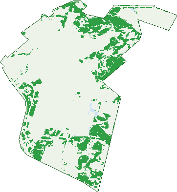
Green: 10 m cells where trees dominate, satellite 2021. Blue: water. The line is the suburb boundary.
| Canopy share, 1 m canopy height map, 2020 | 7.0% |
|---|---|
| Land with trees, 10 m satellite map, 2021 | 22.1% |
Demographics
Population by age in Perth Airport
| 0-4 | 0 |
|---|---|
| 5-14 | 0 |
| 15-19 | 0 |
| 20-24 | 0 |
| 25-34 | 7 |
| 35-44 | 10 |
| 45-54 | 0 |
| 55-64 | 0 |
| 65-74 | 0 |
| 75-84 | 0 |
| 85+ | 0 |
Top ancestries in Perth Airport
| Ancestry NS | 25 |
|---|---|
| Australian | 0 |
| Aboriginal | 0 |
| Chinese | 0 |
| Croatian | 0 |
| Dutch | 0 |
Top countries of birth in Perth Airport
| Vietnam | 5 |
|---|---|
| Iran | 4 |
| New Zealand | 4 |
Birds & Wildlife Nearby
69,481 bird observations recorded near Perth Airport — most often seen:
- Pacific Black Duck (4,119)
- Willie Wagtail (3,616)
- Australian White Ibis (3,329)
- Eurasian Coot (3,239)
- Australian Raven (3,221)
- Singing Honeyeater (2,908)
- Red Wattlebird (2,673)
- Rainbow Lorikeet (2,664)
- Grey Teal (2,520)
- Dusky Moorhen (2,518)
- Laughing Turtle-dove (2,473)
- Brown Honeyeater (2,471)
- Australian Wood Duck (2,468)
Show all 30 birds recorded near Perth Airport
- Australasian Grebe (2,449)
- Australasian Darter (2,385)
- Australasian Purple Swamphen (2,227)
- Magpie-lark (2,103)
- Australian Magpie (2,011)
- Little Pied Cormorant (2,000)
- South-western Australian Magpie (1,858)
- Spotted Turtle-dove (1,797)
- Galah (1,781)
- Little Black Cormorant (1,760)
- White-faced Heron (1,661)
- Australian Pelican (1,623)
- Australian Ringneck (1,597)
- Welcome Swallow (1,585)
- Little Corella (1,516)
- Silvereye (1,457)
- New Holland Honeyeater (1,452)
Sightings reported by observers, not a survey, so the counts show what people record rather than what lives here. Source: Atlas of Living Australia.
Nearby Suburbs
The closest suburbs to Perth Airport:
- Redcliffe (2 km)
- Cloverdale (2.9 km)
- Belmont (3.1 km)
- Ascot (3.5 km)
- High Wycombe (3.6 km)
- Ashfield (4 km)
- South Guildford (4.1 km)
- Kewdale (4.4 km)
Embed this suburb
Add this free Perth Airport stat card to your own site — just copy the code:
Preview:
Cite this page
Quoting these figures? Copy the credit line:
Keep an eye on Perth Airport
One email when this data meaningfully changes — new census figures, prices, rankings. No spam, unsubscribe anytime.
Streets
- Abbott Road (8)
- Abernethy Road (9)
- Adelaide Street (1)
- Affleck Road (17)
- Airport Drive (56)
- Anderson Place (11)
- Anson Road (1)
- Apac Way (3)
- Baker Road (1)
- Boud Avenue (5)
- Brearley Avenue (2)
- Brinsmead Road (1)
- Bungana Avenue (11)
- Central Avenue (1)
- Collopy Road (4)
- Colquhoun Road (4)
- Dawson Road (4)
- Duckworth Place (5)
- Dunreath Drive (7)
- Fauntleroy Avenue (10)
- Fawcett Crescent (12)
- Fricker Road (16)
- George Wiencke Drive (32)
- Grogan Road (11)
- High Street (127)
- Hitchcock Place (3)
- Horrie Miller Drive (40)
- Hudswell Road (2)
- Hugh Edwards Drive (36)
- Kalamunda Road (2)
- Kanowna Avenue E (1)
- Kingsford Smith Avenue (2)
- Lee Drive (2)
- Martin Road (6)
- Mccomb Road (1)
- Miller Road (18)
- Newburn Road (1)
- Newton Road (9)
- Paltridge Road (11)
- Redcliffe Road (3)
- Reid Road (11)
- Ross Drive (5)
- Searle Road (3)
- Snook Road (8)
- Sugarbird Lady Road (3)
- Talbot Road (1)
- Taplin Road (1)
- Tarlton Crescent (30)
- Ulm Place (7)
- Valentine Road (3)
- Whitham Road (18)
- Yagine Close (5)