Langford WA 6147
2,541 addresses · 78 streets
Burt Electorate › Gosnells LGA › Langford · 12 km from Perth
📦 Thinking of moving here? Read the Langford moving guide

Living Here
Langford is a suburb of Western Australia, home to about 5,505 people, with a median age of 36. The typical household earns around $1,318 a week, with median rent near $300 a week. Most homes are houses. About 65% of households own their home and 34% rent. Most workers drive to work. Common community backgrounds include English, Australian, Chinese. On the ABS socio-economic scale it sits in decile 2 of 10 nationally — a more disadvantaged area.
Over time — Census 2001 → 2021
Dashed line: district figures for the Beckenham - Kenwick - Langford statistical area (SA2), the smallest area the ABS published before 2011. Solid line: Langford itself.
Getting Around & Local Services
10 doctors & medical clinics
1 physiotherapist
2 dog parks
1 plumber
2 places to stay
Getting around. Train station: Thornlie, 1.3 km south-east · Railway halt: Canning Junction, 3 km north-west · Bus interchange: Transperth Beckenham Bus Depot, 2 km north · Airport: Jandakot Airport, 8.2 km south-west.
Socio-economic Standing
Deciles from 1 (lowest) to 10 (highest), against all Australian suburbs. The overall figure weighs advantage and disadvantage together; economic resources counts income and housing, and education & jobs counts qualifications and occupation. They often differ. Source: ABS SEIFA 2021.
Tree cover
🌳 Tree canopy: 11.5% share of land under canopy · satellite map, 2020
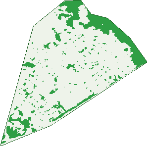
Green: 10 m cells where trees dominate, satellite 2021. Blue: water. The line is the suburb boundary.
| Canopy share, 1 m canopy height map, 2020 | 11.5% |
|---|---|
| Land with trees, 10 m satellite map, 2021 | 17.4% |
Demographics
Unemployment 8.2% · Labour-force participation 57.3%
Population by age in Langford
| 0-4 | 361 |
|---|---|
| 5-14 | 732 |
| 15-19 | 318 |
| 20-24 | 417 |
| 25-34 | 810 |
| 35-44 | 843 |
| 45-54 | 684 |
| 55-64 | 546 |
| 65-74 | 497 |
| 75-84 | 230 |
| 85+ | 58 |
Dwelling types in Langford
| House | 1,595 |
|---|---|
| Townhouse | 313 |
| Apartment | 3 |
| Other | 0 |
Households by weekly income in Langford
| <$650 | 359 |
|---|---|
| $650-1,499 | 649 |
| $1,500-2,999 | 576 |
| $3,000+ | 190 |
Top ancestries in Langford
| Other | 1,872 |
|---|---|
| English | 1,066 |
| Australian | 924 |
| Chinese | 812 |
| Ancestry NS | 427 |
| Indian | 276 |
Housing tenure in Langford
| Owned | 513 |
|---|---|
| Mortgage | 708 |
| Rented | 637 |
| Other | 20 |
Cars per household in Langford
| 0 | 114 |
|---|---|
| 1 | 734 |
| 2 | 618 |
| 3 | 266 |
| 4+ | 142 |
Commute to work in Langford
| Car | 1,685 |
|---|---|
| Train | 28 |
| Bus | 68 |
| Tram/ferry | 0 |
| Walked | 13 |
| Bicycle | 12 |
| Home | 88 |
Top countries of birth in Langford
| India | 290 |
|---|---|
| China | 244 |
| Malaysia | 243 |
| England | 179 |
| Indonesia | 172 |
| Philippines | 153 |
Languages used at home in Langford
| Mandarin | 393 |
|---|---|
| Cantonese | 201 |
| Indonesian | 189 |
| Bengali | 137 |
| Punjabi | 135 |
| Arabic | 123 |
Birds & Wildlife Nearby
108,883 bird observations recorded near Langford — most often seen:
- South-western Singing Honeyeater (5,425)
- Southern Willie Wagtail (5,412)
- Laughing Turtle-dove (5,281)
- Eastern Rainbow Lorikeet (5,263)
- Western Brown Honeyeater (5,202)
- Western Australian Raven (5,095)
- Western Red Wattlebird (5,046)
- Australian White Ibis (4,871)
- South-western Australian Magpie (4,778)
- Southern Magpie-lark (4,751)
- Eastern Asian Spotted Dove (4,439)
- Pacific Black Duck (4,432)
- South-western New Holland Honeyeater (4,377)
Show all 30 birds recorded near Langford
- Western Galah (4,196)
- Twenty-eight Parrot (4,031)
- Western Silvereye (3,505)
- Eurasian Coot (3,233)
- Mainland Black-faced Cuckoo-shrike (3,202)
- Western Striated Pardalote (3,066)
- Dusky Moorhen (3,029)
- Australian Wood Duck (2,575)
- Western Welcome Swallow (2,260)
- Inland Grey Butcherbird (2,137)
- Birds (2,129)
- Australasian Grebe (2,116)
- Grey Teal (1,878)
- Rock Dove (1,812)
- Australian Shelduck (1,797)
- Red-capped Parrot (1,776)
- Little Pied Cormorant (1,769)
Sightings reported by observers, not a survey, so the counts show what people record rather than what lives here. Source: Atlas of Living Australia.
Nearby Suburbs
The closest suburbs to Langford:
- Lynwood (1.1 km)
- Ferndale (1.9 km)
- Thornlie (2.5 km)
- Parkwood (2.7 km)
- Beckenham (2.8 km)
- Cannington (2.8 km)
- Kenwick (3.7 km)
- East Cannington (3.7 km)
Embed this suburb
Add this free Langford stat card to your own site — just copy the code:
Preview:
Cite this page
Quoting these figures? Copy the credit line:
Keep an eye on Langford
One email when this data meaningfully changes — new census figures, prices, rankings. No spam, unsubscribe anytime.
Streets
- Avocet Street (2)
- Baker Court (15)
- Barbados Link (15)
- Barnston Way (9)
- Boliver Place (7)
- Boxley Place (31)
- Brookman Avenue (85)
- Cameron Street (109)
- Capricorn Lane (4)
- Carroll Pass (6)
- Choseley Place (57)
- Clarice Court (11)
- Cortis Way (109)
- Cuba Lane (12)
- Cutten Place (31)
- Daly Circle (46)
- Downhill Way (31)
- Ellison Drive (28)
- Fellbridge Way (47)
- Finch Close (21)
- Foxwood Way (30)
- Gale Street (16)
- Gibson Street (33)
- Glasson Court (13)
- Goddard Way (40)
- Griffin Close (16)
- Hayden Way (73)
- Hester Street (26)
- Imber Turn (30)
- Ivers Court (12)
- Jamaica Crossing (29)
- Jenkins Lane (3)
- Jennings Court (10)
- Jewel Court (16)
- Knight Street (19)
- Langford Avenue (194)
- Latimer Way (37)
- Letsom Way (52)
- Lind Court (12)
- Marlee Court (21)
- Mcbain Court (21)
- Meyrick Way (73)
- Miami Link (6)
- Moncrieff Road (36)
- Montgomery Lane (9)
- Mudlark Close (16)
- Nicholson Road (51)
- Nightjar Lane (15)
- Norbury Way (76)
- Oak Tree Court (6)
- Osten Drive (50)
- Palin Court (13)
- Petry Street (4)
- Pigeon Court (10)
- Powis Court (17)
- Prendiville Way (42)
- Preston Road (5)
- Puncheon Street (18)
- Quail Place (25)
- Randall Way (27)
- Ranmere Way (50)
- Rapkin Street (7)
- Rhyl Place (19)
- Ruby Avenue (49)
- Simons Court (11)
- Simons Way (49)
- Southgate Road (77)
- Spencer Road (81)
- Towton Way (66)
- Turley Court (17)
- Turley Way (25)
- Upton Place (16)
- Valonia Road (11)
- View Avenue (50)
- Wagtail Bend (13)
- Ward Court (9)
- Wingrove Road (55)
- Woodmore Road (58)