Kenwick WA 6107
2,941 addresses · 106 streets
Burt Electorate › Gosnells LGA › Kenwick · 15 km from Perth
📦 Thinking of moving here? Read the Kenwick moving guide

Living Here
Kenwick is a suburb of Western Australia, home to about 5,684 people, with a median age of 35. The typical household earns around $1,433 a week, with median rent near $300 a week. Most homes are houses. About 70% of households own their home and 29% rent. Most workers drive to work. Common community backgrounds include English, Australian, Ancestry NS. On the ABS socio-economic scale it sits in decile 2 of 10 nationally — a more disadvantaged area.
Over time — Census 2001 → 2021
Dashed line: district figures for the Beckenham - Kenwick - Langford statistical area (SA2), the smallest area the ABS published before 2011. Solid line: Kenwick itself.
Getting Around & Local Services
4 doctors & medical clinics
2 physiotherapists
4 optometrists
12 hospitals
2 dog parks
3 bakeries
2 butchers
1 beauty salon
1 plumber
1 place to stay
Getting around. Train station: Kenwick, 950 m west · Railway halt: Canning Junction, 6.2 km west · Bus interchange: Transperth Beckenham Bus Depot, 3.3 km west · Airport: Perth Airport, 10.3 km north.
Socio-economic Standing
Deciles from 1 (lowest) to 10 (highest), against all Australian suburbs. The overall figure weighs advantage and disadvantage together; economic resources counts income and housing, and education & jobs counts qualifications and occupation. They often differ. Source: ABS SEIFA 2021.
Tree cover
🌳 Tree canopy: 8.8% share of land under canopy · satellite map, 2020
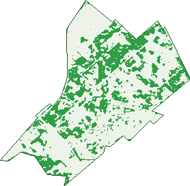
Green: 10 m cells where trees dominate, satellite 2021. Blue: water. The line is the suburb boundary.
| Canopy share, 1 m canopy height map, 2020 | 8.8% |
|---|---|
| Land with trees, 10 m satellite map, 2021 | 31.2% |
Demographics
Unemployment 7.8% · Labour-force participation 60.9%
Population by age in Kenwick
| 0-4 | 416 |
|---|---|
| 5-14 | 758 |
| 15-19 | 330 |
| 20-24 | 389 |
| 25-34 | 856 |
| 35-44 | 855 |
| 45-54 | 721 |
| 55-64 | 622 |
| 65-74 | 437 |
| 75-84 | 245 |
| 85+ | 52 |
Dwelling types in Kenwick
| House | 1,922 |
|---|---|
| Townhouse | 21 |
| Apartment | 6 |
| Other | 8 |
Households by weekly income in Kenwick
| <$650 | 308 |
|---|---|
| $650-1,499 | 638 |
| $1,500-2,999 | 592 |
| $3,000+ | 245 |
Top ancestries in Kenwick
| Other | 1,742 |
|---|---|
| English | 1,503 |
| Australian | 1,269 |
| Ancestry NS | 409 |
| Indian | 289 |
| Irish | 268 |
Housing tenure in Kenwick
| Owned | 478 |
|---|---|
| Mortgage | 868 |
| Rented | 552 |
| Other | 24 |
Cars per household in Kenwick
| 0 | 79 |
|---|---|
| 1 | 663 |
| 2 | 715 |
| 3 | 271 |
| 4+ | 191 |
Commute to work in Kenwick
| Car | 1,788 |
|---|---|
| Train | 83 |
| Bus | 24 |
| Tram/ferry | 0 |
| Walked | 34 |
| Bicycle | 10 |
| Home | 123 |
Top countries of birth in Kenwick
| India | 318 |
|---|---|
| Myanmar | 303 |
| England | 230 |
| Philippines | 210 |
| New Zealand | 144 |
| Indonesia | 96 |
Languages used at home in Kenwick
| Mandarin | 145 |
|---|---|
| Punjabi | 135 |
| Malayalam | 101 |
| Tagalog | 93 |
| Indonesian | 83 |
| Filipino | 76 |
Birds & Wildlife Nearby
62,400 bird observations recorded near Kenwick — most often seen:
- Western Brown Honeyeater (3,168)
- South-western Singing Honeyeater (3,081)
- Laughing Turtle-dove (2,988)
- Southern Willie Wagtail (2,932)
- Eastern Rainbow Lorikeet (2,864)
- Western Australian Raven (2,842)
- Australian White Ibis (2,808)
- Eastern Asian Spotted Dove (2,789)
- South-western Australian Magpie (2,774)
- Twenty-eight Parrot (2,696)
- Western Red Wattlebird (2,660)
- Western Galah (2,585)
- Southern Magpie-lark (2,566)
Show all 30 birds recorded near Kenwick
- South-western New Holland Honeyeater (2,464)
- Pacific Black Duck (2,160)
- Western Silvereye (2,073)
- Mainland Black-faced Cuckoo-shrike (2,070)
- Western Striated Pardalote (1,903)
- Inland Grey Butcherbird (1,614)
- Eurasian Coot (1,553)
- Red-capped Parrot (1,538)
- Forest Red-tailed Black-cockatoo (1,500)
- Dusky Moorhen (1,233)
- Grey Teal (1,207)
- Australian Wood Duck (1,205)
- Birds (1,144)
- Southern Rufous Whistler (1,070)
- Western Welcome Swallow (1,001)
- Rock Dove (960)
- Australian Shelduck (952)
Sightings reported by observers, not a survey, so the counts show what people record rather than what lives here. Source: Atlas of Living Australia.
Nearby Suburbs
The closest suburbs to Kenwick:
- Maddington (2.2 km)
- Beckenham (2.4 km)
- Thornlie (3.6 km)
- East Cannington (3.6 km)
- Langford (3.7 km)
- Orange Grove (3.7 km)
- Wattle Grove (3.9 km)
- Cannington (4.6 km)
Embed this suburb
Add this free Kenwick stat card to your own site — just copy the code:
Preview:
Cite this page
Quoting these figures? Copy the credit line:
Keep an eye on Kenwick
One email when this data meaningfully changes — new census figures, prices, rankings. No spam, unsubscribe anytime.
Streets
- Adana Elbow (50)
- Aladja Avenue (8)
- Albany Highway (191)
- Aldinga Street (26)
- Alton Street (19)
- Amarina Close (10)
- Austin Avenue (28)
- Avila Place (18)
- Bark Circle (25)
- Belaring Place (17)
- Bellata Place (8)
- Belmont Road (157)
- Bickley Road (79)
- Boab Cove (16)
- Bole Place (8)
- Boundary Road (7)
- Boydell Road (6)
- Brentwood Road (37)
- Bridal Crescent (58)
- Brill Street (5)
- Brixton Street (46)
- Brook Road (7)
- Burham Road (17)
- Calca Place (7)
- Carpenteria Crescent (28)
- Cayman Place (22)
- Chadwell Street (23)
- Chittick Cove (3)
- Coldwell Road (30)
- Cooper Avenue (5)
- Cranberry Way (14)
- Darel Close (6)
- Davison Street (2)
- Delbridge Drive (35)
- Dempsey Place (12)
- Denford Street (17)
- Dudley Road (28)
- Duketon Way (9)
- Edinbridge Road (26)
- Edward Street (15)
- Erith Street (9)
- Firetail Place (44)
- Foreman Street (1)
- Freight Road (11)
- Gaskin Road (58)
- Gayhurst Road (16)
- Gidgee Cove (15)
- Gilchrist Street (17)
- Gillen Street (10)
- Greygum Rise (19)
- Grimbsy Close (14)
- Grove Road (12)
- Hanson Street (7)
- Hinkler Street (24)
- Hythe Place (6)
- Intermodal Place (3)
- Jandoo Street (10)
- Kemi Close (19)
- Kenwick Link (1)
- Kenwick Road (197)
- Kidd Road (4)
- Lakewook Cove (32)
- Lalor Road (79)
- Liddelow Street (10)
- Linham Way (1)
- Logistics Boulevard (21)
- Maiyu Street (25)
- Manoora Place (14)
- Manup Court (8)
- Masters Street (26)
- Mccowan Street (16)
- Mcintyre Way (21)
- Mirrett Court (10)
- Moore Street (1)
- Myola Road (35)
- Namatjira Way (30)
- Needlewood Rise (20)
- Newman Place (6)
- Nyjong Street (4)
- Oakley Court (5)
- Oliphant Street (63)
- Osmond Street (35)
- Park Road (112)
- Phiel Court (17)
- Phoenix Drive (45)
- Pivac Court (14)
- Postling Street (49)
- Powderbark Bypass (28)
- Quondong Close (19)
- Rimmer Lane (9)
- Royal Street (61)
- Rupert Street (11)
- Shere Street (36)
- Short Street (30)
- Stafford Road (166)
- Staplehurst Street (8)
- Stretton Way (48)
- Summershill Gate (19)
- Telfer Place (13)
- Tindarra Close (7)
- Ulcombe Street (15)
- Vanilla Glade (12)
- Victoria Road (49)
- Vine Court (9)
- Wanaping Road (72)
- Weero Close (8)