Gosnells WA 6110
10,726 addresses · 301 streets
Burt Electorate › Gosnells LGA › Gosnells · 19 km from Perth
📦 Thinking of moving here? Read the Gosnells moving guide

Living Here
An affordable, established suburb in Perth's south-east, Gosnells is family-oriented and rail-connected. Households average 2.5 people and the median age is 38. Median household income is $1,254 a week, with rent around $290.
Gosnells is a suburb of Western Australia, home to about 21,149 people, with a median age of 38. The typical household earns around $1,254 a week, with median rent near $290 a week. Most homes are houses. About 65% of households own their home and 32% rent. Most workers drive to work. Common community backgrounds include English, Australian, Ancestry NS. On the ABS socio-economic scale it sits in decile 1 of 10 nationally — a more disadvantaged area.
Over time — Census 2001 → 2021
Dashed line: district figures for the Gosnells statistical area (SA2), the smallest area the ABS published before 2011. Solid line: Gosnells itself.
Getting Around & Local Services
1 beach
2 Catholic churches
2 physiotherapists
1 post office
1 playground
1 dog park
1 bakery
1 butcher
1 plumber
Getting around. Train station: Gosnells, 1.1 km north-east · Bus interchange: Transperth Swan Transit Depot, 2.6 km south-east · Airport: Jandakot Airport, 10.8 km west.
Socio-economic Standing
Deciles from 1 (lowest) to 10 (highest), against all Australian suburbs. The overall figure weighs advantage and disadvantage together; economic resources counts income and housing, and education & jobs counts qualifications and occupation. They often differ. Source: ABS SEIFA 2021.
Tree cover
🌳 Tree canopy: 11.5% share of land under canopy · satellite map, 2020
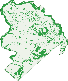
Green: 10 m cells where trees dominate, satellite 2021. Blue: water. The line is the suburb boundary.
| Canopy share, 1 m canopy height map, 2020 | 11.5% |
|---|---|
| Land with trees, 10 m satellite map, 2021 | 19.5% |
Demographics
Unemployment 8.9% · Labour-force participation 56%
Population by age in Gosnells
| 0-4 | 1,474 |
|---|---|
| 5-14 | 2,838 |
| 15-19 | 1,147 |
| 20-24 | 1,334 |
| 25-34 | 2,821 |
| 35-44 | 3,011 |
| 45-54 | 2,556 |
| 55-64 | 2,225 |
| 65-74 | 1,888 |
| 75-84 | 1,281 |
| 85+ | 584 |
Dwelling types in Gosnells
| House | 6,378 |
|---|---|
| Townhouse | 1,240 |
| Apartment | 239 |
| Other | 16 |
Households by weekly income in Gosnells
| <$650 | 1,740 |
|---|---|
| $650-1,499 | 2,513 |
| $1,500-2,999 | 2,277 |
| $3,000+ | 706 |
Top ancestries in Gosnells
| English | 7,330 |
|---|---|
| Australian | 5,862 |
| Other | 4,630 |
| Ancestry NS | 1,574 |
| Scottish | 1,395 |
| Irish | 1,351 |
Housing tenure in Gosnells
| Owned | 2,034 |
|---|---|
| Mortgage | 3,037 |
| Rented | 2,470 |
| Other | 209 |
Cars per household in Gosnells
| 0 | 601 |
|---|---|
| 1 | 3,110 |
| 2 | 2,620 |
| 3 | 913 |
| 4+ | 509 |
Commute to work in Gosnells
| Car | 6,364 |
|---|---|
| Train | 219 |
| Bus | 122 |
| Tram/ferry | 4 |
| Walked | 66 |
| Bicycle | 22 |
| Home | 305 |
Top countries of birth in Gosnells
| England | 1,356 |
|---|---|
| Philippines | 773 |
| New Zealand | 757 |
| India | 721 |
| Afghanistan | 469 |
| Myanmar | 367 |
Languages used at home in Gosnells
| Tagalog | 428 |
|---|---|
| Tamil | 317 |
| Punjabi | 290 |
| Mandarin | 270 |
| Urdu | 241 |
| Arabic | 236 |
Birds & Wildlife Nearby
22,820 bird observations recorded near Gosnells — most often seen:
- Forest Red-tailed Black-cockatoo (1,429)
- Twenty-eight Parrot (1,226)
- South-western Australian Magpie (1,196)
- Red-capped Parrot (1,002)
- New Holland Honeyeater (970)
- Laughing Turtle-dove (923)
- Western Australian Raven (890)
- Western Brown Honeyeater (890)
- Australian Raven (877)
- Galah (839)
- South-western New Holland Honeyeater (835)
- Western Galah (766)
- South-western Singing Honeyeater (756)
Show all 30 birds recorded near Gosnells
- Southern Magpie-lark (733)
- Western Red Wattlebird (718)
- Brown Honeyeater (677)
- Eastern Asian Spotted Dove (644)
- Western Striated Pardalote (622)
- Australian Ringneck (597)
- Silvereye (597)
- Western Silvereye (592)
- Pacific Black Duck (590)
- Willie Wagtail (586)
- Common Bronzewing (584)
- Splendid Fairy-wren (583)
- Southern Willie Wagtail (578)
- Mainland Black-faced Cuckoo-shrike (543)
- Australian Magpie (532)
- Eastern Rainbow Lorikeet (532)
- Red Wattlebird (513)
Sightings reported by observers, not a survey, so the counts show what people record rather than what lives here. Source: Atlas of Living Australia.
Nearby Suburbs
The closest suburbs to Gosnells:
- Huntingdale (2.5 km)
- Martin (2.6 km)
- Maddington (3.2 km)
- Camillo (4 km)
- Thornlie (4.1 km)
- Southern River (4.3 km)
- Champion Lakes (4.5 km)
- Kenwick (5 km)
Embed this suburb
Add this free Gosnells stat card to your own site — just copy the code:
Preview:
Cite this page
Quoting these figures? Copy the credit line:
Keep an eye on Gosnells
One email when this data meaningfully changes — new census figures, prices, rankings. No spam, unsubscribe anytime.
Streets
- Acott Road (25)
- Ailby Street (6)
- Albany Highway (619)
- Aldworth Crescent (24)
- Anaconda Drive (66)
- Ashburton Drive (84)
- Astinal Drive (58)
- Astley Street (296)
- Aston Way (19)
- Balgarup Drive (32)
- Bandy Place (5)
- Barcombe Way (28)
- Bardfield Way (10)
- Barming Street (20)
- Baron Way (41)
- Bayley Close (9)
- Bella Court (2)
- Belyea Street (27)
- Bert Street (186)
- Bexley Street (16)
- Bilby Place (18)
- Bilich Street (13)
- Birrel Place (19)
- Blackwood Street (2)
- Blanche Street (142)
- Blean Street (3)
- Brabham Street (37)
- Bray Street (22)
- Breeze Court (8)
- Brett Place (10)
- Brigham Court (13)
- Broadley Place (14)
- Brolga Place (7)
- Brome Street (6)
- Brook Place (4)
- Bryden Place (11)
- Burabur Street (16)
- Cane Court (10)
- Carey Place (14)
- Carmody Cove (8)
- Carnac Court (15)
- Carson Avenue (54)
- Carson Court (16)
- Casement Vista (1)
- Catlin Court (12)
- Chale Street (20)
- Chamberlain Street (136)
- Chandilla Street (27)
- Chapman Way (16)
- Charlesworth Street (16)
- Charnley Close (16)
- Chelsfield Street (35)
- Chenies Rest (15)
- Chilcott Gardens (7)
- Chilham Place (19)
- Clara Street (48)
- Cleve Way (9)
- Cliff Place (8)
- Cobb Place (10)
- Colleen Street (19)
- Colonial Place (11)
- Compton Road (14)
- Coolburra Court (16)
- Corbett Street (25)
- Corfield Street (271)
- Coulston Way (2)
- Crandon Street (184)
- Croft Street (32)
- Cue Court (6)
- Dandalup Road (9)
- Darkin Drive (24)
- Davies Court (8)
- Dawe Court (4)
- Degrey Close (3)
- Dene Court (12)
- Denison Court (5)
- Digby Street (98)
- Dillon Place (7)
- Dionne Place (22)
- Dorigo Place (18)
- Dorothy Street (210)
- Doubtful Chase (8)
- Dowitcher Loop (124)
- Drilby Way (4)
- Drysdale Street (4)
- Duleer Street (14)
- Durack Crescent (48)
- Dwyer Crescent (45)
- Ecton Street (26)
- Eileen Street (100)
- Elphick Street (8)
- Elsie Street (24)
- Emery Cove (4)
- Esther Place (14)
- Eudoria Street (200)
- Euro Close (12)
- Evelyn Street (184)
- Eynesford Street (70)
- Farnham Place (24)
- Federal Close (17)
- Fillmore Way (23)
- Fitzroy Court (13)
- Foreshore Place (7)
- Fortescue Bend (26)
- Frankland Court (20)
- Frederic Street (19)
- Fremantle Road (283)
- Garvey Place (18)
- Gascoyne Drive (25)
- George Street (48)
- Gerald Street (5)
- Gleed Court (13)
- Glennis Close (28)
- Goodall Street (44)
- Goudhurst Place (19)
- Greenhood Court (22)
- Greenough Way (49)
- Gwalia Place (7)
- Hadzy Court (7)
- Haine Street (6)
- Hamilton Court (50)
- Hann Court (15)
- Harold Street (44)
- Harry Street (85)
- Hartley Street (120)
- Harvey Close (8)
- Hemeleers Street (24)
- Hicks Street (243)
- Hillegine Court (51)
- Hillview Court (8)
- Holland Street (87)
- Homestead Road (165)
- Hood Place (10)
- Hosken Road (22)
- Hotham Way (8)
- Howells Place (13)
- Humphry Loop (35)
- Hutt Way (16)
- Ibis Court (6)
- Igran Crescent (5)
- Ilma Street (40)
- Irwin Close (14)
- Isdell Place (16)
- Ivanhoe Place (18)
- Jacana Place (21)
- James Street (90)
- Jarrah Grove (23)
- Jenal Close (10)
- Jenkinson Street (17)
- Jomar Court (8)
- Kalgan Pass (3)
- Keiley Green (14)
- Kellerman Way (56)
- Keston Place (20)
- Killarney Loop (24)
- Kindred Place (3)
- King Street (91)
- Kookaburra Way (13)
- Kyme Court (8)
- Lagrange Way (25)
- Lauterbach Drive (83)
- Lawrence Street (41)
- Lewin Court (21)
- Lissiman Street (47)
- Lockhart Place (15)
- Lorikeet Way (33)
- Lubberdina Court (13)
- Lutz Court (22)
- Lyals Way (8)
- Lydd Street (5)
- Lyminge Street (34)
- Lyne Street (7)
- Mackay Crescent (32)
- Magpie Place (18)
- Mala Lane (5)
- Manby Street (5)
- Manning Avenue (17)
- Mardo Lane (1)
- Margaret Street (17)
- Marquis Court (21)
- Matfield Way (32)
- May Street (121)
- Mayo Place (9)
- Meda Court (11)
- Meek Court (11)
- Meerup Lane (6)
- Michel Crescent (20)
- Mills Road W (16)
- Mimy Court (23)
- Minilya Court (6)
- Miranda Way (47)
- Moonstone Place (22)
- Moorland Loop (43)
- Morris Court (6)
- Morrow Lane (4)
- Mortlock Cove (8)
- Murchison Way (72)
- Muriel Street (45)
- Newbold Court (15)
- Newell Loop (27)
- Nicholas Street (45)
- Nicholli Court (9)
- Norman Street (31)
- Nullagine Way (19)
- Oakajee Court (13)
- Oakover Way (45)
- Omaha Court (14)
- Ord Pass (1)
- Orlestone Street (58)
- Orsett Way (18)
- Ospringe Street (54)
- Otley Place (7)
- Otterden Street (51)
- Owl Court (4)
- Pallinup Place (7)
- Papercap Street (8)
- Paringa Place (8)
- Parrot Court (8)
- Percy Street (38)
- Platte Court (9)
- Prescott Drive (42)
- Prince Regent Boulevard (25)
- Prince Street (60)
- Quarram Way (48)
- Queen Street (29)
- Rainbird Road (14)
- Rainbow Court (13)
- Rede Street (37)
- Redmond Road (41)
- Redtail Close (10)
- Reigate Street (28)
- Rex Street (28)
- Risby Street (59)
- River Bank Drive (38)
- Robina Road (24)
- Roderick Close (17)
- Rosekelly Road (33)
- Rosella Place (18)
- Rotary Avenue (14)
- Rowland Court (6)
- Rudall Close (12)
- Ryde Street (4)
- Sandridge Street (33)
- Sanford Street (1)
- Sarre Street (6)
- Sayer Crescent (24)
- Seaforth Avenue (76)
- Serpentine Meander (57)
- Settlers Way (9)
- Shannon Ramble (69)
- Shearwater Way (35)
- Sherlock Close (18)
- Shipton Street (3)
- Silda Place (10)
- Skinner Mews (6)
- Southern River Road (94)
- Spears Court (12)
- Stalker Road (153)
- Starick Way (25)
- Station Street (22)
- Stennett Street (56)
- Stephenson Road (15)
- Sturt Close (16)
- Swanley Street (29)
- Swingler Way (78)
- Tay Court (6)
- Teigh Street (14)
- Tenterden Way (22)
- Terence Street (165)
- Thomson Way (7)
- Thursley Way (4)
- Tone Court (7)
- Trayner Close (11)
- Trent Street (18)
- Valkyrie Place (8)
- Vasse Way (15)
- Vera Street (5)
- Verna Street (241)
- Vidich Street (4)
- Wade Street (20)
- Walker Place (15)
- Walpole Way (24)
- Walter Street (97)
- Wannoo Entrance (3)
- Warren Street (12)
- Watson Street (43)
- Wattle Way (1)
- Webb Street (23)
- Wedgewood Glade (13)
- Wexford Place (5)
- Wheatley Street (212)
- Wilkinson Street (47)
- Willet Lane (5)
- Wilsley Street (21)
- Wiluna Court (11)
- Windsor Drive (39)
- Wooramel Crescent (50)
- Wreford Court (53)
- Wyton Place (20)
- Yilgarn Way (8)