Carey Park WA 6230
3,103 addresses · 98 streets
Forrest Electorate › Bunbury LGA › Carey Park · 157 km from Perth
📦 Thinking of moving here? Read the Carey Park moving guide

Living Here
Carey Park is a suburb of Western Australia, home to about 5,155 people, with a median age of 40. The typical household earns around $1,018 a week, with median rent near $270 a week. Most homes are houses. About 52% of households own their home and 46% rent. Most workers drive to work. Common community backgrounds include English, Australian, Scottish. On the ABS socio-economic scale it sits in decile 1 of 10 nationally — a more disadvantaged area.
Over time — Census 2001 → 2021
Dashed line: district figures for the College Grove - Carey Park statistical area (SA2), the smallest area the ABS published before 2011. Solid line: Carey Park itself.
Getting Around & Local Services
1 Catholic church
3 doctors & medical clinics
2 childcare & kindergartens
3 post offices
9 service stations
2 golf clubs
2 butchers
2 hairdressers
1 beauty salon
1 carpenter
Getting around. Bus interchange: Bunbury Terminal, 1 km north-east · Airport: Bunbury Airport, 3.5 km south-east.
Socio-economic Standing
Deciles from 1 (lowest) to 10 (highest), against all Australian suburbs. The overall figure weighs advantage and disadvantage together; economic resources counts income and housing, and education & jobs counts qualifications and occupation. They often differ. Source: ABS SEIFA 2021.
Tree cover
🌳 Tree canopy: 9.7% share of land under canopy · satellite map, 2020
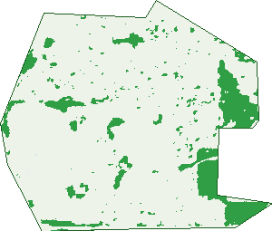
Green: 10 m cells where trees dominate, satellite 2021. Blue: water. The line is the suburb boundary.
| Canopy share, 1 m canopy height map, 2020 | 9.7% |
|---|---|
| Land with trees, 10 m satellite map, 2021 | 11.5% |
Demographics
Unemployment 7.4% · Labour-force participation 52.2%
Population by age in Carey Park
| 0-4 | 290 |
|---|---|
| 5-14 | 585 |
| 15-19 | 264 |
| 20-24 | 346 |
| 25-34 | 726 |
| 35-44 | 611 |
| 45-54 | 612 |
| 55-64 | 697 |
| 65-74 | 533 |
| 75-84 | 319 |
| 85+ | 176 |
Dwelling types in Carey Park
| House | 1,773 |
|---|---|
| Townhouse | 452 |
| Apartment | 0 |
| Other | 0 |
Households by weekly income in Carey Park
| <$650 | 622 |
|---|---|
| $650-1,499 | 772 |
| $1,500-2,999 | 523 |
| $3,000+ | 138 |
Top ancestries in Carey Park
| English | 2,243 |
|---|---|
| Australian | 1,924 |
| Scottish | 484 |
| Irish | 468 |
| Ancestry NS | 444 |
| Other | 314 |
Housing tenure in Carey Park
| Owned | 536 |
|---|---|
| Mortgage | 613 |
| Rented | 1,011 |
| Other | 31 |
Cars per household in Carey Park
| 0 | 224 |
|---|---|
| 1 | 992 |
| 2 | 695 |
| 3 | 204 |
| 4+ | 69 |
Commute to work in Carey Park
| Car | 1,598 |
|---|---|
| Train | 5 |
| Bus | 20 |
| Tram/ferry | 0 |
| Walked | 40 |
| Bicycle | 21 |
| Home | 41 |
Top countries of birth in Carey Park
| England | 229 |
|---|---|
| New Zealand | 144 |
| Philippines | 116 |
| Scotland | 26 |
| South Africa | 26 |
| India | 24 |
Languages used at home in Carey Park
| Tagalog | 49 |
|---|---|
| Mandarin | 37 |
| Filipino | 34 |
| Italian | 32 |
| Australian Indigenous | 20 |
| Urdu | 18 |
Birds & Wildlife Nearby
25,706 bird observations recorded near Carey Park — most often seen:
- Australian White Ibis (1,384)
- Little Pied Cormorant (1,182)
- Australian Raven (1,139)
- Willie Wagtail (1,122)
- Silver Gull (1,118)
- Pacific Black Duck (1,117)
- Red Wattlebird (1,044)
- Little Black Cormorant (1,014)
- Eurasian Coot (946)
- Australian Wood Duck (924)
- Black Swan (924)
- Laughing Turtle-dove (877)
- Common Bronzewing (865)
Show all 30 birds recorded near Carey Park
- Silvereye (854)
- Galah (849)
- Welcome Swallow (817)
- Great Egret (813)
- Australian Ringneck (749)
- New Holland Honeyeater (735)
- Australian Magpie (728)
- Dusky Moorhen (725)
- Australian Pelican (702)
- Brown Honeyeater (688)
- White-faced Heron (674)
- Australian Shelduck (662)
- Giinbaywarraymal (658)
- Rock Dove (624)
- Australasian Purple Swamphen (618)
- Southern Willie Wagtail (580)
- Little Corella (574)
Sightings reported by observers, not a survey, so the counts show what people record rather than what lives here. Source: Atlas of Living Australia.
Nearby Suburbs
The closest suburbs to Carey Park:
- South Bunbury (1.8 km)
- East Bunbury (1.9 km)
- Davenport (2.2 km)
- College Grove (2.6 km)
- Withers (2.6 km)
- Glen Iris (3.2 km)
- Bunbury (3.2 km)
- Usher (3.6 km)
Embed this suburb
Add this free Carey Park stat card to your own site — just copy the code:
Preview:
Cite this page
Quoting these figures? Copy the credit line:
Keep an eye on Carey Park
One email when this data meaningfully changes — new census figures, prices, rankings. No spam, unsubscribe anytime.
Streets
- Absolon Street (27)
- Armanta Drive (23)
- Ausden Street (17)
- Balgore Way (74)
- Bandak Road (22)
- Barr Road (29)
- Beagle Place (16)
- Belcher Street (13)
- Bergersen Court (4)
- Biesiot Street (31)
- Boyalla Street (31)
- Bramble Grove (10)
- Bright Street (58)
- Brittain Road (81)
- Bushell Street (25)
- Calgaret Street (12)
- Charterhouse Street (17)
- Ciara Street (4)
- Cingalese Close (16)
- Clarke Street E (90)
- Clyde Street (16)
- Corana Street (4)
- Dalhousie Street (14)
- Delaporte Way (25)
- Dillon Street (13)
- Dixon Street (29)
- Doolan Street (29)
- Downing Street (22)
- Dyinda Street (15)
- Ecclestone Street (83)
- Eedle Street (12)
- Eulalia Street (41)
- Flaherty Court (33)
- Flora Way (10)
- Forrest Avenue (117)
- Forrest Avenue E (24)
- Frankel Street (162)
- Galyung Road (17)
- Ganfield Street (65)
- Garda Way (1)
- Gerrard Place (11)
- Gibbs Street (87)
- Godwin Street (12)
- Gorman Loop (21)
- Gurinda Street (14)
- Gwinda Street (3)
- Hales Street (10)
- Hamersley Drive (30)
- Hands Avenue (49)
- Harland Street (21)
- Holtzman Place (20)
- Jindee Street (24)
- Jury Bend (36)
- Kimber Street (30)
- Kinkella Drive (15)
- Lawhill Entrance (11)
- Little Street (45)
- Locke Street (27)
- Lowe Street (69)
- Madras Street (4)
- Midas Street (5)
- Mili Court (7)
- Milligan Street (20)
- Minors Fairway (6)
- Mitchell Crescent (36)
- Mondak Place (25)
- Moolyeen Road (24)
- Mouarn Street (24)
- Nandup Street (14)
- Nielsen Grove (18)
- Nuytsia Avenue (74)
- Palmerston Street (8)
- Pierre Street (3)
- Plato Street (6)
- Queensbury Street (19)
- Raglan Street (24)
- Rodgers Place (9)
- Solglot Street (6)
- Steere Crescent (41)
- Stinton Street (28)
- Sweeny Street (36)
- Teeluk Road (17)
- Tipping Street (43)
- Twilight Terrace (37)
- Underwood Street (36)
- Walter Street (7)
- Waterwitch Street (25)
- Webber Street (37)
- Wilkes Street (28)
- Wilson Street (80)
- Windich Way (34)
- Winton Street (91)
- Wisbey Street (176)
- Woodrow Street (44)
- Woonnar Street (22)
- Xavier Street (62)
- Yorla Road (40)
- Young Close (20)