Bunbury WA 6230
4,081 addresses · 102 streets
Forrest Electorate › Bunbury LGA › Bunbury · 154 km from Perth
📦 Thinking of moving here? Read the Bunbury moving guide

Living Here
Bunbury is a suburb of Western Australia, home to about 3,948 people, with a median age of 49. The typical household earns around $1,614 a week, with median rent near $330 a week. Most homes are houses. About 59% of households own their home and 37% rent. Most workers drive to work. Common community backgrounds include English, Australian, Irish. On the ABS socio-economic scale it sits in decile 7 of 10 nationally — a mid-range area.
Over time — Census 2001 → 2021
Dashed line: district figures for the Bunbury statistical area (SA2), the smallest area the ABS published before 2011. Solid line: Bunbury itself.
Getting Around & Local Services
4 supermarkets
2 beaches
1 Catholic church
4 doctors & medical clinics
2 childcare & kindergartens
3 libraries
2 post offices
7 service stations
2 golf clubs
1 playground
1 butcher
3 hairdressers
3 beauty salons
1 carpenter
Getting around. Bus interchange: Bunbury Bus Stn, 300 m north · Airport: Bunbury Airport, 6.7 km south-east.
Socio-economic Standing
Deciles from 1 (lowest) to 10 (highest), against all Australian suburbs. The overall figure weighs advantage and disadvantage together; economic resources counts income and housing, and education & jobs counts qualifications and occupation. They often differ. Source: ABS SEIFA 2021.
Tree cover
🌳 Tree canopy: 6.1% share of land under canopy · satellite map, 2020
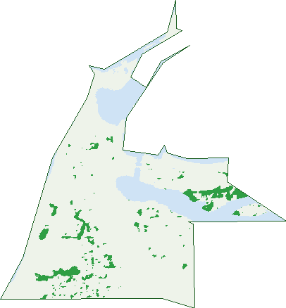
Green: 10 m cells where trees dominate, satellite 2021. Blue: water. The line is the suburb boundary.
| Canopy share, 1 m canopy height map, 2020 | 6.1% |
|---|---|
| Land with trees, 10 m satellite map, 2021 | 5.0% |
Demographics
Unemployment 4.3% · Labour-force participation 57.7%
Population by age in Bunbury
| 0-4 | 116 |
|---|---|
| 5-14 | 311 |
| 15-19 | 203 |
| 20-24 | 161 |
| 25-34 | 455 |
| 35-44 | 458 |
| 45-54 | 559 |
| 55-64 | 628 |
| 65-74 | 576 |
| 75-84 | 303 |
| 85+ | 179 |
Dwelling types in Bunbury
| House | 825 |
|---|---|
| Townhouse | 549 |
| Apartment | 268 |
| Other | 48 |
Households by weekly income in Bunbury
| <$650 | 274 |
|---|---|
| $650-1,499 | 468 |
| $1,500-2,999 | 475 |
| $3,000+ | 358 |
Top ancestries in Bunbury
| English | 1,759 |
|---|---|
| Australian | 1,178 |
| Irish | 492 |
| Scottish | 455 |
| Other | 331 |
| Ancestry NS | 312 |
Housing tenure in Bunbury
| Owned | 588 |
|---|---|
| Mortgage | 400 |
| Rented | 610 |
| Other | 65 |
Cars per household in Bunbury
| 0 | 101 |
|---|---|
| 1 | 745 |
| 2 | 615 |
| 3 | 153 |
| 4+ | 57 |
Commute to work in Bunbury
| Car | 1,357 |
|---|---|
| Train | 3 |
| Bus | 31 |
| Tram/ferry | 0 |
| Walked | 146 |
| Bicycle | 21 |
| Home | 122 |
Top countries of birth in Bunbury
| England | 308 |
|---|---|
| New Zealand | 104 |
| South Africa | 63 |
| Philippines | 44 |
| Scotland | 38 |
| India | 37 |
Languages used at home in Bunbury
| Italian | 30 |
|---|---|
| Mandarin | 24 |
| Tagalog | 19 |
| Afrikaans | 18 |
| Nepali | 18 |
| Spanish | 18 |
Birds & Wildlife Nearby
25,527 bird observations recorded near Bunbury — most often seen:
- Australian White Ibis (1,388)
- Little Pied Cormorant (1,234)
- Silver Gull (1,160)
- Pacific Black Duck (1,129)
- Willie Wagtail (1,125)
- Australian Raven (1,066)
- Little Black Cormorant (1,063)
- Red Wattlebird (995)
- Black Swan (949)
- Eurasian Coot (945)
- Australian Wood Duck (920)
- Laughing Turtle-dove (873)
- Great Egret (837)
Show all 30 birds recorded near Bunbury
- Common Bronzewing (821)
- Welcome Swallow (809)
- Silvereye (803)
- Galah (798)
- Australian Pelican (730)
- Dusky Moorhen (726)
- New Holland Honeyeater (711)
- White-faced Heron (691)
- Giinbaywarraymal (686)
- Australian Ringneck (677)
- Brown Honeyeater (663)
- Australian Shelduck (653)
- Australian Magpie (652)
- Rock Dove (637)
- Australasian Purple Swamphen (621)
- Southern Willie Wagtail (588)
- Australasian Darter (577)
Sightings reported by observers, not a survey, so the counts show what people record rather than what lives here. Source: Atlas of Living Australia.
Nearby Suburbs
The closest suburbs to Bunbury:
- East Bunbury (2.1 km)
- South Bunbury (2.3 km)
- Carey Park (3.2 km)
- Vittoria (3.4 km)
- Glen Iris (4.5 km)
- Withers (4.6 km)
- Davenport (5.1 km)
- Pelican Point (5.3 km)
Embed this suburb
Add this free Bunbury stat card to your own site — just copy the code:
Preview:
Cite this page
Quoting these figures? Copy the credit line:
Keep an eye on Bunbury
One email when this data meaningfully changes — new census figures, prices, rankings. No spam, unsubscribe anytime.
Streets
- Abrahamson Mews (5)
- Acacia Street (45)
- Albert Road (18)
- Armitage Street (15)
- Arthur Street (12)
- Avonbank Way (9)
- Banksia Street (22)
- Baudin Terrace (30)
- Beach Road (43)
- Bennett Way (19)
- Blair Street (115)
- Bonnefoi Boulevard (102)
- Bourke Street (27)
- Braund Street (33)
- Brend Tor Street (4)
- Brewery Lane (14)
- Brown Street (10)
- Carey Street (72)
- Carmody Place (3)
- Casuarina Drive (88)
- Charles Street (60)
- Clifton Street (86)
- Cobblestone Street (1)
- Cornwall Street (7)
- Cross Street (14)
- Ednie Street (16)
- Edward Street (23)
- Eliot Street (14)
- Forrest Avenue (1)
- Forster Street (26)
- Fraser Street (6)
- Garvey Place (14)
- George Street (32)
- Goldwyre Street (8)
- Greensell Street (78)
- Haig Crescent (35)
- Harrison Place (15)
- Haydock Street (15)
- Hayes Street (124)
- Henry Street (13)
- Holman Street (90)
- Irwin Street (4)
- Jarrah Street (20)
- Jetty Road (51)
- Karri Street (14)
- Koombana Drive (2)
- Lovegrove Avenue (14)
- Lumper Street (26)
- Lyons Cove (39)
- Macnish Close (10)
- Marabank Loop (28)
- Marlston Drive (74)
- Mervyn Street (3)
- Molloy Street (39)
- Money Street (21)
- Moore Street (86)
- Oakley Street (12)
- Ocean Drive (90)
- Ommanney Street (33)
- Palm Street (13)
- Park Street (13)
- Parkfield Street (42)
- Pickersgill Street (15)
- Picton Crescent (43)
- Prinsep Street (77)
- Ramsay Street (10)
- Reading Street (10)
- Roberts Crescent (10)
- Roman Road (22)
- Rose Street (32)
- Sampson Road (23)
- Samuel Wright Street (29)
- Scott Street (57)
- Sherry Street (23)
- Simpson Avenue (16)
- Sinclair Close (23)
- Spencer Street (154)
- Stanley Street (25)
- Stephen Street (89)
- Stirling Street (153)
- Stockley Road (61)
- Stone Street (9)
- Strickland Street (100)
- Stuart Street (39)
- Swansen Place (12)
- Symmons Street (48)
- Teede Street (9)
- The Strand (14)
- Thomas Street (50)
- Tuart Street (58)
- Turner Street (14)
- Upper Esplanade (135)
- Victoria Street (351)
- Wattle Street (76)
- Wellington Street (60)
- Wexford Lane (15)
- Whale View (37)
- William Street (48)
- Withers Crescent (9)
- Wittenoom Street (92)
- Wollaston Street (12)
- Zoe Street (23)