Bedfordale WA 6112
1,212 addresses · 73 streets
Canning Electorate › Armadale LGA › Bedfordale · 30 km from Perth
📦 Thinking of moving here? Read the Bedfordale moving guide

Living Here
Bedfordale is a suburb of Western Australia, home to about 3,038 people, with a median age of 42. The typical household earns around $2,722 a week, with median rent near $370 a week. Most homes are houses. About 96% of households own their home and 3% rent. Most workers drive to work. Common community backgrounds include English, Australian, Scottish. On the ABS socio-economic scale it sits in decile 9 of 10 nationally — a relatively advantaged area.
Over time — Census 2001 → 2021
Dashed line: district figures for the Mount Nasura - Mount Richon - Bedfordale statistical area (SA2), the smallest area the ABS published before 2011. Solid line: Bedfordale itself.
Getting Around & Local Services
1 park
2 Catholic churches
1 physiotherapist
2 optometrists
3 service stations
1 gym
1 golf club
1 hardware store
1 mechanic
1 place to stay
Getting around. Train station: Armadale, 4.3 km west · Bus interchange: Transperth Swan Transit Depot, 8.6 km north-west · Airport: Jandakot Airport, 18.5 km north-west.
Socio-economic Standing
Deciles from 1 (lowest) to 10 (highest), against all Australian suburbs. The overall figure weighs advantage and disadvantage together; economic resources counts income and housing, and education & jobs counts qualifications and occupation. They often differ. Source: ABS SEIFA 2021.
Tree cover
🌳 Tree canopy: 69.4% share of land under canopy · satellite map, 2020
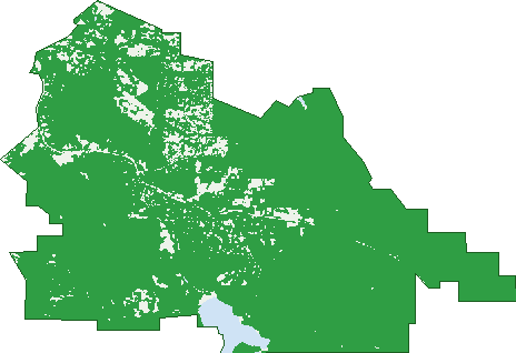
Green: 10 m cells where trees dominate, satellite 2021. Blue: water. The line is the suburb boundary.
| Canopy share, 1 m canopy height map, 2020 | 69.4% |
|---|---|
| Land with trees, 10 m satellite map, 2021 | 93.6% |
Demographics
Unemployment 3.1% · Labour-force participation 68.5%
Population by age in Bedfordale
| 0-4 | 135 |
|---|---|
| 5-14 | 442 |
| 15-19 | 242 |
| 20-24 | 185 |
| 25-34 | 222 |
| 35-44 | 383 |
| 45-54 | 536 |
| 55-64 | 459 |
| 65-74 | 272 |
| 75-84 | 144 |
| 85+ | 29 |
Dwelling types in Bedfordale
| House | 942 |
|---|---|
| Townhouse | 0 |
| Apartment | 4 |
| Other | 0 |
Households by weekly income in Bedfordale
| <$650 | 60 |
|---|---|
| $650-1,499 | 163 |
| $1,500-2,999 | 227 |
| $3,000+ | 387 |
Top ancestries in Bedfordale
| English | 1,586 |
|---|---|
| Australian | 1,047 |
| Scottish | 327 |
| Irish | 255 |
| Other | 251 |
| Dutch | 202 |
Housing tenure in Bedfordale
| Owned | 352 |
|---|---|
| Mortgage | 555 |
| Rented | 30 |
| Other | 9 |
Cars per household in Bedfordale
| 0 | 4 |
|---|---|
| 1 | 98 |
| 2 | 349 |
| 3 | 244 |
| 4+ | 242 |
Commute to work in Bedfordale
| Car | 1,154 |
|---|---|
| Train | 26 |
| Bus | 17 |
| Tram/ferry | 0 |
| Walked | 13 |
| Bicycle | 4 |
| Home | 157 |
Top countries of birth in Bedfordale
| England | 419 |
|---|---|
| New Zealand | 82 |
| South Africa | 68 |
| Netherlands | 31 |
| Scotland | 30 |
| Canada | 19 |
Languages used at home in Bedfordale
| Afrikaans | 32 |
|---|---|
| German | 19 |
| Italian | 14 |
| French | 9 |
| Cantonese | 7 |
| Mandarin | 7 |
Birds & Wildlife Nearby
16,380 bird observations recorded near Bedfordale — most often seen:
- Red-capped Parrot (810)
- New Holland Honeyeater (745)
- South-western Australian Magpie (722)
- Australian Raven (703)
- Red-tailed Black Cockatoo (692)
- Silvereye (661)
- Brown Honeyeater (654)
- Common Bronzewing (652)
- Australian Ringneck (648)
- Western Spinebill (644)
- Twenty-eight Parrot (618)
- Australian Magpie (581)
- Galah (575)
Show all 30 birds recorded near Bedfordale
- Splendid Fairy-wren (574)
- Grey Fantail (566)
- South-western Grey Fantail (543)
- Red Wattlebird (517)
- Western Gerygone (505)
- Western Thornbill (495)
- Gilbert's Honeyeater (458)
- Golden Whistler (456)
- Laughing Kookaburra (449)
- Weebill (410)
- Red-winged Fairy-wren (409)
- Scarlet Robin (406)
- Red-rumped Tit (404)
- South-western Spotted Scrubwren (390)
- Western Australian Raven (380)
- Pacific Black Duck (364)
- Western Wattlebird (349)
Sightings reported by observers, not a survey, so the counts show what people record rather than what lives here. Source: Atlas of Living Australia.
Nearby Suburbs
The closest suburbs to Bedfordale:
- Mount Richon (3.4 km)
- Mount Nasura (4.2 km)
- Wungong (4.7 km)
- Armadale (4.9 km)
- Brookdale (5.2 km)
- Roleystone (5.5 km)
- Kelmscott (6.1 km)
- Darling Downs (6.8 km)
Embed this suburb
Add this free Bedfordale stat card to your own site — just copy the code:
Preview:
Cite this page
Quoting these figures? Copy the credit line:
Keep an eye on Bedfordale
One email when this data meaningfully changes — new census figures, prices, rankings. No spam, unsubscribe anytime.
Streets
- Admiral Road (23)
- Admiral Road S (2)
- Albany Highway (100)
- Arania Place (13)
- Aulini Drive (21)
- Aviemore Drive (31)
- Benbecula Circle (21)
- Blake Street (4)
- Blissett Drive (30)
- Camfield Place (14)
- Canns Road (76)
- Carradine Road (44)
- Cartland Court (19)
- Chipper Close (10)
- Churchman Brook Road (16)
- Cross Road (20)
- Darling Range Drive (27)
- Devonleigh Street (4)
- Dmietrieff Road (13)
- Dowell Close (11)
- Dumas Drive (24)
- Dumas Road (23)
- Equestrian Avenue (10)
- Flello Rise (10)
- Frances Gregory Drive (22)
- Frogmore Close (6)
- Fyfield Way (12)
- Glencoe Place (12)
- Godwit Retreat (3)
- Grieve Way (30)
- Grono Road (13)
- Hitchens Grove (3)
- Howe Street (6)
- Keast Way (3)
- Kilfoyle Rise (12)
- Kimber Rise (7)
- Locke View (16)
- Meldrum Loop (42)
- Narbethong Road (13)
- Nelson Street (25)
- North Road (4)
- O'neill Place (6)
- Oban Loop (31)
- Observation Circle (43)
- Old Admiral Lane (6)
- Old Canns Lane (2)
- Otway Place (7)
- Paull View (9)
- Portree Street (8)
- Pridmore Place (7)
- Quorram Close (3)
- Red Cap Rise (2)
- Runnymede Way (4)
- Ryniker Road (10)
- Sewell Street (8)
- Skewes Way (13)
- Spinebill Close (1)
- Sprigg Road (4)
- Springfield Road (12)
- St Vincent Street (9)
- Stevens Road (13)
- Strapper Road (5)
- Trewarn Place (9)
- Triton Crescent (3)
- Vellender Road (13)
- Vincent Lookout (23)
- Wallangarra Drive (80)
- Waters Place (5)
- Waterwheel Road (31)
- Waterwheel Road N (35)
- Watling Place (6)
- Weelarra Heights (5)
- Wilcockson Close (4)