Armadale WA 6112
8,411 addresses · 255 streets
Burt Electorate › Armadale LGA › Armadale · 26 km from Perth
📦 Thinking of moving here? Read the Armadale moving guide

Living Here
A regional centre in Perth's outer south-east at the foot of the Darling Scarp, Armadale is affordable and growing. Households average 2.2 people and the median age is 39. Median household income is $1,020 a week, with rent around $270.
Armadale is a suburb of Western Australia, home to about 13,415 people, with a median age of 39. The typical household earns around $1,020 a week, with median rent near $270 a week. Most homes are houses. About 55% of households own their home and 41% rent. Most workers drive to work. Common community backgrounds include English, Australian, Ancestry NS. On the ABS socio-economic scale it sits in decile 1 of 10 nationally — a more disadvantaged area.
Over time — Census 2001 → 2021
Dashed line: district figures for the Armadale - Wungong - Brookdale statistical area (SA2), the smallest area the ABS published before 2011. Solid line: Armadale itself.
Getting Around & Local Services
2 Catholic churches
1 dentist
1 physiotherapist
2 optometrists
3 childcare & kindergartens
2 libraries
2 golf clubs
1 playground
2 butchers
4 hardware stores
3 beauty salons
1 place to stay
Getting around. Train station: Armadale, 700 m south-east · Bus interchange: Transperth Swan Transit Depot, 6 km north · Airport: Jandakot Airport, 13.6 km north-west.
Socio-economic Standing
Deciles from 1 (lowest) to 10 (highest), against all Australian suburbs. The overall figure weighs advantage and disadvantage together; economic resources counts income and housing, and education & jobs counts qualifications and occupation. They often differ. Source: ABS SEIFA 2021.
Tree cover
🌳 Tree canopy: 8.4% share of land under canopy · satellite map, 2020
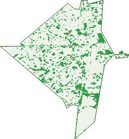
Green: 10 m cells where trees dominate, satellite 2021. Blue: water. The line is the suburb boundary.
| Canopy share, 1 m canopy height map, 2020 | 8.4% |
|---|---|
| Land with trees, 10 m satellite map, 2021 | 13.6% |
Demographics
Unemployment 12.7% · Labour-force participation 49.1%
Population by age in Armadale
| 0-4 | 920 |
|---|---|
| 5-14 | 1,544 |
| 15-19 | 731 |
| 20-24 | 911 |
| 25-34 | 1,874 |
| 35-44 | 1,611 |
| 45-54 | 1,570 |
| 55-64 | 1,588 |
| 65-74 | 1,440 |
| 75-84 | 874 |
| 85+ | 347 |
Dwelling types in Armadale
| House | 3,701 |
|---|---|
| Townhouse | 1,683 |
| Apartment | 89 |
| Other | 7 |
Households by weekly income in Armadale
| <$650 | 1,495 |
|---|---|
| $650-1,499 | 1,976 |
| $1,500-2,999 | 1,259 |
| $3,000+ | 264 |
Top ancestries in Armadale
| English | 5,557 |
|---|---|
| Australian | 4,295 |
| Other | 1,599 |
| Ancestry NS | 1,242 |
| Scottish | 1,142 |
| Irish | 949 |
Housing tenure in Armadale
| Owned | 1,300 |
|---|---|
| Mortgage | 1,677 |
| Rented | 2,222 |
| Other | 169 |
Cars per household in Armadale
| 0 | 611 |
|---|---|
| 1 | 2,473 |
| 2 | 1,562 |
| 3 | 480 |
| 4+ | 241 |
Commute to work in Armadale
| Car | 3,389 |
|---|---|
| Train | 142 |
| Bus | 51 |
| Tram/ferry | 0 |
| Walked | 83 |
| Bicycle | 13 |
| Home | 146 |
Top countries of birth in Armadale
| England | 1,182 |
|---|---|
| New Zealand | 446 |
| India | 230 |
| Philippines | 207 |
| Netherlands | 151 |
| Scotland | 119 |
Languages used at home in Armadale
| Malayalam | 91 |
|---|---|
| Tagalog | 89 |
| Mandarin | 77 |
| Filipino | 71 |
| Australian Indigenous | 51 |
| Punjabi | 51 |
Birds & Wildlife Nearby
36,519 bird observations recorded near Armadale — most often seen:
- South-western Australian Magpie (1,835)
- Twenty-eight Parrot (1,760)
- Western Brown Honeyeater (1,756)
- Western Australian Raven (1,740)
- Red-capped Parrot (1,736)
- South-western New Holland Honeyeater (1,697)
- Laughing Turtle-dove (1,677)
- Western Galah (1,674)
- Southern Magpie-lark (1,662)
- South-western Singing Honeyeater (1,646)
- Western Red Wattlebird (1,592)
- Mainland Black-faced Cuckoo-shrike (1,416)
- Birds (1,386)
Show all 30 birds recorded near Armadale
- Western Silvereye (1,384)
- Eastern Asian Spotted Dove (1,375)
- Southern Willie Wagtail (1,337)
- Eastern Rainbow Lorikeet (1,124)
- Western Striated Pardalote (1,085)
- White-faced Heron (916)
- Rock Dove (847)
- Pacific Black Duck (764)
- Collared Sparrowhawk (727)
- Mainland Tree Martin (727)
- Nankeen Kestrel (727)
- Australian Wood Duck (716)
- Southern Laughing Kookaburra (675)
- Western Wattlebird (661)
- Western White-cheeked Honeyeater (643)
- Straw-necked Ibis (621)
- Southern Australian Hobby (613)
Sightings reported by observers, not a survey, so the counts show what people record rather than what lives here. Source: Atlas of Living Australia.
Nearby Suburbs
The closest suburbs to Armadale:
- Mount Richon (1.8 km)
- Brookdale (2.1 km)
- Mount Nasura (2.1 km)
- Haynes (2.2 km)
- Seville Grove (2.3 km)
- Kelmscott (3.4 km)
- Hilbert (3.5 km)
- Wungong (3.6 km)
Embed this suburb
Add this free Armadale stat card to your own site — just copy the code:
Preview:
Cite this page
Quoting these figures? Copy the credit line:
Keep an eye on Armadale
One email when this data meaningfully changes — new census figures, prices, rankings. No spam, unsubscribe anytime.
Streets
- Abbey Road (46)
- Acacia Close (19)
- Agnew Place (4)
- Albany Highway (131)
- Allawah Court (11)
- Amaroo Court (30)
- Angelo Place (3)
- Angelo Street (59)
- Anham Street (7)
- Anton Street (27)
- Aragon Court (32)
- Armadale Road (32)
- Ash Court (18)
- Avard Place (22)
- Avonlee Road (24)
- Baccello Way (3)
- Badbury Road (30)
- Balanda Place (12)
- Ballina Way (19)
- Barellan Court (14)
- Barge Court (15)
- Baryna Street (19)
- Bavich Road (26)
- Bell Court (13)
- Benjamin Street (38)
- Bluegum Close (15)
- Blythe Place (9)
- Bonner Lane (27)
- Bowden Place (43)
- Brackley Road (41)
- Braemore Street (34)
- Brigalow Way (30)
- Briggs Place (12)
- Brixey Court (17)
- Brookdale Drive (25)
- Browning Road (13)
- Brumby Place (27)
- Burns Road (31)
- Burran Court (21)
- Burrowa Street (31)
- Byron Road (22)
- Cabarita Road (52)
- Cambell Road (29)
- Carringal Place (14)
- Castle Place (7)
- Challis Road (67)
- Chamberlain Way (27)
- Champion Drive (59)
- Cheritons Place (16)
- Church Avenue (103)
- Clarence Road (39)
- Claunelle Road (7)
- Clements Grove (9)
- Clybucca Place (10)
- Cobar Street (8)
- Cohuna Drive (36)
- Commerce Avenue (46)
- Coombe Avenue (12)
- Coonong Place (8)
- Coralie Court (66)
- Cordelia Road (46)
- Cornish Street (7)
- Cowan Street (52)
- Cowra Court (8)
- Crawley Road (22)
- Cronin Place (38)
- Cudal Place (17)
- Cull Court (8)
- Dale Road (150)
- Damerham Road (6)
- Damson Grove (15)
- Dawson Street (53)
- Deerness Way (39)
- Devereux Street (30)
- Devonshire Terrace (60)
- Dewar Street (14)
- Dickens Place (47)
- Donald Court (9)
- Doorigo Road (65)
- Dower Court (9)
- Dryandra Way (22)
- Dural Way (33)
- Duri Street (31)
- Edgeroi Way (29)
- Egan Street (5)
- Eighth Road (94)
- Elanora Road (30)
- Eliot Road (12)
- Eneabba Place (15)
- Exbury Road (27)
- Fifth Road (237)
- Forde Place (6)
- Forest Court (11)
- Forrest Road (141)
- Fountains Court (33)
- Fourth Road (70)
- Friar Road (88)
- Frys Lane (5)
- Galliers Avenue (43)
- Galong Place (17)
- Gaze Court (26)
- Gerald Street (4)
- Girraween Street (131)
- Gladstone Road (89)
- Glastonbury Road (27)
- Grealis Street (15)
- Green Avenue (18)
- Greengage Court (25)
- Gribble Avenue (91)
- Gymea Court (26)
- Hambledon Crescent (15)
- Harber Drive (18)
- Haynes Court (30)
- Herriard Road (8)
- Hickson Avenue (37)
- Hobbs Drive (32)
- Ikara Place (12)
- Ironcap Place (11)
- Ives Place (3)
- James Street (10)
- Janda Court (6)
- Jannali Way (44)
- John Street (89)
- Joyner Way (15)
- Jull Street (214)
- Junee Place (19)
- Karoonda Street (6)
- Keates Road (58)
- Kerun Court (15)
- Kiama Road (25)
- Kootingal Road (35)
- Kyabram Road (25)
- Kyogle Place (43)
- Lathwell Street (27)
- Law Crescent (30)
- Lensham Place (71)
- Leumeah Street (22)
- Lewis Court (11)
- Lilian Avenue (26)
- Lilika Street (33)
- Little John Road (113)
- Locksley Avenue (43)
- Lowanna Way (171)
- Mallee Place (8)
- Mardi Court (8)
- Marian Avenue (46)
- Masuli Way (27)
- May Close (11)
- Mccarthy Street (7)
- Mccormack Street (17)
- Mckeown Court (19)
- Mignon Court (16)
- Mill Place (5)
- Millman Way (2)
- Mogo Street (17)
- Mornington Street (28)
- Morrell Way (27)
- Murray Court (47)
- Namoi Place (14)
- Napean Place (7)
- Narooma Street (4)
- Nattai Court (14)
- Neilson Avenue (15)
- Nerang Court (11)
- Netley Place (23)
- Newton Court (13)
- Numulgi Street (36)
- Nyran Place (13)
- Offord Street (16)
- Olbah Place (5)
- Orchard Avenue (100)
- Oscar Street (7)
- Owtram Road (302)
- Pearson Street (8)
- Peel Court (15)
- Pelham Street (33)
- Phylma Street (16)
- Pigott Street (16)
- Pine Tree Close (47)
- Pollitt Close (14)
- Prospect Road (29)
- Prout Road (12)
- Quandong Place (10)
- Railway Avenue (116)
- Redross Court (22)
- Rice Place (8)
- Richard Place (11)
- Rigden Street (22)
- Ringwood Road (6)
- Robe Place (8)
- Robin Court (5)
- Robin Hood Avenue (59)
- Rogers Lane (4)
- Rupert Street (20)
- Schruth Street S (28)
- Scotia Place (17)
- Selby Street (7)
- Selkirk Road (15)
- Serls Street (97)
- Seventh Road (226)
- Sexty Street (33)
- Shanks Court (7)
- Sheoak Place (3)
- Sherbourne Way (24)
- Sheriff Place (7)
- Sherwood Court (14)
- Sinclair Street (17)
- Sixth Road (178)
- Smith Close (12)
- South Western Highway (41)
- Stepney Road (32)
- Stone Street (21)
- Stott Close (17)
- Streich Avenue (112)
- Tait Street (52)
- Tambulam Way (30)
- Tarrawan Road (34)
- Terrigal Way (34)
- The Grove (70)
- Third Avenue (1)
- Third Road (14)
- Thomas Street (21)
- Tijuana Road (41)
- Tillinga Street (2)
- Timbarra Street (19)
- Tomah Road (19)
- Tomlinson Place (23)
- Toongabbie Way (17)
- Toorak Road (29)
- Townley Street (68)
- Townsend Street (28)
- Treby Street (10)
- Tuck Street (34)
- Tudor Road (7)
- Umina Place (6)
- Urana Road (15)
- Verrill Way (16)
- Walcha Way (24)
- Waltham Court (4)
- Waltham Road (33)
- Wangoola Terrace (1)
- Warrina Place (20)
- Werndley Street (29)
- Westminster Court (16)
- Whiting Elbow (21)
- Wilcannia Way (63)
- William Street (70)
- Williams Road (30)
- Winchester Road (36)
- Windarra Way (31)
- Winnunga Place (15)
- Wungong Road (62)
- Wyee Place (9)
- Wyloo Place (9)
- Yarran Street (14)