Traralgon VIC 3844
16,297 addresses · 628 streets
Gippsland Electorate › Latrobe (Vic.) LGA › Traralgon · 144 km from Melbourne
📦 Thinking of moving here? Read the Traralgon moving guide

Living Here
The largest town in Victoria's Latrobe Valley, Traralgon is a regional service and energy centre. Households average 2.3 people and the median age is 39. Median household income is $1,484 a week, and at about $275 rent is very affordable.
Traralgon is a suburb of Victoria, home to about 26,907 people, with a median age of 39. The typical household earns around $1,484 a week, with median rent near $275 a week. Most homes are houses. About 72% of households own their home and 26% rent. Most workers drive to work. Common community backgrounds include English, Australian, Scottish. On the ABS socio-economic scale it sits in decile 3 of 10 nationally — a more disadvantaged area. The median house sells for about $507,000.
Over time — Census 2001 → 2021
Dashed line: district figures for the Traralgon statistical area (SA2), the smallest area the ABS published before 2011. Solid line: Traralgon itself.
Getting Around & Local Services
13 schools
- St Michael's Primary School
- Grey Street Primary School
- Stockdale Road Primary School
- Traralgon College Senior Campus
- Latrobe Special Development School
- Lavalla Catholic College St Paul's Campus
- Kosciuszko Street Primary School
- St Paul's Anglican Grammar School Traralgon Campus
- Lavalla Catholic College Kildare Campus
- St Gabriel's Primary School
5 supermarkets
1 Catholic church
3 pharmacies
5 doctors & medical clinics
1 physiotherapist
1 optometrist
2 hospitals
2 childcare & kindergartens
2 post offices
2 golf clubs
1 playground
1 dog park
1 butcher
3 hardware stores
2 hairdressers
Getting around. Train station: Traralgon, 750 m south-east · Airport: Latrobe Valley Airport, 5.8 km west.
Sport & Recreation
19 facilities recorded in Traralgon, the first 10 below.
- Agnes Brereton Park Netball
- Apex Park Australian Rules Football, Cricket
- Body and Soul Group Fitness Centre Fitness / Gymnasium Workouts
- Catterick Crescent Reserve Australian Rules Football, Cricket
- Curves Traralgon Fitness / Gymnasium Workouts
- Duncan Cameron Reserve Australian Rules Football, Cricket
- Harold Preston Reserve Athletics, Soccer
- Hubert Osborne Reserve Croquet
- Kevin Lythgo Park Baseball
- Traralgon BMX Track BMX
Socio-economic Standing
Deciles from 1 (lowest) to 10 (highest), against all Australian suburbs. The overall figure weighs advantage and disadvantage together; economic resources counts income and housing, and education & jobs counts qualifications and occupation. They often differ. Source: ABS SEIFA 2021.
Median Sale Prices
Median of recorded sales in the period, not a valuation. Source: Victorian Property Sales Report, Land Use Victoria.
Tree cover
🌳 Tree canopy: 6.5% share of land under canopy · satellite map, 2020
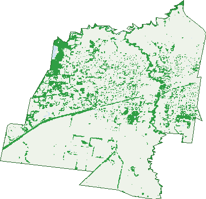
Green: 10 m cells where trees dominate, satellite 2021. Blue: water. The line is the suburb boundary.
| Canopy share, 1 m canopy height map, 2020 | 6.5% |
|---|---|
| Land with trees, 10 m satellite map, 2021 | 15.4% |
Demographics
Unemployment 5% · Labour-force participation 59.6%
Population by age in Traralgon
| 0-4 | 1,607 |
|---|---|
| 5-14 | 3,388 |
| 15-19 | 1,545 |
| 20-24 | 1,489 |
| 25-34 | 3,806 |
| 35-44 | 3,347 |
| 45-54 | 3,048 |
| 55-64 | 3,330 |
| 65-74 | 2,890 |
| 75-84 | 1,727 |
| 85+ | 726 |
Dwelling types in Traralgon
| House | 9,085 |
|---|---|
| Townhouse | 496 |
| Apartment | 975 |
| Other | 58 |
Households by weekly income in Traralgon
| <$650 | 2,000 |
|---|---|
| $650-1,499 | 2,999 |
| $1,500-2,999 | 3,133 |
| $3,000+ | 1,761 |
Top ancestries in Traralgon
| English | 10,820 |
|---|---|
| Australian | 10,481 |
| Scottish | 3,099 |
| Irish | 2,744 |
| Ancestry NS | 1,872 |
| Other | 1,711 |
Housing tenure in Traralgon
| Owned | 3,629 |
|---|---|
| Mortgage | 3,923 |
| Rented | 2,767 |
| Other | 149 |
Cars per household in Traralgon
| 0 | 631 |
|---|---|
| 1 | 3,927 |
| 2 | 4,056 |
| 3 | 1,237 |
| 4+ | 629 |
Commute to work in Traralgon
| Car | 8,886 |
|---|---|
| Train | 16 |
| Bus | 63 |
| Tram/ferry | 3 |
| Walked | 219 |
| Bicycle | 33 |
| Home | 1,411 |
Top countries of birth in Traralgon
| England | 666 |
|---|---|
| India | 326 |
| New Zealand | 282 |
| Philippines | 205 |
| Netherlands | 184 |
| Scotland | 174 |
Languages used at home in Traralgon
| Italian | 185 |
|---|---|
| Mandarin | 140 |
| Malayalam | 129 |
| Greek | 124 |
| Punjabi | 109 |
| Filipino | 85 |
Birds & Wildlife Nearby
15,335 bird observations recorded near Traralgon — most often seen:
- Australian Magpie (857)
- Pacific Black Duck (826)
- Australasian Purple Swamphen (762)
- Common Starling (711)
- Red Wattlebird (698)
- Eurasian Coot (693)
- Magpie-lark (681)
- Little Raven (675)
- Dusky Moorhen (648)
- Chestnut Teal (645)
- Rainbow Lorikeet (600)
- Eurasian Blackbird (594)
- Australian Wood Duck (564)
Show all 30 birds recorded near Traralgon
- Superb Fairy-wren (528)
- Common Myna (489)
- Pied Currawong (477)
- Spotted Turtle-dove (472)
- Grey Fantail (438)
- Sulphur-crested Cockatoo (387)
- Black Swan (382)
- Brown Thornbill (380)
- Welcome Swallow (369)
- Grey Teal (368)
- White-faced Heron (360)
- Little Pied Cormorant (334)
- Masked Lapwing (316)
- Laughing Kookaburra (290)
- Noisy Miner (275)
- Hardhead (260)
- Little Black Cormorant (256)
Sightings reported by observers, not a survey, so the counts show what people record rather than what lives here. Source: Atlas of Living Australia.
Nearby Suburbs
The closest suburbs to Traralgon:
- Traralgon East (3.6 km)
- Glengarry West (6.5 km)
- Tyers (7.1 km)
- Loy Yang (8.2 km)
- Glengarry (8.6 km)
- Hazelwood North (9.7 km)
- Maryvale (10 km)
- Morwell (11.1 km)
Embed this suburb
Add this free Traralgon stat card to your own site — just copy the code:
Preview:
Cite this page
Quoting these figures? Copy the credit line:
Keep an eye on Traralgon
One email when this data meaningfully changes — new census figures, prices, rankings. No spam, unsubscribe anytime.
Streets
- Jakobi Court (10)
- James Parade (30)
- Janette Street (19)
- Jarrah Court (15)
- Jaz Close (11)
- Jazmine Court (19)
- Jefferson Close (17)
- Jersey Street (18)
- Jim Court (8)
- John Street (22)
- Johnson Crescent (13)
- Jones Court (18)
- Josephine Court (9)
- Kaitlyn Court (15)
- Karri Court (16)
- Kasey Place (5)
- Kassandra Drive (38)
- Kavanagh Street (15)
- Kay Street (307)
- Keith Court (9)
- Kelleher Drive (20)
- Kelleher Street (17)
- Kenilworth Drive (42)
- Kennedy Close (9)
- Kestrel Close (12)
- Kevin Court (15)
- Keys Court (6)
- Kilkenny Close (27)
- Kimberley Drive (29)
- Kingsburgh Court (22)
- Kiwi Court (11)
- Kosciuszko Street (69)
- Lachlan Close (10)
- Lafayette Street (81)
- Lakeset Drive (10)
- Lakeview Lane (2)
- Lamprey Court (8)
- Lansdowne Road (37)
- Larnach Road (9)
- Latrobe Crescent (17)
- Laurence Grove (24)
- Lawn Avenue (19)
- Lawson Court (15)
- Le Grange (24)
- Leila Street (22)
- Leinster Avenue (19)
- Leon Terrace (4)
- Licola Court (6)
- Liddiard Road (223)
- Lighthorse Avenue (32)
- Limousin Way (8)
- Lindsay Court (11)
- Little Crescent (31)
- Livingstone Street (1)
- Lloyd Court (6)
- Loch Park Road (86)
- Lodge Drive (7)
- Lombard Street (27)
- Longford Court (8)
- Lorikeet Place (11)
- Louise Court (5)
- Lucas Street (1)
- Lyndon Crescent (21)
- Mabel Street (47)
- Macdougal Court (16)
- Mackay Street (7)
- Mackillop Court (16)
- Macquarie Place (7)
- Madsen Avenue (19)
- Mafeking Road (17)
- Maguire Court (4)
- Manley Circuit (13)
- Mapleson Drive (20)
- Margaret Street (13)
- Margies Place (5)
- Marie Street (33)
- Marion Court (3)
- Mark Drive (6)
- Marshalls Road (90)
- Mary Claire Street (23)
- Maryvale Court (6)
- Maskrey Street (29)
- Mason Street (13)
- Mates Street (5)
- Matthews Crescent (1)
- Mattingley Hill Road (2)
- Mayfair Court (18)
- Mayne Court (4)
- Mayo Close (17)
- Mccallum Court (8)
- Mcclure Court (15)
- Mcdonald Court (11)
- Mcentee Court (17)
- Mcmahon Street (61)
- Mcmillan Street (43)
- Mcnairn Road (42)
- Mcnulty Drive (67)
- Meadow Park Drive (28)
- Megan Place (9)
- Melanie Court (7)
- Melissa Court (7)
- Meredith Street (6)
- Meridian Drive (50)
- Merindah Court (12)
- Mermod Court (4)
- Mervyn Street (8)
- Michael Court (26)
- Michelle Court (12)
- Miles Street (12)
- Milligan Court (6)
- Milnes Road (2)
- Milton Court (7)
- Miranda Court (16)
- Mitchell Drive (22)
- Monaghan Close (17)
- Monash Street (14)
- Moonabeal Court (18)
- Moore Street (77)
- Morgan Drive (58)
- Morris Lane (5)
- Morrison Street (12)
- Mountbatten Court (13)
- Munro Street (48)
- Murphy Crescent (47)
- Murray Grey Avenue (14)
- Myrtle Crescent (18)
- Napier Place (10)
- Nefertiti Court (28)
- Negoura Court (5)
- Neville Street (19)
- Newman Crescent (79)
- Newry Drive (19)
- Nicholson Place (14)
- Nick Place (17)
- Nixon Court (14)
- Norah Street (9)
- Norman Street (14)
- Northern Avenue (16)
- Notting Hill (33)
- Nugong Place (24)
- Oak Avenue (31)
- Ohehir Court (8)
- Old Carrajung Road (7)
- Old Melbourne Road (30)
- Ormond Road (35)
- Orr Brien Crescent (12)
- Osborne Street (25)
- Oswald Street (2)
- Oxford Place (17)
- Oxley Court (11)
- Paige Avenue (39)
- Palmgate Terrace (23)
- Park Lane (308)
- Parkhaven Way (5)
- Parkwood Way (74)
- Parslow Court (21)
- Patricia Court (15)
- Patrobas Court (16)
- Paul Street (8)
- Pax Road (13)
- Paysley Road (13)
- Pedra Road (6)
- Penny Court (8)
- Pentland Court (4)
- Pepperdine Court (19)
- Peterkin Street (50)
- Pettit Street (23)
- Phelan Street (2)
- Phillip Street (75)
- Pioneers Court (9)
- Pollock Avenue (40)
- Poplar Avenue (35)
- Portabello Road (10)
- Post Office Place (36)
- Priestly Court (12)
- Princes Highway (128)
- Princes Street (138)
- Princeton Way (12)
- Purves Street (11)
- Quail Court (14)
- Queens Parade (68)
- Rainbird Court (16)
- Rangeview Drive (34)
- Raven Court (6)
- Ray Street (18)
- Regan Road (10)
- Regency Court (24)
- Regiment Lane (4)
- Retreat Road (19)
- Rialto Court (12)
- Riggall Road (16)
- Riley Street (28)
- Rimfire Court (5)
- Rise Boulevard (40)
- Riverslea Boulevard (138)
- Roberts Street (11)
- Rodeo Drive (36)
- Roebuck Bay (4)
- Rogers Court (12)
- Roosevelt Street (11)
- Roscommon Drive (27)
- Rose Avenue (28)
- Roseneath Street (33)
- Rostrevor Close (18)
- Rothbury Place (19)
- Row Street (17)
- Rural Drive (18)
- Rust View (21)
- Ryan Avenue (20)
- Rye Court (3)
- Salisbury Crescent (21)
- Sally Court (15)
- Sanctuary Lane (7)
- Sandalwood Court (14)
- Sara Court (7)
- Saunders Crescent (18)
- Saville Court (10)
- Scrubby Lane (25)
- Selma Court (7)
- Selwyn Place (10)
- Senade Court (10)
- Service Street (4)
- Seymour Street (118)
- Shakespeare Street (107)
- Sherwood Court (26)
- Short Street (11)
- Silk Road (11)
- Simmental Road (12)
- Simpson Court (9)
- Skipton Court (9)
- Sligo Court (18)
- Smith Street (14)
- Somers Place (6)
- Spearfelt Court (8)
- Springfield Court (12)
- St Georges Road (122)
- Stagg Street (12)
- Stanford Drive (11)
- Steele Court (9)
- Stirling Avenue (24)
- Stockdale Road (83)
- Stoddart Avenue (6)
- Stonehaven Road (22)
- Strathcole Drive (84)
- Strzelecki Court (6)
- Stuart Street (35)
- Summerhill Road (25)
- Sundale Road (52)
- Sunderland Circuit (39)
- Sunhill Rise (11)
- Sunset Place (11)
- Sussex Street (7)
- Swallow Grove (107)
- Swinburne Crescent (24)
- Tanjil Street (11)
- Tara Court (6)
- Tarago Court (11)
- Tasman Close (15)
- Tavel Close (7)
- Taylor Crescent (36)
- Taylors Road (8)
- Tennyson Street (31)
- The Avenue (59)
- Themi Place (6)
- Theotera Place (5)
- Thexton Street (22)
- Thomas Street (24)
- Thomson Rise (13)
- Tierney Court (11)
- Tintern Place (35)
- Tobruk Court (6)
- Toparoa Court (6)
- Toucan Court (6)
- Traralgon Creek Road (5)
- Traralgon West Road (11)
- Traralgon-maffra Road (20)
- Trent Court (18)
- Trivalve Court (8)
- Tucker Court (10)
- Tudor Court (7)
- Tulloch Way (52)
- Tyers Road (13)
- Tyrone Close (17)
- Tyson Place (2)
- Valley Drive (10)
- View Hill Drive (29)
- Village Avenue (52)
- Walhalla Court (6)
- Walhalla-tyers Road (2)
- Walker Crescent (20)
- Wall Street (7)
- Wallace Court (11)
- Walshs Road (6)
- Washington Street (79)
- Waterford Court (11)
- Waterrun Close (11)
- Waterside Drive (2)
- Watkins Court (7)
- Watson Court (7)
- Wattle Court (12)