Morwell VIC 3840
9,842 addresses · 348 streets
Gippsland Electorate › Latrobe (Vic.) LGA › Morwell · 135 km from Melbourne
📦 Thinking of moving here? Read the Morwell moving guide

Living Here
A Latrobe Valley town in Gippsland with a power-industry history, Morwell is among the most affordable places to rent in the state. Households average 2.2 people and the median age is 43. Median household income is $942 a week, with rent around $215.
Morwell is a suburb of Victoria, home to about 14,389 people, with a median age of 43. The typical household earns around $942 a week, with median rent near $215 a week. Most homes are houses. About 64% of households own their home and 35% rent. Most workers drive to work. Common community backgrounds include English, Australian, Ancestry NS. On the ABS socio-economic scale it sits in decile 1 of 10 nationally — a more disadvantaged area. The median house sells for about $335,000.
Over time — Census 2001 → 2021
Dashed line: district figures for the Morwell statistical area (SA2), the smallest area the ABS published before 2011. Solid line: Morwell itself.
Getting Around & Local Services
3 cafés & restaurants
3 supermarkets
1 Catholic church
2 pharmacies
1 medical clinic
1 physiotherapist
2 hospitals
1 vet
1 library
1 post office
6 service stations
2 gyms & sports centres
1 hardware store
1 hairdresser
1 mechanic
Getting around. Train station: Morwell, 1.6 km south-west · Bus interchange: Morwell Bus Interchange, 1.6 km south-west · Airport: Latrobe Valley Airport, 5.2 km north-east.
Sport & Recreation
15 facilities recorded in Morwell, the first 10 below.
- Crinigan Road South Reserve Cricket, Soccer
- Keegan St Reserve Australian Rules Football, Cricket, Lawn Bowls, Tennis (Outdoor)
- Latrobe City Sports & Entertainment Stadium Soccer
- Latrobe Leisure Morwell Basketball, Swimming
- Maryvale Oval Cricket
- Morwell BMX & Skate Park BMX, Skating
- Morwell GoKarts Motor Sports
- Morwell Golf Club Golf
- Morwell Park Netball Centre Netball
- Morwell Recreation Reserve Australian Rules Football, Cricket, Croquet, Netball
Socio-economic Standing
Deciles from 1 (lowest) to 10 (highest), against all Australian suburbs. The overall figure weighs advantage and disadvantage together; economic resources counts income and housing, and education & jobs counts qualifications and occupation. They often differ. Source: ABS SEIFA 2021.
Median Sale Prices
Median of recorded sales in the period, not a valuation. Source: Victorian Property Sales Report, Land Use Victoria.
Tree cover
🌳 Tree canopy: 10.9% share of land under canopy · satellite map, 2020
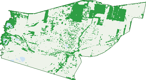
Green: 10 m cells where trees dominate, satellite 2021. Blue: water. The line is the suburb boundary.
| Canopy share, 1 m canopy height map, 2020 | 10.9% |
|---|---|
| Land with trees, 10 m satellite map, 2021 | 23.9% |
Demographics
Unemployment 11% · Labour-force participation 44.4%
Population by age in Morwell
| 0-4 | 821 |
|---|---|
| 5-14 | 1,678 |
| 15-19 | 764 |
| 20-24 | 870 |
| 25-34 | 1,772 |
| 35-44 | 1,503 |
| 45-54 | 1,761 |
| 55-64 | 1,960 |
| 65-74 | 1,746 |
| 75-84 | 1,050 |
| 85+ | 475 |
Dwelling types in Morwell
| House | 4,996 |
|---|---|
| Townhouse | 366 |
| Apartment | 425 |
| Other | 23 |
Households by weekly income in Morwell
| <$650 | 1,724 |
|---|---|
| $650-1,499 | 2,058 |
| $1,500-2,999 | 1,140 |
| $3,000+ | 416 |
Top ancestries in Morwell
| English | 5,217 |
|---|---|
| Australian | 4,939 |
| Ancestry NS | 1,730 |
| Scottish | 1,328 |
| Irish | 1,156 |
| Other | 993 |
Housing tenure in Morwell
| Owned | 2,157 |
|---|---|
| Mortgage | 1,449 |
| Rented | 1,962 |
| Other | 56 |
Cars per household in Morwell
| 0 | 584 |
|---|---|
| 1 | 2,494 |
| 2 | 1,795 |
| 3 | 511 |
| 4+ | 260 |
Commute to work in Morwell
| Car | 3,398 |
|---|---|
| Train | 12 |
| Bus | 45 |
| Tram/ferry | 0 |
| Walked | 100 |
| Bicycle | 24 |
| Home | 405 |
Top countries of birth in Morwell
| England | 347 |
|---|---|
| Italy | 280 |
| Philippines | 182 |
| India | 152 |
| New Zealand | 129 |
| Netherlands | 107 |
Languages used at home in Morwell
| Italian | 315 |
|---|---|
| Greek | 81 |
| Arabic | 69 |
| Malayalam | 68 |
| Tagalog | 66 |
| Mandarin | 56 |
Birds & Wildlife Nearby
12,379 bird observations recorded near Morwell — most often seen:
- Common Starling (747)
- Australian Magpie (672)
- Magpie-lark (668)
- Superb Fairy-wren (607)
- Welcome Swallow (553)
- Pacific Black Duck (548)
- Eurasian Blackbird (541)
- Red Wattlebird (476)
- White-faced Heron (468)
- Willie Wagtail (453)
- Australasian Purple Swamphen (417)
- European Goldfinch (411)
- Grey Fantail (393)
Show all 30 birds recorded near Morwell
- Little Raven (372)
- Eurasian Coot (371)
- Common Myna (354)
- Masked Lapwing (347)
- Australian White Ibis (336)
- Laughing Kookaburra (331)
- Grey Shrike-thrush (326)
- Black Swan (316)
- Little Pied Cormorant (311)
- Australian Wood Duck (307)
- Eastern Rosella (307)
- Black-shouldered Kite (306)
- Noisy Miner (305)
- New Holland Honeyeater (294)
- House Sparrow (291)
- Brown Thornbill (278)
- White-eared Honeyeater (273)
Sightings reported by observers, not a survey, so the counts show what people record rather than what lives here. Source: Atlas of Living Australia.
Nearby Suburbs
The closest suburbs to Morwell:
- Maryvale (4.5 km)
- Hazelwood North (7.5 km)
- Churchill (9.2 km)
- Hazelwood (9.2 km)
- Yallourn North (9.2 km)
- Hazelwood South (10.4 km)
- Driffield (10.4 km)
- Yallourn (10.6 km)
Embed this suburb
Add this free Morwell stat card to your own site — just copy the code:
Preview:
Cite this page
Quoting these figures? Copy the credit line:
Keep an eye on Morwell
One email when this data meaningfully changes — new census figures, prices, rankings. No spam, unsubscribe anytime.
Streets
- Aherin Street (21)
- Airfield Road (2)
- Airlie Bank Road (73)
- Alamein Street (72)
- Albert Court (7)
- Alexanders Road (50)
- Allerdale Rise (10)
- Alliss Road (11)
- Andrew Street (12)
- Angela Court (10)
- Angus Street (31)
- Ann Street (102)
- Anushka Place (2)
- Ash Street (13)
- Ashley Avenue (45)
- Auchterlonie Street (13)
- Avondale Road (63)
- Banyalla Road (37)
- Bardia Street (12)
- Bardon Street (1)
- Barry Street (28)
- Beatrice Court (6)
- Beattie Crescent (60)
- Bellarine Circuit (76)
- Bemm Drive (18)
- Berg Street (16)
- Billingsley Court (20)
- Birch Court (11)
- Birdie Place (8)
- Blackwood Place (8)
- Bolger Street (15)
- Booran Court (4)
- Booth Street (35)
- Botany Street (20)
- Box Place (8)
- Brampton Avenue (15)
- Bridge Water Drive (10)
- Bridle Road (189)
- Brisbane Street (8)
- Bruton Street (13)
- Buchanan Street (16)
- Buckley Street (105)
- Budge Street (14)
- Bulga Court (7)
- Buna Street (28)
- Bunyip Court (34)
- Burnside Drive (17)
- Bursaria Street (12)
- Butters Street (49)
- Caddie Court (15)
- Carlyle Court (18)
- Cassinia Street (12)
- Catherine Street (36)
- Catterick Street (25)
- Cavan Court (4)
- Centre Road (66)
- Chapel Street (11)
- Charles Court (6)
- Cherry Crescent (29)
- Chestnut Avenue (55)
- Chickerell Street (70)
- Christina Street (35)
- Church Street (103)
- Churchill Road (93)
- Clematis Street (35)
- Coal Court (1)
- Cobon Court (18)
- Collins Street (44)
- Comans Street (110)
- Commercial Road (182)
- Connan Court (10)
- Cove Place (15)
- Crinigan Road (136)
- Crinigan Road W (11)
- Crown Street (26)
- Cynthia Street (48)
- Dales Drive (2)
- Danotty Slope (5)
- Dargo Crescent (13)
- Darlington Avenue (2)
- Davey Street (30)
- Dayble Street (40)
- Dell Circuit (29)
- Dempsey Court (8)
- Denise Street (21)
- Devon Court (8)
- Dianella Street (7)
- Discovery Road (4)
- Doherty Avenue (15)
- Donald Street (38)
- Doolan Street (28)
- Dream Palace Way (8)
- Driffield Road (15)
- Driver Street (13)
- Dunbar Avenue (55)
- Dwyer Court (20)
- Eagle Place (4)
- Elderberry Street (3)
- Electra Avenue (6)
- Elgin Street (184)
- Elizabeth Terrace (9)
- Ellen Street (11)
- English Street (24)
- Ensay Court (10)
- Enterprise Drive (2)
- Evans Street (27)
- Fairfield Square (3)
- Fairfield Street (20)
- Fairway Drive (1)
- Field Court (5)
- Fleming Street (14)
- Foster Avenue (11)
- Franklin Street (36)
- Fraser Court (4)
- Fraser Street (16)
- Fumina Court (14)
- Gabo Way (80)
- Garden Street (16)
- Gay Street (13)
- George Street (95)
- Giffard Court (8)
- Gillie Crescent (65)
- Glenrowan Street (21)
- Godridge Road (7)
- Gona Street (9)
- Grandview Grove (21)
- Grant Street (34)
- Granya Grove (7)
- Green Street (17)
- Hall Court (7)
- Hambleton Slope (6)
- Hannah Street (25)
- Hare Street (40)
- Harold Street (11)
- Haywood Street (88)
- Hazelwood Drive (5)
- Hazelwood Road (68)
- Helen Street (67)
- Henry Street (9)
- Heritage Boulevard (28)
- Hewat Court (13)
- Hiam Court (5)
- Hollie Drive (4)
- Holmes Road (86)
- Hopetoun Avenue (74)
- Horsfall Street (5)
- Hourigan Road (77)
- Hoyle Street (74)
- Hunt Street (31)
- Hyland Street (42)
- Innovation Boulevard (25)
- Iron Lane (5)
- Jacob Court (9)
- Jacolla Place (6)
- James Street (15)
- Jane Street (42)
- Jaslyn Court (16)
- Jason Street (8)
- Jennifer Street (12)
- Jericho Road (16)
- Jill Street (14)
- Joanne Court (17)
- John Street (12)
- Jones Road (11)
- Joseph Court (14)
- Josie Place (29)
- Joy Street (27)
- June Street (11)
- Junier Street (64)
- Karlo Court (8)
- Kathleen Street (17)
- Keat Court (27)
- Keegan Street (13)
- Kelly Street (7)
- Kennedy Street (18)
- Kerrie Street (17)
- Kirwin Road (13)
- Kokoda Street (37)
- Kurt Street (64)
- Laburnum Street (14)
- Lae Court (15)
- Lamplight Way (10)
- Lamplighter Way (10)
- Lang Court (7)
- Langford Street (50)
- Latrobe Road (100)
- Laurel Street (10)
- Leonard Street (1)
- Linden Court (9)
- Livingstone Street (36)
- Loch Road (12)
- Lomatia Crescent (29)
- Lord Place (24)
- Louise Court (7)
- Madden Street (77)
- Manor Rise (19)
- Margaret Street (27)
- Martin Grove (12)
- Mary Street (98)
- Maryvale Crescent (96)
- Maryvale Road (85)
- Maude Street (2)
- Maurice Court (5)
- Mcdonald Street (73)
- Mckay Street (3)
- Mclean Street (95)
- Mcmillan Street (64)
- Mcquade Street (13)
- Melanie Court (16)
- Michelle Court (13)
- Micsha Way (6)
- Milner Court (5)
- Minchington Road (4)
- Miners Way (1)
- Moira Street (7)
- Monash Street (27)
- Monash Way (8)
- Monique Court (6)
- Mountain Grey Circuit (66)
- Mulcare Street (20)
- National Road (2)
- Neville Street (16)
- New Street (16)
- Newton Court (6)
- Nindoo Drive (30)
- Noonga Place (12)
- Nottingham Avenue (17)
- Nowa Court (4)
- Noy Court (7)
- Nuntin Court (7)
- Oak Court (16)
- Ogrady Street (16)
- Old Melbourne Road (8)
- Olive Drive (12)
- Olivia Street (13)
- Opal Place (29)
- Orbost Road (6)
- Palm Grove (7)
- Panoramic Drive (25)
- Papyrus Street (32)
- Park Avenue (44)
- Parklands Place (17)
- Parkview Boulevard (25)
- Patricia Street (13)
- Paul Street (9)
- Perth Street (1)
- Peter Street (15)
- Phyllis Street (27)
- Pickering Avenue (24)
- Pimelea Street (25)
- Polden Crescent (36)
- Pomaderris Street (13)
- Porter Street (61)
- Princes Drive (414)
- Princes Highway (2)
- Projection Street (30)
- Quigley Street (35)
- Rachel Way (25)
- Rail Road (2)
- Rene Street (4)
- Rickard Drive (1)
- Rintoull Street (19)
- Robert Court (8)
- Robert Street (15)
- Robertson Street (78)
- Roger Street (33)
- Ronald Court (7)
- Rowell Street (13)
- Russell Street (2)
- Ryan Street (19)
- Saskia Way (31)
- Satelberg Street (20)
- Savige Street (74)
- Scarborough Crescent (10)
- Shaw Street (6)
- Sheffield Street (33)
- Shelby Crescent (15)
- Sherrin Street (62)
- Sinclair Avenue (38)
- Skeldale Wynd (34)
- Southern Circuit (5)
- Sowerby Road (40)
- Spring Court (58)
- Spry Street (30)
- St George Terrace (25)
- Stanton Street (14)
- Stephenson Street (32)
- Strath Place (9)
- Strzelecki Highway (4)
- Surdex Drive (8)
- Susan Court (14)
- Swan Road (49)
- Sydney Street (16)
- Symons Crescent (31)
- Talbot Court (10)
- Tambo Crescent (32)
- Tarwin Street (72)
- Technology Drive (6)
- The Avenue (99)
- The Boulevard (95)