Morwell VIC 3840
9,842 addresses · 348 streets
Gippsland Electorate › Latrobe (Vic.) LGA › Morwell · 135 km from Melbourne
📦 Thinking of moving here? Read the Morwell moving guide

Living Here
A Latrobe Valley town in Gippsland with a power-industry history, Morwell is among the most affordable places to rent in the state. Households average 2.2 people and the median age is 43. Median household income is $942 a week, with rent around $215.
Morwell is a suburb of Victoria, home to about 14,389 people, with a median age of 43. The typical household earns around $942 a week, with median rent near $215 a week. Most homes are houses. About 64% of households own their home and 35% rent. Most workers drive to work. Common community backgrounds include English, Australian, Ancestry NS. On the ABS socio-economic scale it sits in decile 1 of 10 nationally — a more disadvantaged area. The median house sells for about $335,000.
Over time — Census 2001 → 2021
Dashed line: district figures for the Morwell statistical area (SA2), the smallest area the ABS published before 2011. Solid line: Morwell itself.
Getting Around & Local Services
3 cafés & restaurants
3 supermarkets
1 Catholic church
2 pharmacies
1 medical clinic
1 physiotherapist
2 hospitals
1 vet
1 library
1 post office
6 service stations
2 gyms & sports centres
1 hardware store
1 hairdresser
1 mechanic
Getting around. Train station: Morwell, 1.6 km south-west · Bus interchange: Morwell Bus Interchange, 1.6 km south-west · Airport: Latrobe Valley Airport, 5.2 km north-east.
Sport & Recreation
15 facilities recorded in Morwell, the first 10 below.
- Crinigan Road South Reserve Cricket, Soccer
- Keegan St Reserve Australian Rules Football, Cricket, Lawn Bowls, Tennis (Outdoor)
- Latrobe City Sports & Entertainment Stadium Soccer
- Latrobe Leisure Morwell Basketball, Swimming
- Maryvale Oval Cricket
- Morwell BMX & Skate Park BMX, Skating
- Morwell GoKarts Motor Sports
- Morwell Golf Club Golf
- Morwell Park Netball Centre Netball
- Morwell Recreation Reserve Australian Rules Football, Cricket, Croquet, Netball
Socio-economic Standing
Deciles from 1 (lowest) to 10 (highest), against all Australian suburbs. The overall figure weighs advantage and disadvantage together; economic resources counts income and housing, and education & jobs counts qualifications and occupation. They often differ. Source: ABS SEIFA 2021.
Median Sale Prices
Median of recorded sales in the period, not a valuation. Source: Victorian Property Sales Report, Land Use Victoria.
Tree cover
🌳 Tree canopy: 10.9% share of land under canopy · satellite map, 2020
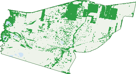
Green: 10 m cells where trees dominate, satellite 2021. Blue: water. The line is the suburb boundary.
| Canopy share, 1 m canopy height map, 2020 | 10.9% |
|---|---|
| Land with trees, 10 m satellite map, 2021 | 23.9% |
Demographics
Unemployment 11% · Labour-force participation 44.4%
Population by age in Morwell
| 0-4 | 821 |
|---|---|
| 5-14 | 1,678 |
| 15-19 | 764 |
| 20-24 | 870 |
| 25-34 | 1,772 |
| 35-44 | 1,503 |
| 45-54 | 1,761 |
| 55-64 | 1,960 |
| 65-74 | 1,746 |
| 75-84 | 1,050 |
| 85+ | 475 |
Dwelling types in Morwell
| House | 4,996 |
|---|---|
| Townhouse | 366 |
| Apartment | 425 |
| Other | 23 |
Households by weekly income in Morwell
| <$650 | 1,724 |
|---|---|
| $650-1,499 | 2,058 |
| $1,500-2,999 | 1,140 |
| $3,000+ | 416 |
Top ancestries in Morwell
| English | 5,217 |
|---|---|
| Australian | 4,939 |
| Ancestry NS | 1,730 |
| Scottish | 1,328 |
| Irish | 1,156 |
| Other | 993 |
Housing tenure in Morwell
| Owned | 2,157 |
|---|---|
| Mortgage | 1,449 |
| Rented | 1,962 |
| Other | 56 |
Cars per household in Morwell
| 0 | 584 |
|---|---|
| 1 | 2,494 |
| 2 | 1,795 |
| 3 | 511 |
| 4+ | 260 |
Commute to work in Morwell
| Car | 3,398 |
|---|---|
| Train | 12 |
| Bus | 45 |
| Tram/ferry | 0 |
| Walked | 100 |
| Bicycle | 24 |
| Home | 405 |
Top countries of birth in Morwell
| England | 347 |
|---|---|
| Italy | 280 |
| Philippines | 182 |
| India | 152 |
| New Zealand | 129 |
| Netherlands | 107 |
Languages used at home in Morwell
| Italian | 315 |
|---|---|
| Greek | 81 |
| Arabic | 69 |
| Malayalam | 68 |
| Tagalog | 66 |
| Mandarin | 56 |
Birds & Wildlife Nearby
12,379 bird observations recorded near Morwell — most often seen:
- Common Starling (747)
- Australian Magpie (672)
- Magpie-lark (668)
- Superb Fairy-wren (607)
- Welcome Swallow (553)
- Pacific Black Duck (548)
- Eurasian Blackbird (541)
- Red Wattlebird (476)
- White-faced Heron (468)
- Willie Wagtail (453)
- Australasian Purple Swamphen (417)
- European Goldfinch (411)
- Grey Fantail (393)
Show all 30 birds recorded near Morwell
- Little Raven (372)
- Eurasian Coot (371)
- Common Myna (354)
- Masked Lapwing (347)
- Australian White Ibis (336)
- Laughing Kookaburra (331)
- Grey Shrike-thrush (326)
- Black Swan (316)
- Little Pied Cormorant (311)
- Australian Wood Duck (307)
- Eastern Rosella (307)
- Black-shouldered Kite (306)
- Noisy Miner (305)
- New Holland Honeyeater (294)
- House Sparrow (291)
- Brown Thornbill (278)
- White-eared Honeyeater (273)
Sightings reported by observers, not a survey, so the counts show what people record rather than what lives here. Source: Atlas of Living Australia.
Nearby Suburbs
The closest suburbs to Morwell:
- Maryvale (4.5 km)
- Hazelwood North (7.5 km)
- Churchill (9.2 km)
- Hazelwood (9.2 km)
- Yallourn North (9.2 km)
- Hazelwood South (10.4 km)
- Driffield (10.4 km)
- Yallourn (10.6 km)
Embed this suburb
Add this free Morwell stat card to your own site — just copy the code:
Preview:
Cite this page
Quoting these figures? Copy the credit line:
Keep an eye on Morwell
One email when this data meaningfully changes — new census figures, prices, rankings. No spam, unsubscribe anytime.
Streets
- Therese Court (7)
- Tobruk Street (21)
- Tolmie Street (13)
- Toners Lane (7)
- Toombon Road (7)
- Toora Street (8)
- Tramway Road (10)
- Travers Street (27)
- Trent Court (11)
- Tulloch Street (26)
- Turnley Street (12)
- Urbahns Crescent (14)
- Valerie Court (4)
- Vary Street (174)
- Vasey Street (21)
- Veronica Court (3)
- Vestan Drive (29)
- Victor Street (11)
- Village Avenue (6)
- Vincent Road (135)
- Vindon Avenue (15)
- Viola Lane (9)
- Vision Street (16)
- Wallace Street (76)
- Waratah Drive (67)
- Washington Way (51)
- Watmor Avenue (13)
- Watt Street (8)
- Wattletree Crescent (37)
- Wedge Street (18)
- Wegner Street (5)
- Well Street (89)
- West Vale Drive (9)
- Whitby Avenue (12)
- White Street (18)
- Wicks Crescent (19)
- Williams Street (32)
- Willis Street (15)
- Willow Court (6)
- Wilson Street (14)
- Wingan Way (13)
- Winifred Street (50)
- Winston Court (12)
- Wonga Court (8)
- Woorarra Court (12)
- Wyung Drive (53)
- Yanakie Court (7)
- Yarak Court (12)