Tolmie VIC 3723
465 addresses · 31 streets
Indi Electorate › Mansfield LGA › Tolmie · 149 km from Melbourne

Living Here
Tolmie is a suburb of Victoria, home to about 547 people, with a median age of 52. The typical household earns around $1,353 a week, with median rent near $300 a week. Most homes are houses. About 91% of households own their home and 7% rent. Most workers drive to work. Common community backgrounds include English, Australian, Scottish. On the ABS socio-economic scale it sits in decile 6 of 10 nationally — a mid-range area.
Over time — Census 2001 → 2021
Dashed line: district figures for the Mansfield (Vic.) statistical area (SA2), the smallest area the ABS published before 2011. Solid line: Tolmie itself.
Getting Around & Local Services
1 Catholic church
Getting around. Airport: Benalla Airport, 48.4 km north-west.
Sport & Recreation
2 facilities recorded in Tolmie.
- Sawpit Circuit Cycling
- Tolmie Recreation reserve Tennis (Outdoor)
Socio-economic Standing
Deciles from 1 (lowest) to 10 (highest), against all Australian suburbs. The overall figure weighs advantage and disadvantage together; economic resources counts income and housing, and education & jobs counts qualifications and occupation. They often differ. Source: ABS SEIFA 2021.
Tree cover
🌳 Tree canopy: 85.6% share of land under canopy · satellite map, 2020
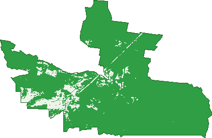
Green: 10 m cells where trees dominate, satellite 2021. Blue: water. The line is the suburb boundary.
| Canopy share, 1 m canopy height map, 2020 | 85.6% |
|---|---|
| Land with trees, 10 m satellite map, 2021 | 91.9% |
Demographics
Unemployment 2.8% · Labour-force participation 53%
Population by age in Tolmie
| 0-4 | 20 |
|---|---|
| 5-14 | 67 |
| 15-19 | 22 |
| 20-24 | 7 |
| 25-34 | 37 |
| 35-44 | 51 |
| 45-54 | 93 |
| 55-64 | 118 |
| 65-74 | 110 |
| 75-84 | 27 |
| 85+ | 0 |
Dwelling types in Tolmie
| House | 210 |
|---|---|
| Townhouse | 0 |
| Apartment | 0 |
| Other | 0 |
Households by weekly income in Tolmie
| <$650 | 31 |
|---|---|
| $650-1,499 | 69 |
| $1,500-2,999 | 58 |
| $3,000+ | 28 |
Top ancestries in Tolmie
| English | 232 |
|---|---|
| Australian | 190 |
| Scottish | 82 |
| Irish | 71 |
| Ancestry NS | 65 |
| German | 37 |
Housing tenure in Tolmie
| Owned | 102 |
|---|---|
| Mortgage | 94 |
| Rented | 14 |
| Other | 5 |
Cars per household in Tolmie
| 0 | 0 |
|---|---|
| 1 | 51 |
| 2 | 91 |
| 3 | 41 |
| 4+ | 29 |
Commute to work in Tolmie
| Car | 152 |
|---|---|
| Train | 0 |
| Bus | 0 |
| Tram/ferry | 0 |
| Walked | 6 |
| Bicycle | 0 |
| Home | 41 |
Top countries of birth in Tolmie
| England | 35 |
|---|---|
| New Zealand | 6 |
| Germany | 5 |
| Italy | 3 |
| United States | 3 |
Languages used at home in Tolmie
| Italian | 7 |
|---|---|
| Russian | 6 |
| German | 4 |
Birds & Wildlife Nearby
1,186 bird observations recorded near Tolmie — most often seen:
- Laughing Kookaburra (65)
- Crimson Rosella (60)
- White-throated Treecreeper (60)
- Brown Thornbill (59)
- Grey Shrike-thrush (58)
- Pied Currawong (56)
- Sulphur-crested Cockatoo (56)
- Red Wattlebird (54)
- Yellow-faced Honeyeater (54)
- Australian Magpie (53)
- Grey Fantail (50)
- White-browed Scrubwren (44)
- Eastern Yellow Robin (42)
Show all 30 birds recorded near Tolmie
- Silvereye (42)
- Superb Fairy-wren (39)
- Striated Thornbill (37)
- Spotted Pardalote (36)
- White-naped Honeyeater (35)
- Gang-gang Cockatoo (34)
- Striated Pardalote (30)
- Australian Raven (27)
- Australian Wood Duck (27)
- Superb Lyrebird (24)
- White-eared Honeyeater (22)
- Eastern Spinebill (21)
- Eastern Whipbird (21)
- Yellow-tailed Black-cockatoo (21)
- Australian King-parrot (20)
- Satin Bowerbird (20)
- Golden Whistler (19)
Sightings reported by observers, not a survey, so the counts show what people record rather than what lives here. Source: Atlas of Living Australia.
Nearby Suburbs
The closest suburbs to Tolmie:
- Archerton (4.9 km)
- Barwite (7.9 km)
- Bridge Creek (10.2 km)
- Cheshunt South (13.2 km)
- Whitlands (17.1 km)
- Merrijig (18.6 km)
- Mansfield (19.1 km)
- Cheshunt (20.2 km)
Embed this suburb
Add this free Tolmie stat card to your own site — just copy the code:
Preview:
Cite this page
Quoting these figures? Copy the credit line:
Keep an eye on Tolmie
One email when this data meaningfully changes — new census figures, prices, rankings. No spam, unsubscribe anytime.
Streets
- Altmans Road (15)
- Ambrose Drive (27)
- Bells Track (1)
- Blackwood Road (1)
- Bromfield Drive (21)
- Bunstons Road (58)
- Bushland Close (8)
- Cambatong Road (23)
- Candlebark Lane (5)
- Eucalypt Lane (6)
- Facey Drive (12)
- Faithfulls Road (4)
- Gears Hill Road (10)
- Healys Lane (1)
- Lavender Farm Road (8)
- Lowes Lane (5)
- Mansfield-whitfield Road (71)
- Masons Road (2)
- Merrifield Lane (1)
- Old Tolmie Road (63)
- Peppermint Lane (5)
- Reads Lane (1)
- Shane Lane (7)
- Spring Creek Road (19)
- Storers Lane (5)
- Tabletop Road (29)
- Tatong-tolmie Road (4)
- Tolmie-mahaikah Road (40)
- Wattle Court (9)
- Wattle Range Road (1)
- Wombat Lane (3)