Mansfield VIC 3722
4,488 addresses · 202 streets
Indi Electorate › Mansfield LGA › Mansfield · 130 km from Melbourne
📦 Thinking of moving here? Read the Mansfield moving guide

Living Here
Mansfield is a suburb of Victoria, home to about 5,541 people, with a median age of 47. The typical household earns around $1,356 a week, with median rent near $331 a week. Most homes are houses. About 75% of households own their home and 22% rent. Most workers drive to work. Common community backgrounds include English, Australian, Irish. On the ABS socio-economic scale it sits in decile 5 of 10 nationally — a mid-range area. The median house sells for about $750,000.
Over time — Census 2001 → 2021
Dashed line: district figures for the Mansfield (Vic.) statistical area (SA2), the smallest area the ABS published before 2011. Solid line: Mansfield itself.
Getting Around & Local Services
3 supermarkets
1 pharmacy
1 optometrist
1 hospital
1 library
1 post office
1 service station
4 gyms & sports centres
1 golf club
2 bakeries
1 butcher
2 hardware stores
1 hairdresser
Getting around. Bus interchange: Mansfield Passenger Terminal, 800 m north · Airport: Benalla Airport, 56.7 km north.
Sport & Recreation
15 facilities recorded in Mansfield, the first 10 below.
- Barwite Loop Cycling
- Benella Road Cycling
- Black & Tan Cycling
- Botanic Park Cricket
- Buller Road Circuit Cycling
- Groves ITT Cycling
- Lord Howes Circuit Cycling
- Lords Reserve Athletics, Cricket, Soccer
- Mansfield Bowls Club Lawn Bowls
- Mansfield Golf Club Golf
Socio-economic Standing
Deciles from 1 (lowest) to 10 (highest), against all Australian suburbs. The overall figure weighs advantage and disadvantage together; economic resources counts income and housing, and education & jobs counts qualifications and occupation. They often differ. Source: ABS SEIFA 2021.
Median Sale Prices
Median of recorded sales in the period, not a valuation. Source: Victorian Property Sales Report, Land Use Victoria.
Tree cover
🌳 Tree canopy: 9.6% share of land under canopy · satellite map, 2020
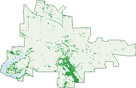
Green: 10 m cells where trees dominate, satellite 2021. Blue: water. The line is the suburb boundary.
| Canopy share, 1 m canopy height map, 2020 | 9.6% |
|---|---|
| Land with trees, 10 m satellite map, 2021 | 9.7% |
Demographics
Unemployment 1.8% · Labour-force participation 58.3%
Population by age in Mansfield
| 0-4 | 251 |
|---|---|
| 5-14 | 748 |
| 15-19 | 246 |
| 20-24 | 178 |
| 25-34 | 538 |
| 35-44 | 677 |
| 45-54 | 640 |
| 55-64 | 835 |
| 65-74 | 788 |
| 75-84 | 469 |
| 85+ | 182 |
Dwelling types in Mansfield
| House | 2,004 |
|---|---|
| Townhouse | 119 |
| Apartment | 8 |
| Other | 23 |
Households by weekly income in Mansfield
| <$650 | 426 |
|---|---|
| $650-1,499 | 659 |
| $1,500-2,999 | 610 |
| $3,000+ | 291 |
Top ancestries in Mansfield
| English | 2,387 |
|---|---|
| Australian | 2,253 |
| Irish | 853 |
| Scottish | 760 |
| Ancestry NS | 347 |
| Other | 311 |
Housing tenure in Mansfield
| Owned | 929 |
|---|---|
| Mortgage | 671 |
| Rented | 459 |
| Other | 61 |
Cars per household in Mansfield
| 0 | 81 |
|---|---|
| 1 | 711 |
| 2 | 833 |
| 3 | 326 |
| 4+ | 185 |
Commute to work in Mansfield
| Car | 1,706 |
|---|---|
| Train | 0 |
| Bus | 12 |
| Tram/ferry | 0 |
| Walked | 160 |
| Bicycle | 24 |
| Home | 330 |
Top countries of birth in Mansfield
| England | 179 |
|---|---|
| New Zealand | 61 |
| Germany | 47 |
| Scotland | 22 |
| Netherlands | 18 |
| Taiwan | 17 |
Languages used at home in Mansfield
| German | 47 |
|---|---|
| Mandarin | 25 |
| Urdu | 17 |
| Punjabi | 15 |
| French | 14 |
| Spanish | 10 |
Birds & Wildlife Nearby
14,672 bird observations recorded near Mansfield — most often seen:
- Australian Magpie (1,055)
- Sulphur-crested Cockatoo (889)
- Red Wattlebird (789)
- Crimson Rosella (785)
- Pied Currawong (724)
- Australian Wood Duck (627)
- Superb Fairy-wren (595)
- Pacific Black Duck (560)
- Common Starling (536)
- Weebill (529)
- Masked Lapwing (519)
- Galah (515)
- House Sparrow (487)
Show all 30 birds recorded near Mansfield
- Eurasian Blackbird (459)
- Laughing Kookaburra (437)
- Striated Pardalote (410)
- Grey Fantail (405)
- Little Corella (398)
- Magpie-lark (398)
- Eastern Rosella (380)
- Willie Wagtail (370)
- White-plumed Honeyeater (364)
- Australian White Ibis (349)
- Australian Raven (335)
- Red-browed Finch (317)
- Spotted Pardalote (317)
- Yellow-rumped Thornbill (295)
- Australian King-parrot (294)
- Eurasian Coot (277)
- Welcome Swallow (257)
Sightings reported by observers, not a survey, so the counts show what people record rather than what lives here. Source: Atlas of Living Australia.
Nearby Suburbs
The closest suburbs to Mansfield:
- Howes Creek (10.1 km)
- Delatite (11 km)
- Barwite (11.2 km)
- Maindample (12.3 km)
- Bridge Creek (12.4 km)
- Piries (12.5 km)
- Goughs Bay (13 km)
- Mountain Bay (13.3 km)
Embed this suburb
Add this free Mansfield stat card to your own site — just copy the code:
Preview:
Cite this page
Quoting these figures? Copy the credit line:
Keep an eye on Mansfield
One email when this data meaningfully changes — new census figures, prices, rankings. No spam, unsubscribe anytime.
Streets
- Acacia Close (8)
- Adams Street (12)
- Ailsa Street (74)
- Aldous Road (6)
- Amor Drive (9)
- Amy Court (8)
- Apollo Street (20)
- Aspect Rise (1)
- Avoca Court (12)
- Baalwick Court (4)
- Baldry Street (38)
- Bank Place (4)
- Banksia Street (20)
- Banumum Road (33)
- Barwite Road (10)
- Bellview Court (39)
- Bimbadeen Way (6)
- Bluff Court (8)
- Box Court (11)
- Bretts Road (2)
- Broadbent Court (8)
- Bundjil Drive (12)
- Cambridge Drive (128)
- Campagnolos Road (35)
- Campbells Lane (5)
- Carlisle Hill Road (1)
- Carob Court (11)
- Casuarina Close (7)
- Chenery Street (76)
- Church Street (4)
- Clarke Street (10)
- Cloverdale Court (12)
- Club Court (20)
- Cockatoo Court (5)
- College Lane (4)
- Collie Court (8)
- Collopy Street (45)
- Coonara Court (4)
- Cricket Street (21)
- Crosbys Lane (58)
- Cummins Road (15)
- Curia Street (49)
- Davies Street (13)
- Dead Horse Lane (79)
- Dianella Court (9)
- Donovans Way (66)
- Douglas Street (2)
- Drakes Hill Road (19)
- Drovers Court (7)
- Dueran Lane (10)
- Dundas Court (14)
- Early Street (19)
- Eisners Lane (5)
- Elm Court (6)
- Elm Place (6)
- Elvins Street (55)
- Erril Street (14)
- Farrall Court (12)
- Fentons Lane (2)
- Finlason Street (41)
- Ford Drive (38)
- Galway Court (9)
- Glencoe Ridge (3)
- Glenroy Road (23)
- Godwills Road (10)
- Goulburn Drive (8)
- Graves Road (17)
- Greenfields Way (10)
- Greenslopes Avenue (31)
- Greenvale Lane (21)
- Griffin Avenue (24)
- Grimwade Lane (4)
- Hallets Lane (3)
- Harrison Drive (7)
- Harvest Street (2)
- Hearns Road (2)
- High Street (189)
- High Vista Court (6)
- Highett Street (138)
- Highlands Road (39)
- Highton Lane (233)
- Hill Court (20)
- Hillton Court (9)
- Hollams Road (10)
- Howes Creek Road (107)
- Hunter Street (81)
- Ingomar Road (1)
- James Street (9)
- Jenny Court (13)
- Kareen Court (12)
- Kate Court (10)
- Keally Court (4)
- Kelson Street (1)
- Kennedy Court (5)
- Kent Court (21)
- Kerry Court (14)
- Kidston Parade (39)
- Kilkenny Court (14)
- Kilmuir Lane (1)
- Kitchen Street (49)
- Lakins Road (11)
- Lawsons Lane (9)
- Lehman Lane (3)
- Lily Court (6)
- Links Road (33)
- Little Scullys Lane (2)
- Loch Street (4)
- Logan Street (24)
- Lomandra Way (20)
- Long Lane (26)
- Lovick Avenue (37)
- Loyola Drive (15)
- Macpherson Smith Drive (24)
- Malcolm Street (213)
- Mansfield-whitfield Road (10)
- Mansfield-woods Point Road (22)
- Maple Tree Boulevard (23)
- Maroondah Highway (24)
- Mayfair Grove (24)
- Mcdonald Street (22)
- Mcelroy Lane (5)
- Mcleod Lane (19)
- Mcmillan Point Drive (16)
- Merinda Way (30)
- Midland Highway (32)
- Mimamiluke Court (4)
- Minerva Street (24)
- Mitchell Court (30)
- Monkey Gully Road (58)
- Moorey Street (7)
- Mt Battery Road (59)
- Mt Buller Road (57)
- Mulong Drive (4)
- Murphy Street (22)
- New Street (25)
- Nolan Street (18)
- Oakbank Court (8)
- Oaksford Drive (24)
- Ogilvies Road (36)
- Ohalloran Road (14)
- Ohanlon Road (16)
- Old Howes Creek Road (8)
- Old Mill Road (27)
- Old Tolmie Road (6)
- Old Tonga Road (29)
- Olive Grove Court (5)
- Olivers Road (8)
- Olympic Street (11)
- Owens Creek Drive (20)
- Panorama Terrace (12)
- Paps Lane (3)
- Parwanoff Street (7)
- Paxtons Lane (10)
- Peak Court (26)
- Pikes Road (4)
- Pollards Road (16)
- Prest Court (8)
- Preston Court (4)
- Quarry Lane (7)
- Range View Court (12)
- Ray Street (2)
- Reardon Lane (11)
- Redgum Drive (62)
- Redhill Court (1)
- Redleaf Court (16)
- Reynolds Street (29)
- Rifle Butts Road (35)
- Rowe Street (34)
- Ryan Street (8)
- Saddle Court (12)
- Sadie Court (8)
- Sarah Court (8)
- Scenic Drive (14)
- Scullys Lane (5)
- Shamrock Lane (2)
- Sian Close (11)
- Smada Crescent (11)
- Somerset Crescent (66)
- Sovereign Court (9)
- Station Street (6)
- Stewart Street (35)
- Stock Route (5)
- Stockmans Drive (14)
- Stoneleigh Road (51)
- Stoneys Road (2)
- Stringybark Street (13)
- Sweeney Court (12)
- Table Top Road (5)
- Tannin Lane (22)
- Terry Road (2)
- The Parade (35)
- The Point (7)
- Tilia Court (11)
- Timothy Lane (7)
- Tin Hut Lane (2)
- Ultimo Street (21)
- Victoria Street (32)
- View Street (17)
- Village Court (13)
- Walker Street (7)
- Williams Drive (41)
- Withers Lane (22)