St Leonards VIC 3223
5,828 addresses · 176 streets
Corangamite Electorate › Greater Geelong LGA › St Leonards · 46 km from Melbourne
📦 Thinking of moving here? Read the St Leonards moving guide

Living Here
St Leonards is a suburb of Victoria, home to about 3,542 people, with a median age of 56. The typical household earns around $1,183 a week, with median rent near $350 a week. Most homes are houses. About 74% of households own their home and 24% rent. Most workers drive to work. Common community backgrounds include English, Australian, Irish. On the ABS socio-economic scale it sits in decile 4 of 10 nationally — a mid-range area. The median house sells for about $720,000.
Over time — Census 2001 → 2021
Dashed line: district figures for the Portarlington statistical area (SA2), the smallest area the ABS published before 2011. Solid line: St Leonards itself.
Getting Around & Local Services
1 school
4 cafés & restaurants
1 supermarket
1 beach
1 pharmacy
1 post office
1 gym
2 golf clubs
1 bakery
1 hardware store
2 hairdressers
1 electrician
Getting around. Airport: Avalon Airport, 25.9 km north-west.
Sport & Recreation
6 facilities recorded in St Leonards.
- Harvey Park Tennis (Outdoor)
- Len Trewin Reserve Bocce, Cricket, Soccer, Tennis (Outdoor)
- Leviens Reserve (Charles McCarthy res.) Cricket
- St Leonards Bowling Club Lawn Bowls
- St Leonards Lake Reserve Cricket, Soccer
- St Leonards Yacht Club & Motor Squadron Sailing
Socio-economic Standing
Deciles from 1 (lowest) to 10 (highest), against all Australian suburbs. The overall figure weighs advantage and disadvantage together; economic resources counts income and housing, and education & jobs counts qualifications and occupation. They often differ. Source: ABS SEIFA 2021.
Median Sale Prices
Median of recorded sales in the period, not a valuation. Source: Victorian Property Sales Report, Land Use Victoria.
Tree cover
🌳 Tree canopy: 8.6% share of land under canopy · satellite map, 2020
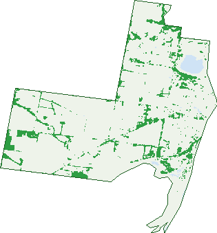
Green: 10 m cells where trees dominate, satellite 2021. Blue: water. The line is the suburb boundary.
| Canopy share, 1 m canopy height map, 2020 | 8.6% |
|---|---|
| Land with trees, 10 m satellite map, 2021 | 10.8% |
Demographics
Unemployment 5.1% · Labour-force participation 45.8%
Population by age in St Leonards
| 0-4 | 131 |
|---|---|
| 5-14 | 266 |
| 15-19 | 112 |
| 20-24 | 108 |
| 25-34 | 318 |
| 35-44 | 308 |
| 45-54 | 458 |
| 55-64 | 675 |
| 65-74 | 759 |
| 75-84 | 328 |
| 85+ | 81 |
Dwelling types in St Leonards
| House | 1,436 |
|---|---|
| Townhouse | 109 |
| Apartment | 8 |
| Other | 0 |
Households by weekly income in St Leonards
| <$650 | 349 |
|---|---|
| $650-1,499 | 549 |
| $1,500-2,999 | 407 |
| $3,000+ | 170 |
Top ancestries in St Leonards
| English | 1,411 |
|---|---|
| Australian | 1,255 |
| Irish | 463 |
| Scottish | 417 |
| Ancestry NS | 223 |
| Italian | 201 |
Housing tenure in St Leonards
| Owned | 758 |
|---|---|
| Mortgage | 387 |
| Rented | 369 |
| Other | 28 |
Cars per household in St Leonards
| 0 | 44 |
|---|---|
| 1 | 569 |
| 2 | 671 |
| 3 | 172 |
| 4+ | 80 |
Commute to work in St Leonards
| Car | 816 |
|---|---|
| Train | 3 |
| Bus | 8 |
| Tram/ferry | 0 |
| Walked | 18 |
| Bicycle | 6 |
| Home | 316 |
Top countries of birth in St Leonards
| England | 161 |
|---|---|
| New Zealand | 58 |
| Italy | 57 |
| Greece | 50 |
| Malta | 35 |
| Scotland | 27 |
Languages used at home in St Leonards
| Greek | 81 |
|---|---|
| Italian | 62 |
| French | 13 |
| Croatian | 12 |
| Vietnamese | 11 |
| Spanish | 9 |
Birds & Wildlife Nearby
27,655 bird observations recorded near St Leonards — most often seen:
- Silver Gull (1,325)
- Superb Fairy-wren (1,298)
- Red Wattlebird (1,231)
- Little Raven (1,176)
- Australian Pelican (1,155)
- Welcome Swallow (1,108)
- New Holland Honeyeater (1,098)
- Little Pied Cormorant (1,085)
- White-faced Heron (1,068)
- Eurasian Blackbird (1,003)
- Spiny-cheeked Honeyeater (1,003)
- Common Starling (990)
- Grey Fantail (962)
Show all 30 birds recorded near St Leonards
- Australian White Ibis (951)
- Australian Magpie (910)
- Brown Thornbill (908)
- Masked Lapwing (900)
- Magpie-lark (829)
- Chestnut Teal (820)
- Silvereye (798)
- Black Swan (785)
- Pied Cormorant (768)
- Willie Wagtail (737)
- Red-capped Plover (705)
- Galah (703)
- Straw-necked Ibis (691)
- Pacific Gull (690)
- Spotted Turtle-dove (687)
- Crested Tern (663)
- Australian Pied Oystercatcher (608)
Sightings reported by observers, not a survey, so the counts show what people record rather than what lives here. Source: Atlas of Living Australia.
Nearby Suburbs
The closest suburbs to St Leonards:
- Indented Head (4.6 km)
- Swan Bay (7.2 km)
- Portarlington (8.3 km)
- Swan Island (8.5 km)
- Bellarine (8.8 km)
- Mannerim (10.2 km)
- Queenscliff (11.3 km)
- Drysdale (11.9 km)
Embed this suburb
Add this free St Leonards stat card to your own site — just copy the code:
Preview:
Cite this page
Quoting these figures? Copy the credit line:
Keep an eye on St Leonards
One email when this data meaningfully changes — new census figures, prices, rankings. No spam, unsubscribe anytime.
Streets
- Ainsley Court (9)
- Amelia Place (2)
- Anchor Court (7)
- Annmaree Drive (12)
- Armstrong Walk (25)
- Arvon Court (7)
- Bartail Street (5)
- Bartail Way (9)
- Bayse Street (8)
- Bayside Avenue (45)
- Bayview Avenue (7)
- Beach Road (47)
- Bell Parade (25)
- Birdwood Drive (55)
- Black Swan Drive (76)
- Blanche Street (108)
- Bluebill Street (20)
- Bluff Road (366)
- Bosca Lane (3)
- Calk Terrace (22)
- Canara Mews (5)
- Centreway Road (32)
- Chaffey Court (10)
- Charles Court (7)
- Chestnut Way (6)
- Cliff Court (9)
- Cliff Street (74)
- Clyde Avenue (50)
- Coatsworth Avenue (44)
- Cole Street (17)
- Coles Close (6)
- Collett Court (12)
- Cope Court (4)
- Cope Place (3)
- Cormorant Drive (28)
- Countess Drive (120)
- Davenish Way (22)
- Denholm Place (2)
- Denholm Street (34)
- Devenish Way (22)
- Dominico Street (21)
- Doongara Avenue (43)
- Dossetor Road (31)
- Duchess Drive (68)
- Dudley Parade (80)
- Dune Street (12)
- Dunstan Street (12)
- Edith Court (16)
- Edwards Point Road (33)
- Elegante Road (25)
- Elise Street (8)
- Emu Street (4)
- Fairview Street (9)
- Felix Street (30)
- Findlay Avenue (23)
- First Avenue (14)
- Fitzwalter Street (21)
- Flathead Place (3)
- Flinders Road (18)
- Gallant Road (48)
- Gamble Way (72)
- Gardner Court (11)
- Garfish Place (2)
- Garner Lane (25)
- Gemstone Street (16)
- Georgina Avenue (19)
- Gibson Grove (27)
- Gilbert Street (58)
- Godwit Place (4)
- Golf View Street (8)
- Grassy Point Road (2)
- Halyard Terrace (9)
- Harbour Way (22)
- Harrington Terrace (48)
- Harvey Road (108)
- Henry Crescent (7)
- Henty Road (23)
- Holden Court (6)
- Hopetoun Street (22)
- Horne Avenue (34)
- Howard Street (19)
- Ibbotson Street (91)
- Ibis Circuit (16)
- Ibis Road (4)
- Jacana Drive (30)
- Janvrin Road (8)
- Jelly Junction (21)
- Jules Street (21)
- Kabiri Terrace (24)
- Kane Drive (55)
- King George Street (49)
- Lake View Crescent (63)
- Laura Lane (1)
- Leatherjacket Place (2)
- Leonard Street (32)
- Leviens Road (176)
- Lower Bluff Road (1)
- Mainsail Drive (63)
- Majestic Way (45)
- Manifold Road (12)
- Manning Street (32)
- Margaret Street (17)
- Marina Road (18)
- Mariners Street (30)
- Martinsen Street (5)
- Masters Place (2)
- Matilda Street (19)
- Mcbeth Street (6)
- Mcinnes Way (18)
- Mcleod Street (15)
- Meredith Avenue (23)
- Meredith Street (23)
- Miranda Crescent (85)
- Monaco Avenue (20)
- Monahan Drive (23)
- Moreland Road (11)
- Mouchemore Avenue (44)
- Murradoc Road (218)
- Narvik Avenue (45)
- Norfolk Street (1)
- Ocean Mist Court (18)
- Old St Leonards Road (77)
- Ord Street (35)
- Owl Street (17)
- Palace Road (19)
- Pardolote Crescent (39)
- Paton Street (11)
- Paywit Street (31)
- Pearl Bay Passage (95)
- Phillip Court (6)
- Port Deakin Street (22)
- Queenscliff Road (13)
- Reardon Crescent (46)
- Regal Road (27)
- Rhonda Avenue (17)
- Rigby Street (61)
- Robinson Street (22)
- Salt Water Drive (19)
- Saltmarsh Way (5)
- Sandbar Street (17)
- Seabrook Crescent (22)
- Seachange Way (45)
- Seacrest Walk (18)
- Seaview Avenue (42)
- Second Avenue (22)
- Shoppee Court (6)
- Sparrowhawk Road (84)
- Spinnaker Drive (18)
- Spoonbill Street (24)
- St Leonards Parade (46)
- Starboard Court (7)
- Stilt Road (19)
- Sunrise Crescent (9)
- Swain Walk (18)
- Swan Parade (32)
- Sylvester Avenue (21)
- Sylwen Parade (1)
- Tanker View Rise (16)
- Teal Place (2)
- Tess Court (7)
- The Esplanade (134)
- The Foreshore (23)
- Thomson Boulevard (42)
- Thornton Avenue (463)
- Trewin Street (2)
- Trilby Avenue (18)
- Turnberry Close (25)
- Two Bays Drive (26)
- Ward Street (100)
- Waters Way (10)
- Wattlehill Grove (57)
- Wattletree Avenue (42)
- Wave Street (11)
- Weeroona Street (5)
- Wenham Way (4)
- Whipbird Way (15)