Drysdale VIC 3222
3,824 addresses · 157 streets
Corangamite Electorate › Greater Geelong LGA › Drysdale · 53 km from Melbourne
📦 Thinking of moving here? Read the Drysdale moving guide

Living Here
Drysdale is a suburb of Victoria, home to about 4,976 people, with a median age of 52. The typical household earns around $1,273 a week, with median rent near $340 a week. Most homes are houses. About 79% of households own their home and 16% rent. Most workers drive to work. Common community backgrounds include English, Australian, Irish. On the ABS socio-economic scale it sits in decile 5 of 10 nationally — a mid-range area. The median house sells for about $685,000.
Over time — Census 2001 → 2021
Dashed line: district figures for the Clifton Springs statistical area (SA2), the smallest area the ABS published before 2011. Solid line: Drysdale itself.
Getting Around & Local Services
3 cafés & restaurants
3 supermarkets
1 medical clinic
1 childcare centre
1 library
1 post office
2 service stations
1 hairdresser
2 mechanics
1 electrician
2 places to stay
Getting around. Railway halt: Drysdale, 1.4 km south-west · Airport: Avalon Airport, 17.6 km north-west.
Sport & Recreation
5 facilities recorded in Drysdale.
- Curves Drysdale Fitness / Gymnasium Workouts
- Drysdale bowls Clubs Croquet, Lawn Bowls
- Drysdale Recreation Reserve Australian Rules Football, Cricket, Netball, Tennis (Outdoor)
- Lake Lorne reserve Equestrian
- Wathaurung Reserve Tennis (Outdoor)
Socio-economic Standing
Deciles from 1 (lowest) to 10 (highest), against all Australian suburbs. The overall figure weighs advantage and disadvantage together; economic resources counts income and housing, and education & jobs counts qualifications and occupation. They often differ. Source: ABS SEIFA 2021.
Median Sale Prices
Median of recorded sales in the period, not a valuation. Source: Victorian Property Sales Report, Land Use Victoria.
Tree cover
🌳 Tree canopy: 5.6% share of land under canopy · satellite map, 2020
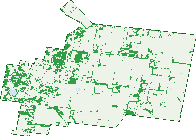
Green: 10 m cells where trees dominate, satellite 2021. Blue: water. The line is the suburb boundary.
| Canopy share, 1 m canopy height map, 2020 | 5.6% |
|---|---|
| Land with trees, 10 m satellite map, 2021 | 15.1% |
Demographics
Unemployment 4.1% · Labour-force participation 50.8%
Population by age in Drysdale
| 0-4 | 170 |
|---|---|
| 5-14 | 576 |
| 15-19 | 277 |
| 20-24 | 212 |
| 25-34 | 357 |
| 35-44 | 459 |
| 45-54 | 568 |
| 55-64 | 698 |
| 65-74 | 853 |
| 75-84 | 543 |
| 85+ | 254 |
Dwelling types in Drysdale
| House | 1,775 |
|---|---|
| Townhouse | 194 |
| Apartment | 32 |
| Other | 0 |
Households by weekly income in Drysdale
| <$650 | 400 |
|---|---|
| $650-1,499 | 652 |
| $1,500-2,999 | 493 |
| $3,000+ | 314 |
Top ancestries in Drysdale
| English | 2,399 |
|---|---|
| Australian | 1,891 |
| Irish | 668 |
| Scottish | 646 |
| Other | 230 |
| German | 217 |
Housing tenure in Drysdale
| Owned | 949 |
|---|---|
| Mortgage | 606 |
| Rented | 318 |
| Other | 87 |
Cars per household in Drysdale
| 0 | 84 |
|---|---|
| 1 | 732 |
| 2 | 718 |
| 3 | 246 |
| 4+ | 184 |
Commute to work in Drysdale
| Car | 1,318 |
|---|---|
| Train | 8 |
| Bus | 4 |
| Tram/ferry | 3 |
| Walked | 49 |
| Bicycle | 3 |
| Home | 349 |
Top countries of birth in Drysdale
| England | 306 |
|---|---|
| New Zealand | 61 |
| Netherlands | 36 |
| Scotland | 33 |
| Germany | 29 |
| South Africa | 25 |
Languages used at home in Drysdale
| Italian | 30 |
|---|---|
| Malayalam | 18 |
| German | 11 |
| Spanish | 11 |
| Thai | 10 |
| Mandarin | 9 |
Birds & Wildlife Nearby
54,694 bird observations recorded near Drysdale — most often seen:
- Chestnut Teal (2,409)
- Magpie-lark (2,381)
- Pacific Black Duck (2,244)
- Red Wattlebird (2,242)
- Eurasian Coot (2,228)
- Little Raven (2,144)
- Common Starling (2,124)
- Superb Fairy-wren (1,971)
- Eurasian Blackbird (1,942)
- Australian Wood Duck (1,928)
- Noisy Miner (1,918)
- Australian Magpie (1,873)
- Black Swan (1,833)
Show all 30 birds recorded near Drysdale
- Little Pied Cormorant (1,829)
- Australian White Ibis (1,802)
- Hoary-headed Grebe (1,789)
- Australasian Purple Swamphen (1,775)
- Dusky Moorhen (1,740)
- Welcome Swallow (1,739)
- Grey Teal (1,714)
- Straw-necked Ibis (1,660)
- Masked Lapwing (1,586)
- New Holland Honeyeater (1,567)
- Blue-billed Duck (1,537)
- Willie Wagtail (1,533)
- Common Myna (1,501)
- Eastern Rosella (1,461)
- Freckled Duck (1,452)
- Rainbow Lorikeet (1,398)
- Spotted Turtle-dove (1,374)
Sightings reported by observers, not a survey, so the counts show what people record rather than what lives here. Source: Atlas of Living Australia.
Nearby Suburbs
The closest suburbs to Drysdale:
- Clifton Springs (1.8 km)
- Curlewis (2.3 km)
- Mannerim (5.7 km)
- Bellarine (5.8 km)
- Wallington (6.9 km)
- Marcus Hill (7.4 km)
- Swan Bay (8.7 km)
- Portarlington (9.2 km)
Embed this suburb
Add this free Drysdale stat card to your own site — just copy the code:
Preview:
Cite this page
Quoting these figures? Copy the credit line:
Keep an eye on Drysdale
One email when this data meaningfully changes — new census figures, prices, rankings. No spam, unsubscribe anytime.
Streets
- Andersons Road (32)
- Ashworth Street (4)
- Banks Road (4)
- Barrands Lane (107)
- Basin Road (6)
- Bayvista Parade (17)
- Becks Road (8)
- Belchers Road (10)
- Bellarine Rail Trail (2)
- Benham Street (2)
- Bennett Street (42)
- Brianna Place (2)
- Bridge Street (20)
- Buccleugh Street (44)
- Buick Mews (14)
- Carolanne Drive (78)
- Carriage Crescent (2)
- Carrs Lane (7)
- Cemetery Road (22)
- Central Road (19)
- Chevy Avenue (16)
- Chivers Place (3)
- Clarendon Road (67)
- Clifton Springs Road (177)
- Collins Street (157)
- Community Drive (2)
- Condy Street (15)
- Connors Road (4)
- Cowies Road (3)
- Crimea Street (23)
- Cullen Court (10)
- David Street (24)
- Daylesford Lane (8)
- De Burgh Road (58)
- Deacon Court (22)
- Diana Court (18)
- Dodge Drive (4)
- Dorton Glade (21)
- Drakes Road (27)
- Duke Street (41)
- East Street (5)
- Eastwood Crescent (33)
- Edessa Crescent (11)
- Elgin Street (61)
- Epsom View (12)
- Ernstine Way (25)
- Eversley Street (15)
- Fairview Court (15)
- Farmhouse Avenue (45)
- Filbay Crescent (14)
- Flinders View Drive (6)
- Founds Road (27)
- Franklin Way (5)
- Gilchrist Street (1)
- Gillies Road (5)
- Glengarry Court (31)
- Granville Street (30)
- Grubb Road (9)
- Gumleaf Place (3)
- Hackwill Place (3)
- Hancock Street (23)
- Harold Court (9)
- Harrison Rise (24)
- Harrogate Lane (14)
- Hastings Way (5)
- Hepburn Way (7)
- Heritage Mews (33)
- High Street (202)
- Humber Way (12)
- Huntingdon Street (28)
- Hutchinson Court (6)
- Indigo Place (4)
- James Court (15)
- Jetty Road (27)
- Jirakee Way (1)
- Jones Road (4)
- Jurgens Road (5)
- Kilby Court (4)
- Kimberley Avenue (33)
- Kooroui Court (5)
- Landsdale Court (13)
- Lauriston Lane (8)
- Lenerin Place (7)
- Lennox Court (10)
- Leonard Drive (24)
- Macauley Way (18)
- Madison Court (3)
- Marsh Court (28)
- Martins Road (8)
- Mataranka Grove (27)
- Mayall Way (6)
- Mckenzie Street (1)
- Mckiernan Street (9)
- Meadowbrook Terrace (18)
- Meridan Way (5)
- Meridian Way (3)
- Mortimer Street (11)
- Mouldens Lane (1)
- Murradoc Road (212)
- Nash Avenue (33)
- Newcombe Street (65)
- Newfields Drive (50)
- Oakden Road (21)
- Oakland Drive (16)
- Okeefe Court (7)
- Palmerston Street (45)
- Pandora Court (6)
- Pandora Road (6)
- Pascoe Place (5)
- Patricia Court (13)
- Peninsula Drive (9)
- Peppermint Grove (14)
- Platinum Avenue (30)
- Portarlington Road (65)
- Princess Street (124)
- Queenscliff Road (3)
- Railway Crescent (3)
- Redgum Place (6)
- Reef Place (3)
- Regency Crescent (18)
- Regency Drive (19)
- Reserve Road (13)
- Reservoir Road (4)
- Ridley Street (40)
- Rowe Court (14)
- Ryan Court (16)
- Ryder Court (8)
- Saratoga Circuit (56)
- Scotchmans Road (24)
- Serene Terrace (61)
- Settlement Road N (6)
- Settlement Road S (4)
- Sheileen Court (3)
- Soho Road (12)
- Sproat Street (13)
- Station Street (41)
- Stonebridge Road (51)
- Stonehouse Place (1)
- Sutton Way (6)
- Tenbury Wells Avenue (51)
- Terry Court (7)
- The Glen (24)
- Thomas Street (4)
- Tony Street (28)
- Torno Court (27)
- Tranquil Terrace (12)
- Turquoise Place (4)
- Viewside Circuit (67)
- Vron Place (6)
- Waterhaven Boulevard (14)
- Waterson Place (5)
- Waterway Court (11)
- Whitcombes Road (35)
- Wisbey Court (17)
- Woodville Street (45)
- Wyndham Street (159)
- Zoe Lane (3)