Seaford VIC 3198
11,674 addresses · 249 streets
Dunkley Electorate › Frankston LGA › Seaford · 36 km from Melbourne
📦 Thinking of moving here? Read the Seaford moving guide

Living Here
A bayside south-eastern Melbourne suburb between Frankston and Carrum, Seaford offers a beach lifestyle at relatively accessible prices. Households average 2.3 people and the median age is 40. Median household income is $1,500 a week, with rent around $351.
Seaford is a suburb of Victoria, home to about 17,215 people, with a median age of 40. The typical household earns around $1,500 a week, with median rent near $351 a week. Most homes are houses. About 64% of households own their home and 33% rent. Most workers drive to work. Common community backgrounds include English, Australian, Irish. On the ABS socio-economic scale it sits in decile 5 of 10 nationally — a mid-range area. The median house sells for about $842,000.
Over time — Census 2001 → 2021
Dashed line: district figures for the Seaford (Vic.) statistical area (SA2), the smallest area the ABS published before 2011. Solid line: Seaford itself.
Getting Around & Local Services
2 beaches
2 Catholic churches
2 pharmacies
4 doctors & medical clinics
3 optometrists
1 playground
2 dog parks
3 bakeries
3 hairdressers
3 beauty salons
1 carpenter
Getting around. Train station: Seaford, 950 m north-west · Airport: Moorabbin Airport, 14.9 km north.
Sport & Recreation
19 facilities recorded in Seaford, the first 10 below.
- Beachside Fitness Centre Seaford Fitness / Gymnasium Workouts
- Belvedere Park Tennis Club Tennis (Outdoor)
- Belvedere Reserve Australian Rules Football, Cricket
- Carrum Bowling Club Lawn Bowls
- Crystal park Tennis (Outdoor)
- East Seaford Reserve (Norm Cathie Oval) Australian Rules Football, Cricket
- Energym Health & Fitness Fitness / Gymnasium Workouts
- Frankston Basketball Stadium Basketball
- Frankston Indoor Sports Beach Volleyball, Cricket (Indoor), Netball (Indoor), Soccer (Indoor Soccer / Futsal)
- Frankston Motocycle & BMX Club BMX, Motor Sports
Socio-economic Standing
Deciles from 1 (lowest) to 10 (highest), against all Australian suburbs. The overall figure weighs advantage and disadvantage together; economic resources counts income and housing, and education & jobs counts qualifications and occupation. They often differ. Source: ABS SEIFA 2021.
Median Sale Prices
Median of recorded sales in the period, not a valuation. Source: Victorian Property Sales Report, Land Use Victoria.
Tree cover
🌳 Tree canopy: 16.8% share of land under canopy · satellite map, 2020
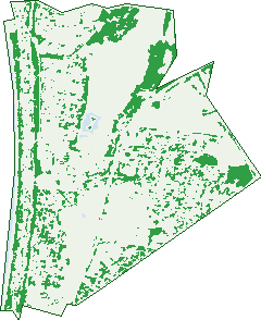
Green: 10 m cells where trees dominate, satellite 2021. Blue: water. The line is the suburb boundary.
| Canopy share, 1 m canopy height map, 2020 | 16.8% |
|---|---|
| Land with trees, 10 m satellite map, 2021 | 19.4% |
Demographics
Unemployment 5% · Labour-force participation 61.6%
Population by age in Seaford
| 0-4 | 1,179 |
|---|---|
| 5-14 | 1,853 |
| 15-19 | 783 |
| 20-24 | 802 |
| 25-34 | 2,352 |
| 35-44 | 2,682 |
| 45-54 | 2,445 |
| 55-64 | 2,036 |
| 65-74 | 1,682 |
| 75-84 | 1,016 |
| 85+ | 385 |
Dwelling types in Seaford
| House | 5,295 |
|---|---|
| Townhouse | 1,666 |
| Apartment | 182 |
| Other | 43 |
Households by weekly income in Seaford
| <$650 | 1,345 |
|---|---|
| $650-1,499 | 2,010 |
| $1,500-2,999 | 2,132 |
| $3,000+ | 1,233 |
Top ancestries in Seaford
| English | 7,040 |
|---|---|
| Australian | 6,052 |
| Irish | 2,208 |
| Scottish | 1,955 |
| Other | 1,569 |
| Ancestry NS | 1,103 |
Housing tenure in Seaford
| Owned | 1,978 |
|---|---|
| Mortgage | 2,544 |
| Rented | 2,368 |
| Other | 188 |
Cars per household in Seaford
| 0 | 518 |
|---|---|
| 1 | 2,939 |
| 2 | 2,662 |
| 3 | 662 |
| 4+ | 284 |
Commute to work in Seaford
| Car | 4,807 |
|---|---|
| Train | 122 |
| Bus | 45 |
| Tram/ferry | 0 |
| Walked | 77 |
| Bicycle | 40 |
| Home | 1,900 |
Top countries of birth in Seaford
| England | 860 |
|---|---|
| New Zealand | 402 |
| Scotland | 136 |
| Germany | 134 |
| China | 117 |
| Ireland | 102 |
Languages used at home in Seaford
| Greek | 158 |
|---|---|
| Russian | 126 |
| Mandarin | 121 |
| Spanish | 102 |
| Italian | 95 |
| German | 76 |
Birds & Wildlife Nearby
81,972 bird observations recorded near Seaford — most often seen:
- Eurasian Blackbird (4,705)
- Common Myna (4,639)
- Common Starling (4,583)
- Little Raven (4,506)
- Spotted Turtle-dove (3,146)
- Pacific Black Duck (3,109)
- Rainbow Lorikeet (2,994)
- Magpie-lark (2,977)
- Australian Magpie (2,889)
- Chestnut Teal (2,854)
- Noisy Miner (2,829)
- Red Wattlebird (2,770)
- Southern Victoria Australian Magpie (2,502)
Show all 30 birds recorded near Seaford
- European Goldfinch (2,484)
- Silver Gull (2,472)
- Superb Fairy-wren (2,389)
- White-faced Heron (2,381)
- Welcome Swallow (2,377)
- Black Swan (2,343)
- Southern Magpie-lark (2,319)
- Australasian Purple Swamphen (2,311)
- House Sparrow (2,293)
- Willie Wagtail (2,239)
- Eastern Asian Spotted Dove (2,213)
- Northern Superb Fairy-wren (2,005)
- Crested Pigeon (1,981)
- Southern Willie Wagtail (1,954)
- Swamp Harrier (1,923)
- Eastern Red Wattlebird (1,911)
- Grey Butcherbird (1,874)
Sightings reported by observers, not a survey, so the counts show what people record rather than what lives here. Source: Atlas of Living Australia.
Nearby Suburbs
The closest suburbs to Seaford:
- Frankston North (2.1 km)
- Carrum (3.7 km)
- Carrum Downs (3.9 km)
- Frankston (4.3 km)
- Patterson Lakes (4.4 km)
- Bonbeach (5.3 km)
- Skye (5.4 km)
- Sandhurst (6.7 km)
Embed this suburb
Add this free Seaford stat card to your own site — just copy the code:
Preview:
Cite this page
Quoting these figures? Copy the credit line:
Keep an eye on Seaford
One email when this data meaningfully changes — new census figures, prices, rankings. No spam, unsubscribe anytime.
Streets
- Abeckett Street (35)
- Admans Avenue (38)
- Airlie Grove (50)
- Andrew Street (3)
- Anthony Court (7)
- Apsley Place (54)
- Arden Court (15)
- Armstrongs Road (85)
- Arthur Street (22)
- Ashworth Drive (21)
- Attunga Crescent (31)
- Austin Road (311)
- Bainbridge Avenue (82)
- Bambra Court (6)
- Bardia Avenue (91)
- Barry Street (97)
- Bayside Grove (45)
- Beach Grove (27)
- Beckwith Grove (15)
- Bellevue Crescent (37)
- Belvedere Road (44)
- Benelong Crescent (30)
- Bennett Court (15)
- Benton Avenue (2)
- Berry Place (13)
- Bethune Court (2)
- Bognor Avenue (36)
- Boonong Avenue (72)
- Boston Avenue (19)
- Braemar Street (18)
- Broughton Street (39)
- Bruce Street (14)
- Brunel Road (229)
- Buna Avenue (42)
- Burrawong Avenue (24)
- Butternut Close (6)
- Cane Avenue (14)
- Cane Mews (38)
- Carder Avenue (92)
- Carrington Avenue (31)
- Carrington Court (22)
- Catron Street (26)
- Centenary Street (115)
- Chapman Avenue (15)
- Charles Street (28)
- Chevron Court (41)
- Chicquita Avenue (37)
- Christine Court (7)
- Claude Street (146)
- Clovelly Parade (45)
- Compass Court (34)
- Coolibar Avenue (98)
- Coonara Avenue (21)
- Cove Lane (14)
- Cumberland Drive (53)
- Curie Court (60)
- Denbigh Road (33)
- Downs Road (37)
- Duncan Avenue (65)
- East Road (319)
- Easton Avenue (14)
- Eel Race Road (38)
- Elandra Court (13)
- Elisdon Drive (35)
- Eliza Court (10)
- Elliott Street (22)
- Elsie Avenue (32)
- Emanuel Drive (62)
- Entrance Road (10)
- Erwin Drive (33)
- Fay Street (12)
- Fellowes Street (103)
- Fern Close (6)
- Findon Court (7)
- Fleming Court (8)
- Florida Way (4)
- Fortescue Avenue (308)
- Francis Street (31)
- Frankston-dandenong Road (307)
- Galway Street (56)
- Glen Alvie Street (18)
- Glenmore Court (9)
- Glyndon Court (14)
- Govan Street (31)
- Grant Avenue (12)
- Gray Street (15)
- Greaves Court (3)
- Hadley Street (144)
- Hallifax Street (86)
- Hannah Street (87)
- Harold Street (24)
- Hartnett Drive (108)
- Haslam Street (7)
- Hayman Avenue (30)
- Hazel Street (7)
- Henry Crescent (50)
- Heversham Drive (44)
- Hi-tech Place (30)
- Hodges Street (42)
- Holroyd Street (43)
- Hummerstone Road (24)
- Hunt Drive (43)
- Ilma Court (14)
- Inverness Street (3)
- Ireland Street (35)
- Jack Court (6)
- James Street (23)
- Johnstone Street (76)
- Jubilee Avenue (26)
- Kananook Avenue (198)
- Keerok Avenue (32)
- Keerok Lane (3)
- Kelvin Avenue (35)
- Kendra Court (14)
- Keppler Circuit (57)
- Kerry Street (14)
- Kinsale Street (29)
- Kirkwood Avenue (168)
- Klauer Street (58)
- Larch Street (2)
- Largs Street (18)
- Larool Crescent (39)
- Lathams Road (2)
- Levuka Street (39)
- Lexton Court (11)
- Lombard Way (17)
- Lorna Street (76)
- Louise Court (10)
- Lucas Crescent (25)
- Luxton Terrace (40)
- Lynn Street (16)
- Lyster Close (16)
- Maclean Court (10)
- Madden Street (29)
- Mahoney Crescent (34)
- Manning Road (8)
- Manyung Court (11)
- Maple Street (95)
- Margaret Avenue (26)
- Marion Street (36)
- Martha Street (42)
- Martin Street (16)
- Maxwell Court (6)
- Mcbride Crescent (29)
- Mcculloch Avenue (66)
- Mckenzie Street (77)
- Mcmannis Way (6)
- Mcrae Street (32)
- Mersey Crescent (39)
- Michael Court (14)
- Miles Grove (74)
- Milne Avenue (79)
- Milroy Crescent (60)
- Mitchell Street (65)
- Molesworth Street (99)
- Mona Street (24)
- Moomba Avenue (31)
- Moresby Avenue (52)
- Mornington Peninsula Freeway (1)
- Mountain View Crescent (13)
- Myra Street (15)
- Nabilla Avenue (71)
- Nepean Highway (1,210)
- Netherall Street (28)
- Neville Avenue (22)
- Newton Lane (1)
- Newton Street (41)
- Nicholson Street (2)
- Nickson Court (6)
- Northcote Street (30)
- Old Wells Road (42)
- Oliphant Way (18)
- Overton Road (190)
- Ozone Avenue (8)
- Park Street (97)
- Pascal Road (85)
- Patrick Court (58)
- Pear Court (4)
- Peninsula Boulevard (91)
- Peter Court (8)
- Peterson Street (21)
- Pildra Court (16)
- Pimpala Avenue (33)
- Portland Parade (36)
- Prince Crescent (29)
- Punari Court (5)
- Quengo Court (9)
- Quinn Street (25)
- Railway Parade (205)
- Ranger Court (7)
- Raymond Road (39)
- Reserve Road (21)
- Richardson Street (2)
- Riversdale Avenue (6)
- Riviera Street (38)
- Robinsons Road (39)
- Rossiter Court (9)
- Rosslyn Avenue (210)
- Rosslyn Court (6)
- Rutherford Road (49)
- Ryan Street (42)
- Saxil Court (8)
- Schmidt Court (7)
- Scott Street (55)
- Seabrook Way (23)
- Seacrest Avenue (36)
- Seaford Grove (52)
- Seaford Place (20)
- Seaford Road (246)
- Selsey Street (23)
- Shirley Avenue (21)
- Sir Laurence Drive (53)
- Slater Court (6)
- Smale Court (8)
- Station Street (26)
- Stawell Street (27)
- Stephen Street (22)
- Stephenson Road (28)
- Sturdee Street (14)
- Sunderland Court (7)
- Sunny Court (11)
- Sunrae Court (13)
- Susan Court (7)
- Sussex Crescent (29)
- Taco Way (3)
- Taldra Crescent (27)
- Thane Court (5)
- Ti-tree Crescent (62)
- Ti-tree Grove (7)
- Torquay Avenue (29)
- Tyrone Street (24)
- Valerie Court (14)
- Victor Avenue (4)
- Vivienne Street (10)
- Walnut Court (5)
- Weatherston Road (53)
- Webb Street (44)
- Wedge Court (16)
- Wells Road (181)
- Whitby Way (24)
- Wicklow Street (8)
- Wilson Grove (13)
- Wise Avenue (63)
- Wisewould Avenue (86)
- Wright Street (10)
- Wunalla Road (78)
- Wyatt Street (5)
- Wynnstay Road (29)
- Young Street (32)