Patterson Lakes VIC 3197
3,918 addresses · 114 streets
Isaacs Electorate › Kingston (Vic.) LGA › Patterson Lakes · 33 km from Melbourne
📦 Thinking of moving here? Read the Patterson Lakes moving guide

Living Here
Patterson Lakes is a suburb of Victoria, home to about 7,793 people, with a median age of 46. The typical household earns around $1,932 a week, with median rent near $430 a week. Most homes are houses. About 81% of households own their home and 15% rent. Most workers drive to work. Common community backgrounds include English, Australian, Irish. On the ABS socio-economic scale it sits in decile 9 of 10 nationally — a relatively advantaged area. The median house sells for about $1,385,000.
Over time — Census 2001 → 2021
Dashed line: district figures for the Carrum - Patterson Lakes statistical area (SA2), the smallest area the ABS published before 2011. Solid line: Patterson Lakes itself.
Getting Around & Local Services
2 optometrists
4 childcare & kindergartens
1 playground
1 dog park
2 electricians
1 carpenter
Getting around. Train station: Carrum, 1.9 km south-west · Airport: Moorabbin Airport, 10.8 km north.
Sport & Recreation
3 facilities recorded in Patterson Lakes.
- National Water Sports Centre Water Skiing
- Patterson Lakes Gymnastics Gymnastics
- Roy Dore Reserve Australian Rules Football, Cricket, Tennis (Outdoor)
Socio-economic Standing
Deciles from 1 (lowest) to 10 (highest), against all Australian suburbs. The overall figure weighs advantage and disadvantage together; economic resources counts income and housing, and education & jobs counts qualifications and occupation. They often differ. Source: ABS SEIFA 2021.
Median Sale Prices
Median of recorded sales in the period, not a valuation. Source: Victorian Property Sales Report, Land Use Victoria.
Tree cover
🌳 Tree canopy: 9.3% share of land under canopy · satellite map, 2020
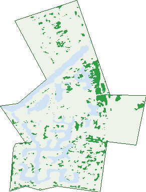
Green: 10 m cells where trees dominate, satellite 2021. Blue: water. The line is the suburb boundary.
| Canopy share, 1 m canopy height map, 2020 | 9.3% |
|---|---|
| Land with trees, 10 m satellite map, 2021 | 5.8% |
Demographics
Unemployment 3.8% · Labour-force participation 65.3%
Population by age in Patterson Lakes
| 0-4 | 382 |
|---|---|
| 5-14 | 856 |
| 15-19 | 453 |
| 20-24 | 378 |
| 25-34 | 703 |
| 35-44 | 908 |
| 45-54 | 1,258 |
| 55-64 | 1,177 |
| 65-74 | 992 |
| 75-84 | 497 |
| 85+ | 188 |
Dwelling types in Patterson Lakes
| House | 1,838 |
|---|---|
| Townhouse | 758 |
| Apartment | 470 |
| Other | 0 |
Households by weekly income in Patterson Lakes
| <$650 | 461 |
|---|---|
| $650-1,499 | 723 |
| $1,500-2,999 | 866 |
| $3,000+ | 844 |
Top ancestries in Patterson Lakes
| English | 2,874 |
|---|---|
| Australian | 2,307 |
| Irish | 846 |
| Other | 828 |
| Scottish | 689 |
| Italian | 456 |
Housing tenure in Patterson Lakes
| Owned | 1,184 |
|---|---|
| Mortgage | 1,256 |
| Rented | 464 |
| Other | 105 |
Cars per household in Patterson Lakes
| 0 | 139 |
|---|---|
| 1 | 932 |
| 2 | 1,297 |
| 3 | 417 |
| 4+ | 238 |
Commute to work in Patterson Lakes
| Car | 2,409 |
|---|---|
| Train | 34 |
| Bus | 8 |
| Tram/ferry | 0 |
| Walked | 37 |
| Bicycle | 20 |
| Home | 1,024 |
Top countries of birth in Patterson Lakes
| England | 380 |
|---|---|
| China | 197 |
| New Zealand | 129 |
| India | 101 |
| South Africa | 67 |
| Scotland | 66 |
Languages used at home in Patterson Lakes
| Mandarin | 220 |
|---|---|
| Greek | 141 |
| Cantonese | 86 |
| Italian | 75 |
| Vietnamese | 73 |
| Spanish | 64 |
Birds & Wildlife Nearby
158,931 bird observations recorded near Patterson Lakes — most often seen:
- Common Starling (9,233)
- Common Myna (8,895)
- Eurasian Blackbird (8,646)
- Little Raven (8,014)
- Pacific Black Duck (6,707)
- Chestnut Teal (6,561)
- Australasian Purple Swamphen (6,159)
- Magpie-lark (5,687)
- Black Swan (5,629)
- Spotted Turtle-dove (5,423)
- White-faced Heron (5,348)
- Eastern Asian Spotted Dove (5,132)
- Southern Magpie-lark (5,103)
Show all 30 birds recorded near Patterson Lakes
- House Sparrow (4,994)
- Welcome Swallow (4,687)
- Southern Victoria Australian Magpie (4,497)
- European Goldfinch (4,424)
- Eurasian Coot (4,421)
- Swamp Harrier (4,366)
- Silver Gull (4,326)
- Australian Magpie (4,292)
- Grey Teal (4,275)
- Red Wattlebird (4,165)
- Little Pied Cormorant (4,161)
- Willie Wagtail (4,094)
- Northern Superb Fairy-wren (4,043)
- Southern Willie Wagtail (3,973)
- Eastern Red Wattlebird (3,952)
- Straw-necked Ibis (3,880)
- Eastern Welcome Swallow (3,844)
Sightings reported by observers, not a survey, so the counts show what people record rather than what lives here. Source: Atlas of Living Australia.
Nearby Suburbs
The closest suburbs to Patterson Lakes:
- Carrum (1.5 km)
- Bonbeach (1.7 km)
- Chelsea (2.9 km)
- Chelsea Heights (3.1 km)
- Edithvale (4.3 km)
- Seaford (4.4 km)
- Carrum Downs (4.7 km)
- Bangholme (5.5 km)
Embed this suburb
Add this free Patterson Lakes stat card to your own site — just copy the code:
Preview:
Cite this page
Quoting these figures? Copy the credit line:
Keep an eye on Patterson Lakes
One email when this data meaningfully changes — new census figures, prices, rankings. No spam, unsubscribe anytime.
Streets
- Acacia Crescent (33)
- Adelong Court (8)
- Admirals Quay (32)
- Alexander Circle (12)
- Alkira Court (25)
- Ariel Way (1)
- Arrunga Court (34)
- Balarang Court (21)
- Beachcomber Court (25)
- Binda Court (13)
- Boloka Court (21)
- Bream Bay (12)
- Brigantine Court (29)
- Canberra Street (90)
- Castaway Court (20)
- Clematis Court (13)
- Clipper Island (20)
- Cocos Court (12)
- Colac Court (34)
- Coral Island Court (21)
- Cossar Place (4)
- Cullen Court (18)
- Curlew Point Drive (59)
- Daniel Close (24)
- Domain Mews (4)
- Erinka Crescent (28)
- Gladesville Boulevard (587)
- Governor Arthur Drive (43)
- Grevillea Court (10)
- Gull Court (11)
- Hannalore Way (16)
- Harbour Drive (108)
- Hatteras Court (21)
- Ibis Court (10)
- Illawong Court (29)
- Iluka Island (12)
- Inner Harbour Drive (69)
- Kalang Court (28)
- Keeling Court (3)
- Kiah Court (19)
- Kulanda Court (11)
- Kurrawa Crescent (66)
- Lady Barlow Court (14)
- Lady Nelson Walk (11)
- Lady Wellington Court (19)
- Lagoon Place (21)
- Lara Place (18)
- Learmonth Road (9)
- Legana Court (47)
- Long Island Point (26)
- Lord Rodney Drive (52)
- Manhattan Court (8)
- Marina Palms (17)
- Marine Drive (14)
- Mariners Island (15)
- Marlin Bay (7)
- Mcleod Road (420)
- Mermaid Court (25)
- Moina Court (5)
- Myola Street (37)
- Myuna Court (9)
- Nanda Court (19)
- Nautilus Court (23)
- Neptune Court (3)
- North Shore Drive (83)
- Oasis Court (21)
- Ocean Lane (6)
- Ocean Reef Drive (42)
- Oceanic Drive (21)
- Old Wells Road (58)
- Palm Beach Drive (188)
- Palm Island Court (29)
- Pier One Drive (45)
- Pitcairn Place (4)
- Plover Court (11)
- Portal Place (14)
- Prince Albert Mews (13)
- Rhode Island (17)
- Riverside West (20)
- Royal Charlotte Drive (7)
- Salmon Bay (7)
- Sandridge Court (26)
- Scarborough Drive (65)
- Schooner Bay Drive (44)
- Scott Court (15)
- Seafarer Court (20)
- Shell Court (22)
- Snapper Point Drive (29)
- Solway Close (11)
- Southseas Place (8)
- Sovereign Close (17)
- Starboard Lane (13)
- Staten Island (12)
- Stephanie Court (20)
- Sun Rise (10)
- Swallow Court (23)
- Tasman Court (12)
- Terrigal Drive (46)
- The Boulevard (50)
- The Parkway (50)
- Thompson Road (165)
- Tiller Lane (13)
- Tingara Court (7)
- Tori Place (12)
- Town Lane (9)
- Tradewinds Lane (10)
- Trinity Court (20)
- Tumut Court (8)
- Webster Drive (17)
- Wells Road (10)
- Wetland Drive (41)
- William Salthouse Way (13)
- Wyong Court (33)
- Yass Court (6)