Moorabbin VIC 3189
6,452 addresses · 127 streets
Isaacs Electorate › Kingston (Vic.) LGA › Moorabbin · 16 km from Melbourne
📦 Thinking of moving here? Read the Moorabbin moving guide

Living Here
Moorabbin is a suburb of Victoria, home to about 6,287 people, with a median age of 39. The typical household earns around $2,031 a week, with median rent near $431 a week. Most homes are houses. About 69% of households own their home and 29% rent. Most workers drive to work. Common community backgrounds include English, Australian, Irish. On the ABS socio-economic scale it sits in decile 9 of 10 nationally — a relatively advantaged area. The median house sells for about $1,286,500.
Over time — Census 2001 → 2021
Dashed line: district figures for the Moorabbin - Heatherton statistical area (SA2), the smallest area the ABS published before 2011. Solid line: Moorabbin itself.
Getting Around & Local Services
19 Catholic churches
- Saint Catherine Laboure Catholic Church
- St Agnes' Catholic Church
- St Peter's Catholic Church
- Immaculate Heart of Mary
- Our Lady of The Assumption Catholic Church
- Our Lady of Perpetual Succour and Saint Andrew's Church
- St. Finbar's East Brighton Parish
- Sacred Heart
- St Patrick's Catholic Church
- Sacred Heart Oakleigh Catholic
1 carpenter
Getting around. Train station: Highett, 1.4 km south-west · Tram stop: Stop 68: Nepean Highway, 4.4 km north-west · Bus interchange: Southland Shopping Centre/Karen Street, 1.9 km south · Airport: Moorabbin Airport, 5.8 km south-east.
Sport & Recreation
3 facilities recorded in Moorabbin.
- GR Bricker Reserve Athletics, Cricket
- Moorabbin Indoor Tennis Netball (Indoor), Soccer (Indoor Soccer / Futsal), Tennis (Indoor)
- St Kilda Football Gorund Australian Rules Football
Socio-economic Standing
Deciles from 1 (lowest) to 10 (highest), against all Australian suburbs. The overall figure weighs advantage and disadvantage together; economic resources counts income and housing, and education & jobs counts qualifications and occupation. They often differ. Source: ABS SEIFA 2021.
Median Sale Prices
Median of recorded sales in the period, not a valuation. Source: Victorian Property Sales Report, Land Use Victoria.
Tree cover
🌳 Tree canopy: 4.9% share of land under canopy · satellite map, 2020
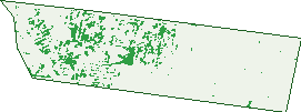
Green: 10 m cells where trees dominate, satellite 2021. Blue: water. The line is the suburb boundary.
| Canopy share, 1 m canopy height map, 2020 | 4.9% |
|---|---|
| Land with trees, 10 m satellite map, 2021 | 8.1% |
Demographics
Unemployment 3.8% · Labour-force participation 65.6%
Population by age in Moorabbin
| 0-4 | 419 |
|---|---|
| 5-14 | 753 |
| 15-19 | 311 |
| 20-24 | 301 |
| 25-34 | 832 |
| 35-44 | 1,061 |
| 45-54 | 876 |
| 55-64 | 695 |
| 65-74 | 530 |
| 75-84 | 358 |
| 85+ | 161 |
Dwelling types in Moorabbin
| House | 1,852 |
|---|---|
| Townhouse | 209 |
| Apartment | 345 |
| Other | 5 |
Households by weekly income in Moorabbin
| <$650 | 379 |
|---|---|
| $650-1,499 | 521 |
| $1,500-2,999 | 689 |
| $3,000+ | 712 |
Top ancestries in Moorabbin
| English | 1,741 |
|---|---|
| Australian | 1,579 |
| Other | 985 |
| Irish | 656 |
| Scottish | 490 |
| Chinese | 407 |
Housing tenure in Moorabbin
| Owned | 716 |
|---|---|
| Mortgage | 927 |
| Rented | 694 |
| Other | 43 |
Cars per household in Moorabbin
| 0 | 175 |
|---|---|
| 1 | 940 |
| 2 | 944 |
| 3 | 242 |
| 4+ | 79 |
Commute to work in Moorabbin
| Car | 1,477 |
|---|---|
| Train | 74 |
| Bus | 26 |
| Tram/ferry | 0 |
| Walked | 63 |
| Bicycle | 16 |
| Home | 1,113 |
Top countries of birth in Moorabbin
| India | 259 |
|---|---|
| China | 216 |
| England | 199 |
| Greece | 113 |
| New Zealand | 93 |
| Philippines | 67 |
Languages used at home in Moorabbin
| Mandarin | 258 |
|---|---|
| Greek | 240 |
| Russian | 177 |
| Italian | 86 |
| Hindi | 83 |
| Gujarati | 77 |
Birds & Wildlife Nearby
182,673 bird observations recorded near Moorabbin — most often seen:
- Little Raven (10,720)
- Common Myna (10,599)
- Noisy Miner (9,240)
- Australian Magpie (8,964)
- Rainbow Lorikeet (8,885)
- Spotted Turtle-dove (8,850)
- Eurasian Blackbird (8,252)
- Common Starling (7,815)
- Red Wattlebird (7,529)
- Magpie-lark (7,346)
- Pacific Black Duck (6,968)
- Silver Gull (6,784)
- Welcome Swallow (6,489)
Show all 30 birds recorded near Moorabbin
- Eurasian Coot (6,414)
- Dusky Moorhen (5,391)
- Australasian Purple Swamphen (5,312)
- Grey Butcherbird (5,189)
- Brown Thornbill (5,150)
- Rock Dove (4,491)
- Crested Pigeon (4,319)
- Little Wattlebird (4,260)
- House Sparrow (4,147)
- Superb Fairy-wren (4,118)
- Chestnut Teal (4,024)
- Australasian Grebe (3,890)
- Little Pied Cormorant (3,637)
- White-plumed Honeyeater (3,499)
- Eastern Rosella (3,498)
- Australian Wood Duck (3,472)
- Grey Teal (3,421)
Sightings reported by observers, not a survey, so the counts show what people record rather than what lives here. Source: Atlas of Living Australia.
Nearby Suburbs
The closest suburbs to Moorabbin:
- Highett (1.6 km)
- Hampton East (2.1 km)
- Bentleigh (2.4 km)
- Bentleigh East (2.4 km)
- Cheltenham (2.6 km)
- Heatherton (3.1 km)
- Mckinnon (3.6 km)
- Sandringham (3.7 km)
Embed this suburb
Add this free Moorabbin stat card to your own site — just copy the code:
Preview:
Cite this page
Quoting these figures? Copy the credit line:
Keep an eye on Moorabbin
One email when this data meaningfully changes — new census figures, prices, rankings. No spam, unsubscribe anytime.
Streets
- Alex Avenue (82)
- Alison Street (28)
- Anson Court (3)
- Ashlar Road (38)
- Avon Street (41)
- Baker Street (46)
- Barbara Street (47)
- Barilla Road (102)
- Bataba Street (8)
- Beilby Street (9)
- Bemm Street (7)
- Bibby Court (21)
- Bignell Road (52)
- Birdum Street (13)
- Biscop Road (30)
- Bruthen Street (35)
- Buchan Street (12)
- Bulli Street (111)
- Capella Crescent (83)
- Central Avenue (163)
- Chapel Road (185)
- Chesterville Road (265)
- Clay Street (103)
- Cochranes Road (220)
- Cooma Street (22)
- Corr Street (25)
- Dactyl Road (41)
- Dane Road (4)
- Deal Close (4)
- Doonga Avenue (4)
- Ebden Street (56)
- Edgecombe Court (32)
- Elna Court (12)
- Ewar Street (4)
- Exley Drive (10)
- Faye Street (15)
- Fiddes Street (68)
- Fletcher Street (65)
- Florida Court (15)
- Franklin Street (69)
- Freighter Road (6)
- Friars Road (37)
- Gavin Street (38)
- Genoa Street (125)
- Grandview Grove (69)
- Gwenda Avenue (63)
- Hamer Street (36)
- Harlow Court (8)
- Healey Street (106)
- Hector Court (24)
- Henley Court (17)
- Herne Close (4)
- Hillston Road (66)
- Horscroft Place (85)
- Horsmunden Road (25)
- Hythe Close (4)
- Independence Street (38)
- Isabella Street (57)
- Ivy Court (6)
- Joan Street (24)
- Joel Court (29)
- Joyner Street (8)
- Keys Road (116)
- Kiama Street (3)
- Kilpa Road (32)
- Kingsway (1)
- Kinwal Court (24)
- Le Page Lane (1)
- Le Page Street (15)
- Lennox Street (18)
- Levanswell Road (257)
- Linton Street (37)
- Margaret Street (35)
- Marrbridge Road (66)
- Matilda Road (76)
- Maxwell Court (20)
- Mayswood Court (6)
- Narooma Street (35)
- Nellbern Road (39)
- Nelson Street (53)
- Nepean Highway (290)
- Nette Court (20)
- Noel Court (11)
- Nowra Street (26)
- Oconnell Street (12)
- Orana Court (7)
- Otford Close (4)
- Perry Street (65)
- Powlett Street (33)
- Railway Station Concourse (8)
- Ranleigh Court (20)
- Redholme Street (27)
- Rhonda Court (8)
- Rica Street (28)
- Rice Street (18)
- Rings Road (20)
- Roberna Street (180)
- Rodney Street (22)
- Romney Close (9)
- Ronald Street (15)
- Roper Street (28)
- Rosebud Avenue (29)
- Rowans Road (114)
- Royena Road (57)
- Schofield Street (37)
- Sheppard Street (53)
- Simpson Street (21)
- South Road (418)
- Station Street (180)
- Stayner Grove (25)
- Sullivan Street (36)
- Tabbita Street (61)
- Taverner Street (13)
- Taylor Street (73)
- Trent Street (22)
- Tuck Street (41)
- Walsh Avenue (25)
- Walter Street (31)
- Warrigal Road (142)
- Welwyn Court (4)
- Wendy Street (2)
- Wickham Road (147)
- William Street (53)
- Wimmera Street (28)
- Winston Court (19)
- Worthing Road (31)
- Wren Road (80)