Hampton East VIC 3188
3,768 addresses · 75 streets
Goldstein Electorate › Bayside (Vic.) LGA › Hampton East · 15 km from Melbourne
📦 Thinking of moving here? Read the Hampton East moving guide

Living Here
Hampton East is a suburb of Victoria, home to about 5,069 people, with a median age of 40. The typical household earns around $1,953 a week, with median rent near $400 a week. Most homes are houses. About 63% of households own their home and 35% rent. Most workers work from home. Common community backgrounds include English, Australian, Irish. On the ABS socio-economic scale it sits in decile 9 of 10 nationally — a relatively advantaged area. The median house sells for about $1,430,000.
Over time — Census 2001 → 2021
Dashed line: district figures for the Hampton statistical area (SA2), the smallest area the ABS published before 2011. Solid line: Hampton East itself.
Getting Around & Local Services
19 Catholic churches
- Immaculate Heart of Mary
- St Agnes' Catholic Church
- Saint Catherine Laboure Catholic Church
- Our Lady of Perpetual Succour and Saint Andrew's Church
- Sacred Heart
- St. Finbar's East Brighton Parish
- St Joan of Arc Catholic Church
- St Peter's Catholic Church
- Our Lady of The Assumption Catholic Church
- St Patrick's Catholic Church
2 playgrounds
1 carpenter
Getting around. Train station: Moorabbin, 700 m north-east · Tram stop: Stop 68: Nepean Highway, 2.9 km north-west · Bus interchange: Southland Shopping Centre/Karen Street, 3 km south-east · Airport: Moorabbin Airport, 7.6 km south-east.
Sport & Recreation
2 facilities recorded in Hampton East.
- Dane Road Reserve Cricket, Tennis (Outdoor)
- Moorabbin West Reserve Baseball, Cricket, Softball
Socio-economic Standing
Deciles from 1 (lowest) to 10 (highest), against all Australian suburbs. The overall figure weighs advantage and disadvantage together; economic resources counts income and housing, and education & jobs counts qualifications and occupation. They often differ. Source: ABS SEIFA 2021.
Median Sale Prices
Median of recorded sales in the period, not a valuation. Source: Victorian Property Sales Report, Land Use Victoria.
Tree cover
🌳 Tree canopy: 16.5% share of land under canopy · satellite map, 2020
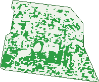
Green: 10 m cells where trees dominate, satellite 2021. Blue: water. The line is the suburb boundary.
| Canopy share, 1 m canopy height map, 2020 | 16.5% |
|---|---|
| Land with trees, 10 m satellite map, 2021 | 31.8% |
Demographics
Unemployment 4.5% · Labour-force participation 64.2%
Population by age in Hampton East
| 0-4 | 318 |
|---|---|
| 5-14 | 604 |
| 15-19 | 269 |
| 20-24 | 281 |
| 25-34 | 599 |
| 35-44 | 811 |
| 45-54 | 774 |
| 55-64 | 632 |
| 65-74 | 397 |
| 75-84 | 263 |
| 85+ | 119 |
Dwelling types in Hampton East
| House | 1,168 |
|---|---|
| Townhouse | 453 |
| Apartment | 424 |
| Other | 0 |
Households by weekly income in Hampton East
| <$650 | 398 |
|---|---|
| $650-1,499 | 394 |
| $1,500-2,999 | 471 |
| $3,000+ | 651 |
Top ancestries in Hampton East
| English | 1,653 |
|---|---|
| Australian | 1,429 |
| Other | 759 |
| Irish | 544 |
| Scottish | 475 |
| Chinese | 293 |
Housing tenure in Hampton East
| Owned | 570 |
|---|---|
| Mortgage | 701 |
| Rented | 710 |
| Other | 38 |
Cars per household in Hampton East
| 0 | 198 |
|---|---|
| 1 | 853 |
| 2 | 723 |
| 3 | 175 |
| 4+ | 74 |
Commute to work in Hampton East
| Car | 1,006 |
|---|---|
| Train | 50 |
| Bus | 14 |
| Tram/ferry | 0 |
| Walked | 33 |
| Bicycle | 14 |
| Home | 1,030 |
Top countries of birth in Hampton East
| England | 253 |
|---|---|
| China | 124 |
| India | 97 |
| New Zealand | 89 |
| Greece | 58 |
| South Africa | 48 |
Languages used at home in Hampton East
| Mandarin | 160 |
|---|---|
| Greek | 156 |
| Russian | 126 |
| Spanish | 79 |
| Italian | 51 |
| Polish | 50 |
Birds & Wildlife Nearby
120,363 bird observations recorded near Hampton East — most often seen:
- Little Raven (6,879)
- Noisy Miner (6,593)
- Common Myna (6,462)
- Rainbow Lorikeet (6,345)
- Australian Magpie (6,326)
- Spotted Turtle-dove (5,256)
- Red Wattlebird (4,904)
- Magpie-lark (4,858)
- Common Starling (4,853)
- Eurasian Blackbird (4,733)
- Silver Gull (4,553)
- Welcome Swallow (4,517)
- Pacific Black Duck (4,282)
Show all 30 birds recorded near Hampton East
- Grey Butcherbird (3,825)
- Eurasian Coot (3,770)
- Rock Dove (3,702)
- Australasian Purple Swamphen (3,361)
- Dusky Moorhen (3,353)
- Brown Thornbill (3,216)
- Crested Pigeon (2,977)
- Little Wattlebird (2,925)
- Chestnut Teal (2,839)
- Superb Fairy-wren (2,810)
- House Sparrow (2,650)
- Little Pied Cormorant (2,571)
- Grey Teal (2,433)
- Black Swan (2,423)
- White-plumed Honeyeater (2,365)
- Eastern Rosella (2,337)
- Hoary-headed Grebe (2,245)
Sightings reported by observers, not a survey, so the counts show what people record rather than what lives here. Source: Atlas of Living Australia.
Nearby Suburbs
The closest suburbs to Hampton East:
- Highett (1.7 km)
- Hampton (1.9 km)
- Bentleigh (1.9 km)
- Sandringham (2.1 km)
- Moorabbin (2.1 km)
- Brighton East (2.7 km)
- Mckinnon (3.1 km)
- Bentleigh East (3.6 km)
Embed this suburb
Add this free Hampton East stat card to your own site — just copy the code:
Preview:
Cite this page
Quoting these figures? Copy the credit line:
Keep an eye on Hampton East
One email when this data meaningfully changes — new census figures, prices, rankings. No spam, unsubscribe anytime.
Streets
- Acheron Court (23)
- Apex Avenue (87)
- Bartlett Street (52)
- Berend Street (4)
- Besant Street (69)
- Bluff Road (316)
- Burt Crescent (34)
- Carrington Street (43)
- Charming Street (89)
- Clyde Street (1)
- Cooke Avenue (50)
- Crest Avenue (16)
- Daff Avenue (50)
- Dane Road (38)
- Danson Street (1)
- Dudley Avenue (34)
- Eldon Court (21)
- Evans Avenue (40)
- Exley Road (31)
- Flowerdale Road (60)
- Gary Avenue (6)
- Guernsey Avenue (18)
- Harry Street (11)
- Heath Crescent (56)
- Henrietta Street (24)
- Herbert Street (1)
- Highbury Avenue (51)
- Howitt Avenue (11)
- June Street (2)
- Katoomba Street (81)
- Keiller Street (55)
- Keith Street (98)
- Kelly Avenue (87)
- Kelsall Court (17)
- King Street (199)
- Kinross Street (105)
- Leith Crescent (90)
- Leonard Street (50)
- Little Avenue (7)
- Lonsdale Avenue (112)
- Molong Avenue (2)
- Monamie Avenue (1)
- Muir Street (1)
- Nepean Avenue (105)
- Nepean Highway (92)
- Oconnor Crescent (25)
- Oswald Thomas Avenue (45)
- Oval Lane (1)
- Overend Close (24)
- Parkview Crescent (30)
- Randell Crescent (6)
- Reynolds Street (87)
- Ridge Avenue (30)
- Roydon Street (119)
- Saltair Street (20)
- Scarborough Drive (29)
- Scott Street (17)
- Seafoam Street (25)
- Seaton Road (1)
- Short Street (40)
- South Road (175)
- Spring Road (86)
- Stonehaven Crescent (33)
- Summit Avenue (28)
- Sunlit Court (21)
- Sybil Street (21)
- Tarwin Avenue (27)
- Telford Street (1)
- Terrens Close (46)
- Tweed Street (1)
- Warland Road (49)
- Wickham Road (309)
- Widdop Crescent (101)
- Wishart Street (29)
- Worthing Road (1)