Maddingley VIC 3340
3,583 addresses · 177 streets
Hawke Electorate › Moorabool LGA › Maddingley · 50 km from Melbourne
📦 Thinking of moving here? Read the Maddingley moving guide

Living Here
Maddingley is a suburb of Victoria, home to about 5,491 people, with a median age of 33. The typical household earns around $1,923 a week, with median rent near $366 a week. Most homes are houses. About 75% of households own their home and 24% rent. Most workers drive to work. Common community backgrounds include Australian, English, Scottish. On the ABS socio-economic scale it sits in decile 6 of 10 nationally — a mid-range area. The median house sells for about $620,000.
Over time — Census 2001 → 2021
Dashed line: district figures for the Bacchus Marsh statistical area (SA2), the smallest area the ABS published before 2011. Solid line: Maddingley itself.
Getting Around & Local Services
2 Catholic churches
1 pharmacy
1 dentist
1 vet
1 childcare centre
1 library
3 gyms & sports centres
2 golf clubs
1 butcher
1 hardware store
2 hairdressers
1 mechanic
1 carpenter
2 places to stay
Getting around. Train station: Bacchus Marsh, 1.7 km east · Airport: Melbourne Airport, 36.3 km east.
Sport & Recreation
4 facilities recorded in Maddingley.
- Bacchus Marsh Club Grounds Equestrian
- Bacchus Marsh Leisure Centre Badminton, Basketball, Fitness / Gymnasium Workouts, Netball (Indoor), Soccer (Indoor Soccer / Futsal)
- Bacchus Marsh West Golf Club Golf
- Maddingley Park Australian Rules Football, Cricket, Netball, Tennis (Outdoor)
Socio-economic Standing
Deciles from 1 (lowest) to 10 (highest), against all Australian suburbs. The overall figure weighs advantage and disadvantage together; economic resources counts income and housing, and education & jobs counts qualifications and occupation. They often differ. Source: ABS SEIFA 2021.
Median Sale Prices
Median of recorded sales in the period, not a valuation. Source: Victorian Property Sales Report, Land Use Victoria.
Tree cover
🌳 Tree canopy: 3.9% share of land under canopy · satellite map, 2020
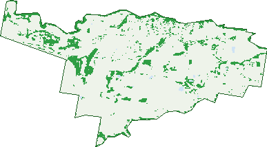
Green: 10 m cells where trees dominate, satellite 2021. Blue: water. The line is the suburb boundary.
| Canopy share, 1 m canopy height map, 2020 | 3.9% |
|---|---|
| Land with trees, 10 m satellite map, 2021 | 13.1% |
Demographics
Unemployment 3.8% · Labour-force participation 68.3%
Population by age in Maddingley
| 0-4 | 477 |
|---|---|
| 5-14 | 812 |
| 15-19 | 268 |
| 20-24 | 310 |
| 25-34 | 996 |
| 35-44 | 886 |
| 45-54 | 605 |
| 55-64 | 422 |
| 65-74 | 418 |
| 75-84 | 209 |
| 85+ | 100 |
Dwelling types in Maddingley
| House | 1,761 |
|---|---|
| Townhouse | 149 |
| Apartment | 3 |
| Other | 8 |
Households by weekly income in Maddingley
| <$650 | 249 |
|---|---|
| $650-1,499 | 459 |
| $1,500-2,999 | 720 |
| $3,000+ | 398 |
Top ancestries in Maddingley
| Australian | 2,046 |
|---|---|
| English | 1,967 |
| Other | 695 |
| Scottish | 542 |
| Irish | 540 |
| Indian | 263 |
Housing tenure in Maddingley
| Owned | 361 |
|---|---|
| Mortgage | 1,053 |
| Rented | 458 |
| Other | 25 |
Cars per household in Maddingley
| 0 | 67 |
|---|---|
| 1 | 616 |
| 2 | 806 |
| 3 | 276 |
| 4+ | 138 |
Commute to work in Maddingley
| Car | 1,718 |
|---|---|
| Train | 54 |
| Bus | 7 |
| Tram/ferry | 0 |
| Walked | 40 |
| Bicycle | 8 |
| Home | 521 |
Top countries of birth in Maddingley
| India | 333 |
|---|---|
| England | 142 |
| New Zealand | 79 |
| Philippines | 53 |
| Scotland | 34 |
| Sri Lanka | 31 |
Languages used at home in Maddingley
| Punjabi | 311 |
|---|---|
| Hindi | 62 |
| Spanish | 41 |
| Samoan | 25 |
| Italian | 23 |
| Urdu | 22 |
Birds & Wildlife Nearby
21,429 bird observations recorded near Maddingley — most often seen:
- Common Starling (1,250)
- Eurasian Blackbird (1,242)
- Little Raven (1,143)
- Common Myna (1,100)
- House Sparrow (954)
- Australian Magpie (883)
- Red Wattlebird (812)
- Superb Fairy-wren (805)
- New Holland Honeyeater (802)
- White-plumed Honeyeater (758)
- Sulphur-crested Cockatoo (727)
- Magpie-lark (723)
- Willie Wagtail (674)
Show all 30 birds recorded near Maddingley
- Red-rumped Parrot (648)
- Galah (626)
- European Goldfinch (617)
- Southern Victoria Australian Magpie (608)
- Spotted Turtle-dove (604)
- Welcome Swallow (589)
- Crimson Rosella (588)
- Long-billed Corella (579)
- Crested Pigeon (572)
- Pacific Black Duck (541)
- Rainbow Lorikeet (532)
- Eastern White-plumed Honeyeater (518)
- Eastern New Holland Honeyeater (516)
- Eastern Red Wattlebird (516)
- Silvereye (516)
- Australian Wood Duck (510)
- Southern Magpie-lark (476)
Sightings reported by observers, not a survey, so the counts show what people record rather than what lives here. Source: Atlas of Living Australia.
Nearby Suburbs
The closest suburbs to Maddingley:
- Bacchus Marsh (2 km)
- Darley (4 km)
- Rowsley (5.3 km)
- Pentland Hills (5.4 km)
- Merrimu (5.9 km)
- Parwan (6 km)
- Hopetoun Park (7.6 km)
- Long Forest (9 km)
Embed this suburb
Add this free Maddingley stat card to your own site — just copy the code:
Preview:
Cite this page
Quoting these figures? Copy the credit line:
Keep an eye on Maddingley
One email when this data meaningfully changes — new census figures, prices, rankings. No spam, unsubscribe anytime.
Streets
- Adams Way (6)
- Albys Lane (1)
- Armstrong Rise (31)
- Bacchus Marsh-balliang Road (22)
- Bacchus Street (9)
- Barrett Road (16)
- Barry Street (34)
- Blake Drive (10)
- Blossom Drive (48)
- Bond Street (6)
- Booth Road (28)
- Boyes Close (7)
- Brighton Rise (34)
- Browns Lane (1)
- Bulbine Road (10)
- Calderwood Road (54)
- Candlebark Crescent (20)
- Cardell Street (13)
- Caspar Place (20)
- Cassinia Boulevard (7)
- Chippendall Street (26)
- Clementine Street (9)
- Coates Lane (8)
- Cobham Rise (14)
- Cook Avenue (6)
- Cosgrove Drive (66)
- Croton Lane (14)
- Crowe Street (14)
- Cummings Road (2)
- Darcy Street (51)
- Davison Court (20)
- Delahey Close (14)
- Dewar Crescent (27)
- Dixon Way (15)
- Dogherty Court (17)
- Doolan Street (10)
- Drever Place (28)
- Dubout Street (15)
- Durward Avenue (29)
- Duval Drive (27)
- Dyer Way (16)
- East Maddingley Road (7)
- Edgerton Place (18)
- Eighth Mews (4)
- Ember Road (3)
- Essence Boulevard (18)
- Ethan Street (10)
- Fairbank Way (22)
- Farrow Place (12)
- Fifth Mews (6)
- Fincher Drive (2)
- Finn Court (9)
- First Mews (6)
- Fisken Street (21)
- Fourth Mews (5)
- Franklin Street (25)
- Gaynor Street (47)
- Geelong-bacchus Marsh Road (4)
- Gibson Way (15)
- Gladman Road (38)
- Glasheen Drive (30)
- Gleeson Court (17)
- Glenn Road (14)
- Godfrey Ridge (8)
- Grant Street (23)
- Grebe Terrace (1)
- Griffith Street (121)
- Guy Place (4)
- Hakea Close (10)
- Harkness Road (39)
- Harry Vallence Drive (34)
- Hawkins Way (4)
- Hegarty Place (11)
- Hillside Street (19)
- Hollyhoke Drive (45)
- Ibis Way (9)
- Inglis Street (53)
- Keddell Place (5)
- Kennedy Place (15)
- Kerrs Road (1)
- Kingfisher Way (14)
- Knight Street (13)
- Labilliere Street (68)
- Ladhams Way (33)
- Leahy Street (19)
- Lightwood Court (7)
- Lodge Street (8)
- Lomandra Avenue (18)
- Love Close (4)
- Maris Circuit (25)
- Mccormacks Road (73)
- Mccrae Street (44)
- Mclennan Avenue (27)
- Mcpherson Street (27)
- Meikle Street (21)
- Michelson Drive (28)
- Mimulus Road (27)
- Mitchem Street (4)
- Moffatt Street (23)
- Moon Court (10)
- Moonglow Crescent (29)
- Moore Street (46)
- Morgan Street (29)
- Murcott Road (10)
- Murdoch Court (11)
- Murphys Lane (22)
- Ninth Mews (4)
- Nixon Court (7)
- Oleary Way (57)
- Oliver Way (16)
- Orchard Street (23)
- Orton Crescent (15)
- Osage Street (9)
- Osborne Street (32)
- Oswin Street (16)
- Park Street (33)
- Parkside Avenue (19)
- Parwan Road (44)
- Parwan-exford Road (1)
- Peelmans Lane (28)
- Peters Close (20)
- Pezet Circuit (28)
- Phillips Road (10)
- Platt Drive (40)
- Porter Avenue (49)
- Powlett Street (44)
- Pratia Close (9)
- Providence Drive (1)
- Quamby Mews (6)
- Quinn Street (7)
- Rawlinson Street (41)
- Reddrop Street (3)
- Rembrandt Drive (27)
- Richardson Court (12)
- River Drive (5)
- Rivergum Place (12)
- Ronald Street (44)
- Rowsley Station Road (7)
- Rowsley Station Road W (1)
- Rudhall Street (18)
- Rutherford Court (32)
- Ryder Close (9)
- School Lane (2)
- Second Mews (6)
- Seventh Mews (4)
- Sixth Mews (6)
- Skene Way (4)
- Slack Mews (9)
- Slattery Court (16)
- Smith Street (26)
- Sonny Close (13)
- South Maddingley Road (21)
- Station Street (42)
- Stonehill Drive (215)
- Swanton Avenue (14)
- Sweet Avenue (25)
- Taverner Street (31)
- Tenth Mews (4)
- Tess Court (9)
- Tesselaar Avenue (7)
- Third Mews (4)
- Tilley Drive (38)
- Tilleys Road (1)
- Tinker Lane (9)
- Tregoning Street (8)
- Triandra Court (5)
- Usher Way (6)
- Vallence Road (13)
- Vallence Road N (4)
- Vanessa Close (16)
- Werribee Vale Road (25)
- Wimpara Crescent (18)
- Witham Road (17)
- Woodswallow Street (10)
- Woolpack Road (7)
- Xavier Road (36)
- Yellow Gum Way (3)