Bacchus Marsh VIC 3340
5,113 addresses · 183 streets
Hawke Electorate › Moorabool LGA › Bacchus Marsh · 49 km from Melbourne
📦 Thinking of moving here? Read the Bacchus Marsh moving guide

Living Here
Bacchus Marsh is a suburb of Victoria, home to about 7,808 people, with a median age of 39. The typical household earns around $1,508 a week, with median rent near $330 a week. Most homes are houses. About 71% of households own their home and 26% rent. Most workers drive to work. Common community backgrounds include English, Australian, Irish. On the ABS socio-economic scale it sits in decile 4 of 10 nationally — a mid-range area. The median house sells for about $610,000.
Over time — Census 2001 → 2021
Dashed line: district figures for the Bacchus Marsh statistical area (SA2), the smallest area the ABS published before 2011. Solid line: Bacchus Marsh itself.
Getting Around & Local Services
2 Catholic churches
1 pharmacy
1 dentist
1 vet
2 childcare & kindergartens
1 library
3 gyms & sports centres
2 golf clubs
1 butcher
1 hardware store
2 hairdressers
1 mechanic
1 carpenter
2 places to stay
Getting around. Train station: Bacchus Marsh, 1.8 km south · Airport: Melbourne Airport, 35.2 km east.
Sport & Recreation
4 facilities recorded in Bacchus Marsh.
- Avenue Bowling club Lawn Bowls
- Bacchus Marsh Aquatic Centre Swimming
- Bacchus Marsh Bowling club Lawn Bowls
- Mason's Lane Reserve Athletics, Baseball, Cricket, Soccer
Socio-economic Standing
Deciles from 1 (lowest) to 10 (highest), against all Australian suburbs. The overall figure weighs advantage and disadvantage together; economic resources counts income and housing, and education & jobs counts qualifications and occupation. They often differ. Source: ABS SEIFA 2021.
Median Sale Prices
Median of recorded sales in the period, not a valuation. Source: Victorian Property Sales Report, Land Use Victoria.
Tree cover
🌳 Tree canopy: 7.6% share of land under canopy · satellite map, 2020
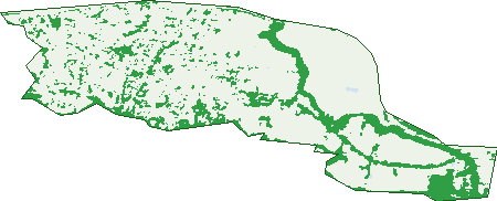
Green: 10 m cells where trees dominate, satellite 2021. Blue: water. The line is the suburb boundary.
| Canopy share, 1 m canopy height map, 2020 | 7.6% |
|---|---|
| Land with trees, 10 m satellite map, 2021 | 20.8% |
Demographics
Unemployment 4.4% · Labour-force participation 57.6%
Population by age in Bacchus Marsh
| 0-4 | 497 |
|---|---|
| 5-14 | 965 |
| 15-19 | 366 |
| 20-24 | 395 |
| 25-34 | 1,192 |
| 35-44 | 962 |
| 45-54 | 881 |
| 55-64 | 832 |
| 65-74 | 940 |
| 75-84 | 593 |
| 85+ | 181 |
Dwelling types in Bacchus Marsh
| House | 2,657 |
|---|---|
| Townhouse | 394 |
| Apartment | 64 |
| Other | 31 |
Households by weekly income in Bacchus Marsh
| <$650 | 598 |
|---|---|
| $650-1,499 | 873 |
| $1,500-2,999 | 949 |
| $3,000+ | 528 |
Top ancestries in Bacchus Marsh
| English | 3,064 |
|---|---|
| Australian | 2,897 |
| Irish | 1,093 |
| Scottish | 952 |
| Other | 660 |
| Ancestry NS | 411 |
Housing tenure in Bacchus Marsh
| Owned | 1,017 |
|---|---|
| Mortgage | 1,181 |
| Rented | 815 |
| Other | 102 |
Cars per household in Bacchus Marsh
| 0 | 194 |
|---|---|
| 1 | 1,217 |
| 2 | 1,133 |
| 3 | 369 |
| 4+ | 200 |
Commute to work in Bacchus Marsh
| Car | 2,151 |
|---|---|
| Train | 58 |
| Bus | 5 |
| Tram/ferry | 0 |
| Walked | 92 |
| Bicycle | 3 |
| Home | 707 |
Top countries of birth in Bacchus Marsh
| England | 255 |
|---|---|
| India | 204 |
| New Zealand | 116 |
| Scotland | 63 |
| Germany | 45 |
| Malta | 39 |
Languages used at home in Bacchus Marsh
| Punjabi | 176 |
|---|---|
| Italian | 40 |
| Hindi | 34 |
| Greek | 26 |
| Urdu | 23 |
| Spanish | 22 |
Birds & Wildlife Nearby
23,216 bird observations recorded near Bacchus Marsh — most often seen:
- Eurasian Blackbird (1,360)
- Common Starling (1,316)
- Little Raven (1,240)
- Common Myna (1,173)
- House Sparrow (1,023)
- Australian Magpie (982)
- Red Wattlebird (903)
- Superb Fairy-wren (888)
- New Holland Honeyeater (876)
- Sulphur-crested Cockatoo (814)
- Magpie-lark (812)
- White-plumed Honeyeater (808)
- Willie Wagtail (725)
Show all 30 birds recorded near Bacchus Marsh
- European Goldfinch (688)
- Crimson Rosella (680)
- Galah (680)
- Red-rumped Parrot (672)
- Spotted Turtle-dove (662)
- Welcome Swallow (660)
- Southern Victoria Australian Magpie (645)
- Crested Pigeon (616)
- Long-billed Corella (604)
- Silvereye (589)
- Pacific Black Duck (586)
- Rainbow Lorikeet (563)
- Australian Wood Duck (544)
- Eastern Red Wattlebird (540)
- Eastern New Holland Honeyeater (530)
- Grey Shrike-thrush (519)
- Eastern White-plumed Honeyeater (518)
Sightings reported by observers, not a survey, so the counts show what people record rather than what lives here. Source: Atlas of Living Australia.
Nearby Suburbs
The closest suburbs to Bacchus Marsh:
- Maddingley (2 km)
- Darley (2.1 km)
- Merrimu (4.2 km)
- Pentland Hills (5.3 km)
- Parwan (6.9 km)
- Hopetoun Park (7.1 km)
- Rowsley (7.2 km)
- Long Forest (7.4 km)
Embed this suburb
Add this free Bacchus Marsh stat card to your own site — just copy the code:
Preview:
Cite this page
Quoting these figures? Copy the credit line:
Keep an eye on Bacchus Marsh
One email when this data meaningfully changes — new census figures, prices, rankings. No spam, unsubscribe anytime.
Streets
- Adelong Way (68)
- Albion Lane (2)
- Alice Close (17)
- Amaroo Circuit (18)
- Anderson Street (26)
- Angaston Circuit (15)
- Aqualink Boulevard (19)
- Aqualink Circuit (4)
- Aranar Court (11)
- Arnold Road (13)
- Ascot Avenue (10)
- Ashton Street (20)
- Atley Street (15)
- Auburn Crescent (36)
- Bacchus Marsh Road (43)
- Baillie Court (13)
- Balgowan Crescent (11)
- Barbara Court (6)
- Barwon Drive (16)
- Bennett Street (10)
- Bernborough Court (5)
- Berri Street (14)
- Binap Street (8)
- Bird Avenue (3)
- Boronia Parade (9)
- Boyd Street (11)
- Bruce Court (7)
- Bunjil Drive (9)
- Burbidge Drive (88)
- Butler Court (15)
- Candeloro Street (9)
- Canterbury Drive (18)
- Carey Crescent (47)
- Carinya Street (13)
- Casey Court (6)
- Cashmore Court (8)
- Charltonian Close (5)
- Chicory Drive (9)
- Chicquita Court (10)
- Church Street (9)
- Clarinda Street (35)
- Clifton Drive (116)
- Closter Court (19)
- Coghlan Drive (6)
- College Square (56)
- Connor Street (90)
- Costello Close (17)
- Crisp Court (5)
- Crook Street (35)
- Cuddle Court (5)
- Cuthbertson Court (9)
- Dickie Street (19)
- Dickson Street (51)
- Donald Street (13)
- Dowling Drive (3)
- Dugdale Street (26)
- Earl Street (15)
- Ellerslie Court (11)
- Emmett Street (16)
- Epsom Close (12)
- Farm Court (9)
- Finnin Street (5)
- Fisken Street (22)
- Forest Court (17)
- Fulham Circuit (42)
- Garrong Street (18)
- Gell Street (32)
- George Street (51)
- Gisborne Road (146)
- Gothic Drive (3)
- Graham Street (93)
- Grant Street (121)
- Gulline Close (14)
- Gunsynd Court (14)
- Haletts Way (1)
- Halletts Way (90)
- Hamilton Court (11)
- Hartley Court (16)
- Higgins Court (35)
- Hollis Crescent (9)
- Holman Crescent (36)
- Horseshoe Circuit (22)
- Illawong Avenue (6)
- James Court (5)
- Jeffreys Court (6)
- Joan Court (6)
- Kardinia Street (6)
- Kerr Street (7)
- Killara Circuit (40)
- King Street (14)
- Kyeamba Circuit (36)
- Kyle Way (16)
- Ladds Court (11)
- Leila Court (22)
- Lerderderg Street (79)
- Leslie Court (8)
- Lidgett Street (89)
- Lima Street (2)
- Linda Drive (7)
- Lindsay Place (15)
- Lismore Circuit (22)
- Little Court (11)
- Lone Pine Square (46)
- Lord Street (55)
- Lorna Street (30)
- Lorraine Place (11)
- Lyle Street (48)
- Madden Drive (21)
- Mahers Street (15)
- Mahoney Court (12)
- Main Street (491)
- Maisie Court (19)
- Malcolm Street (38)
- Manly Court (7)
- Manor Street (44)
- Margaret Drive (28)
- Martin Court (7)
- Masons Lane (78)
- Mcbride Street (6)
- Mccullagh Street (46)
- Mcdonald Court (10)
- Mcfarland Street (42)
- Mcgrath Street (15)
- Mcgregor Court (11)
- Mclachlan Street (67)
- Mcnicholl Court (8)
- Miles Court (8)
- Millbank Street (27)
- Moe Lane (2)
- Morton Street (10)
- Muir Street (11)
- Munro Court (14)
- Oberon Street (6)
- Ohagan Place (25)
- Okeefe Crescent (31)
- Orchard Street (8)
- Patterson Street (18)
- Pearce Street (1)
- Peter Pan Place (18)
- Pike Place (15)
- Pilmer Street (47)
- Pinnacle Court (26)
- Pinnacle Point Road (11)
- Queens Crescent (24)
- Randwick Avenue (11)
- Rosehill Drive (53)
- Ryan Court (30)
- Sandown Street (10)
- Shea Street (72)
- Shelly Court (13)
- Sheoak Mews (5)
- Sherry Place (8)
- Shields Court (14)
- Simmons Drive (31)
- Simone Road (12)
- Simpson Street (92)
- Stamford Close (11)
- Standfield Street (45)
- Staughton Court (5)
- Steele Court (19)
- Sublime Point Road (24)
- Sugargum Circuit (28)
- Sutherland Street (8)
- Sydney Street (10)
- Todman Close (10)
- Trask Rise (19)
- Tudball Court (11)
- Tulloch Court (12)
- Turner Street (20)
- Underbank Boulevard (395)
- Verdant Crescent (17)
- Waddell Street (23)
- Walton Court (4)
- Warin Lane (19)
- Warrup Crescent (12)
- Watson Street (14)
- Watt Court (3)
- White Avenue (20)
- William Street (17)
- Wilson Place (22)
- Woolpack Road (3)
- Young Street (75)
- Younger Street (9)