Kensington VIC 3031
8,607 addresses · 165 streets
Maribyrnong Electorate › Melbourne LGA › Kensington · 4 km from Melbourne
📦 Thinking of moving here? Read the Kensington moving guide

Living Here
An inner-north-western Melbourne suburb close to the city with a village feel and new apartments, Kensington is young and well-connected. Households average 2.1 people and the median age is 35. Median household income is $2,216 a week, with rent around $416.
Kensington is a suburb of Victoria, home to about 10,745 people, with a median age of 35. The typical household earns around $2,216 a week, with median rent near $416 a week. Most homes are townhouses. About 49% of households own their home and 50% rent. Most workers work from home. Common community backgrounds include English, Australian, Irish. On the ABS socio-economic scale it sits in decile 10 of 10 nationally — a relatively advantaged area. The median house sells for about $1,097,000.
Over time — Census 2001 → 2021
Dashed line: district figures for the Kensington statistical area (SA2), the smallest area the ABS published before 2011. Solid line: Kensington itself.
Getting Around & Local Services
18 childcare & kindergartens
Getting around. Train station: Kensington, 300 m east · Tram stop: Stop 26: Newmarket Station, 650 m north · Bus interchange: Southern Cross Coach Terminal, 3.3 km south-east · Ferry wharf: Port Phillip Ferries Docklands Terminal, 3 km south-east · Airport: Essendon Fields Airport, 8 km north.
Sport & Recreation
4 facilities recorded in Kensington.
- JJ Holland Park Australian Rules Football, BMX, Cricket, Skating, Soccer, Touch Football
- Kensington Banks Tennis Club Tennis (Outdoor)
- Kensington Community Recreation Centre Basketball, Netball (Indoor), Soccer (Indoor Soccer / Futsal), Swimming, Volleyball
- Newmarket Reserve Cricket, Lawn Bowls, Soccer
Socio-economic Standing
Deciles from 1 (lowest) to 10 (highest), against all Australian suburbs. The overall figure weighs advantage and disadvantage together; economic resources counts income and housing, and education & jobs counts qualifications and occupation. They often differ. Source: ABS SEIFA 2021.
Median Sale Prices
Median of recorded sales in the period, not a valuation. Source: Victorian Property Sales Report, Land Use Victoria.
Tree cover
🌳 Tree canopy: 7% share of land under canopy · satellite map, 2020
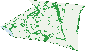
Green: 10 m cells where trees dominate, satellite 2021. Blue: water. The line is the suburb boundary.
| Canopy share, 1 m canopy height map, 2020 | 7.0% |
|---|---|
| Land with trees, 10 m satellite map, 2021 | 12.6% |
Demographics
Unemployment 4.3% · Labour-force participation 74.7%
Population by age in Kensington
| 0-4 | 630 |
|---|---|
| 5-14 | 932 |
| 15-19 | 363 |
| 20-24 | 757 |
| 25-34 | 2,550 |
| 35-44 | 2,138 |
| 45-54 | 1,334 |
| 55-64 | 959 |
| 65-74 | 666 |
| 75-84 | 296 |
| 85+ | 134 |
Dwelling types in Kensington
| House | 810 |
|---|---|
| Townhouse | 2,522 |
| Apartment | 1,384 |
| Other | 6 |
Households by weekly income in Kensington
| <$650 | 650 |
|---|---|
| $650-1,499 | 827 |
| $1,500-2,999 | 1,428 |
| $3,000+ | 1,630 |
Top ancestries in Kensington
| English | 3,257 |
|---|---|
| Australian | 2,772 |
| Other | 1,760 |
| Irish | 1,637 |
| Scottish | 1,157 |
| Chinese | 1,128 |
Housing tenure in Kensington
| Owned | 854 |
|---|---|
| Mortgage | 1,446 |
| Rented | 2,323 |
| Other | 56 |
Cars per household in Kensington
| 0 | 791 |
|---|---|
| 1 | 2,549 |
| 2 | 1,111 |
| 3 | 176 |
| 4+ | 46 |
Commute to work in Kensington
| Car | 1,592 |
|---|---|
| Train | 322 |
| Bus | 56 |
| Tram/ferry | 42 |
| Walked | 207 |
| Bicycle | 256 |
| Home | 3,051 |
Top countries of birth in Kensington
| England | 348 |
|---|---|
| Vietnam | 321 |
| China | 296 |
| New Zealand | 273 |
| India | 171 |
| Malaysia | 143 |
Languages used at home in Kensington
| Mandarin | 353 |
|---|---|
| Cantonese | 342 |
| Vietnamese | 326 |
| Spanish | 171 |
| Italian | 129 |
| Arabic | 109 |
Birds & Wildlife Nearby
433,937 bird observations recorded near Kensington — most often seen:
- Common Myna (25,176)
- Rock Dove (22,869)
- Silver Gull (22,345)
- Rainbow Lorikeet (21,360)
- Magpie-lark (20,568)
- Little Raven (18,840)
- Red Wattlebird (18,594)
- Noisy Miner (17,087)
- House Sparrow (16,597)
- Spotted Turtle-dove (16,346)
- Dusky Moorhen (15,690)
- Pacific Black Duck (15,675)
- Common Starling (15,545)
Show all 30 birds recorded near Kensington
- Eurasian Blackbird (14,637)
- Australian Magpie (14,416)
- Welcome Swallow (14,077)
- Chestnut Teal (13,775)
- Eurasian Coot (13,722)
- White-plumed Honeyeater (13,011)
- Superb Fairy-wren (12,145)
- Australasian Purple Swamphen (11,426)
- Crested Pigeon (10,815)
- Willie Wagtail (10,643)
- New Holland Honeyeater (10,495)
- Australian White Ibis (10,125)
- Australasian Grebe (9,020)
- Little Pied Cormorant (7,748)
- Grey Teal (7,557)
- Pied Currawong (6,853)
- Grey Butcherbird (6,780)
Sightings reported by observers, not a survey, so the counts show what people record rather than what lives here. Source: Atlas of Living Australia.
Nearby Suburbs
The closest suburbs to Kensington:
- Flemington (0.9 km)
- Travancore (1.5 km)
- North Melbourne (1.9 km)
- Ascot Vale (2.1 km)
- Parkville (2.2 km)
- West Melbourne (2.5 km)
- Footscray (2.7 km)
- Docklands (3.2 km)
Embed this suburb
Add this free Kensington stat card to your own site — just copy the code:
Preview:
Cite this page
Quoting these figures? Copy the credit line:
Keep an eye on Kensington
One email when this data meaningfully changes — new census figures, prices, rankings. No spam, unsubscribe anytime.
Streets
- Albermarle Street (107)
- Altona Street (354)
- Anderson Walk (12)
- Anthony Street (1)
- Arden Street (46)
- Bakehouse Road (47)
- Bangalore Street (60)
- Barnett Street (156)
- Barrett Street (22)
- Bateman Road (53)
- Baulderstone Walk (12)
- Bayswater Road (191)
- Bellair Street (136)
- Belmont Road (6)
- Bendall Street (78)
- Bent Street (68)
- Birch Lane (12)
- Bluestone Street (11)
- Bradfield Lane (17)
- Bridges Lane (1)
- Brock Way (2)
- Bruce Street (63)
- Cairncross Lane (3)
- Cakebread Mews (19)
- Calwell Street (48)
- Chelmsford Street (40)
- Childers Street (8)
- Chinnock Lane (5)
- Clare Lane (3)
- Clifford Terrace (140)
- Collett Street (82)
- Colonial Place (2)
- Coopers Lane (19)
- Cornish Lane (20)
- Crichton Lane (8)
- Cuffe Walk (7)
- Danks Lane (22)
- Darcy Lane (19)
- Davis Street (7)
- Derby Street (224)
- Deveney Street (20)
- Devon Street (3)
- Drury Street (13)
- Durham Street (20)
- Eastwood Street (148)
- Elizabeth Street (42)
- Epsom Road (125)
- Export Lane (30)
- Fairbairn Drive (46)
- Fink Street (8)
- Fisken Place (7)
- Fisken Walk (3)
- Flockhart Street (3)
- Francis Lane (19)
- Frearson Walk (13)
- Gardner Lane (11)
- Gatehouse Drive (96)
- Gilbertson Walk (19)
- Goldsbrough Walk (19)
- Gordon Crescent (21)
- Gower Street (59)
- Graham Street (16)
- Greenham Place (14)
- Gregory Lane (2)
- Halford Lane (9)
- Hampden Road (3)
- Hardiman Street (63)
- Hardwick Lane (12)
- Henry Street (181)
- Hobsons Road (237)
- Holgate Lane (8)
- Holsten Lane N (3)
- Hopetoun Street (30)
- Hornsby Lane (1)
- Howlett Street (102)
- Hutton Place (4)
- Kensington Road (177)
- Kirk Street (10)
- La Nauze Lane (7)
- Lambeth Street (131)
- Lascelles Square (8)
- Leicester Mews (11)
- Liddy Street (14)
- Liddy Walk (5)
- Lightwood Walk (338)
- Lincoln Mews (32)
- Little Bendall Street (23)
- Little Hardiman Street (2)
- Little Smith Street (4)
- Lloyd Street (4)
- Lollipop Lane (2)
- Macaulay Road (389)
- Maloney Street (26)
- Market Street (64)
- Matthews Mews (14)
- Mawbey Street (109)
- Mcallister Mews (27)
- Mcclure Road (16)
- Mcconnell Street (112)
- Mccracken Street (92)
- Mciver Place (24)
- Mclennan Drive (13)
- Mcmeikan Street (1)
- Mcnamara Mews (18)
- Mctaggart Street (8)
- Mercantile Parade (44)
- Merino Mews (18)
- Moylan Lane (5)
- Mulgrave Street (20)
- Musgrove Mews (15)
- Neale Street (16)
- New Street (4)
- Newman Street (62)
- Newton Street (50)
- Nichols Lane (1)
- Nottingham Street (54)
- Ormond Street (306)
- Parsons Street (87)
- Peppercorn Walk (11)
- Percy Street (17)
- Porter Lane (14)
- Pridham Street (42)
- Racecourse Road (133)
- Rankins Road (303)
- Rayner Lane (10)
- Reynolds Lane (4)
- Rigby Lane (9)
- Robertson Street (33)
- Rogan Lane (17)
- Rourke Lane (28)
- Sambell Street (17)
- Sambell Walk (10)
- Scarborough Place (14)
- Serong Street (10)
- Sherwin Street (5)
- Simpson Walk (9)
- Sims Square (9)
- Smith Street (109)
- Smithfield Road (13)
- Smorgon Square (4)
- Southey Street (19)
- Speakmen Street (379)
- Stockmans Way (126)
- Strettle Street (4)
- Stubbs Street (165)
- Swift Walk (368)
- Tankard Street (18)
- Taylor Mews (13)
- Tennyson Street (59)
- Thaw Lane (1)
- The Crescent (67)
- The Lairidge (16)
- The Ridgeway (66)
- Thompson Street (221)
- Vincent Place (5)
- Wakefield Street (25)
- Watkins Way (5)
- Watsons Walk (5)
- Weighbridge Lane (12)
- Westbourne Road (148)
- Wight Street (37)
- Willis Street (16)
- Wolseley Parade (50)
- Woodruff Street (30)
- Youlden Street (27)