Ascot Vale VIC 3032
8,704 addresses · 130 streets
Maribyrnong Electorate › Moonee Valley LGA › Ascot Vale · 6 km from Melbourne
📦 Thinking of moving here? Read the Ascot Vale moving guide

Living Here
An established inner-north-western Melbourne suburb near the showgrounds and racecourse, Ascot Vale is well-connected. Households average 2.4 people and the median age is 37. Median household income is $2,192 a week, with rent around $370.
Ascot Vale is a suburb of Victoria, home to about 15,197 people, with a median age of 37. The typical household earns around $2,192 a week, with median rent near $370 a week. Most homes are houses. About 61% of households own their home and 38% rent. Most workers work from home. Common community backgrounds include English, Australian, Irish. On the ABS socio-economic scale it sits in decile 9 of 10 nationally — a relatively advantaged area. The median house sells for about $1,300,000.
Over time — Census 2001 → 2021
Dashed line: district figures for the Ascot Vale statistical area (SA2), the smallest area the ABS published before 2011. Solid line: Ascot Vale itself.
Getting Around & Local Services
76 schools
Getting around. Train station: Ascot Vale, 550 m east · Tram stop: Stop 35: Munro Street, 150 m north-west · Bus interchange: Highpoint Shopping Centre, 2.5 km west · Ferry wharf: Port Phillip Ferries Docklands Terminal, 5.1 km south-east · Airport: Essendon Fields Airport, 5.9 km north.
Sport & Recreation
10 facilities recorded in Ascot Vale.
- Ascot Vale Leisure Centre Aerobics, Fitness / Gymnasium Workouts, Swimming
- Doutta Galla Yoga Studio Fitness / Gymnasium Workouts
- Essendon Hockey Centre Hockey
- Fairbairn Park Cricket, Soccer
- Fernwood Moonee Ponds Aerobics, Fitness / Gymnasium Workouts
- Natural Muscle Fitness / Gymnasium Workouts
- Paramount Health & Fitness Centre Aerobics, Fitness / Gymnasium Workouts
- Riverside Golf and Tennis Centre Golf, Netball, Tennis (Outdoor)
- Spark Fitness Aerobics, Fitness / Gymnasium Workouts
- Walter Street Reserve Australian Rules Football, Cricket
Socio-economic Standing
Deciles from 1 (lowest) to 10 (highest), against all Australian suburbs. The overall figure weighs advantage and disadvantage together; economic resources counts income and housing, and education & jobs counts qualifications and occupation. They often differ. Source: ABS SEIFA 2021.
Median Sale Prices
Median of recorded sales in the period, not a valuation. Source: Victorian Property Sales Report, Land Use Victoria.
Tree cover
🌳 Tree canopy: 4.6% share of land under canopy · satellite map, 2020
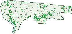
Green: 10 m cells where trees dominate, satellite 2021. Blue: water. The line is the suburb boundary.
| Canopy share, 1 m canopy height map, 2020 | 4.6% |
|---|---|
| Land with trees, 10 m satellite map, 2021 | 10.3% |
Demographics
Unemployment 4.6% · Labour-force participation 68.8%
Population by age in Ascot Vale
| 0-4 | 968 |
|---|---|
| 5-14 | 1,712 |
| 15-19 | 660 |
| 20-24 | 940 |
| 25-34 | 2,651 |
| 35-44 | 2,506 |
| 45-54 | 2,149 |
| 55-64 | 1,704 |
| 65-74 | 1,117 |
| 75-84 | 554 |
| 85+ | 228 |
Dwelling types in Ascot Vale
| House | 2,743 |
|---|---|
| Townhouse | 1,369 |
| Apartment | 1,829 |
| Other | 22 |
Households by weekly income in Ascot Vale
| <$650 | 872 |
|---|---|
| $650-1,499 | 1,176 |
| $1,500-2,999 | 1,484 |
| $3,000+ | 2,120 |
Top ancestries in Ascot Vale
| English | 4,099 |
|---|---|
| Australian | 3,926 |
| Other | 2,395 |
| Irish | 2,136 |
| Italian | 1,567 |
| Scottish | 1,359 |
Housing tenure in Ascot Vale
| Owned | 1,613 |
|---|---|
| Mortgage | 1,951 |
| Rented | 2,262 |
| Other | 58 |
Cars per household in Ascot Vale
| 0 | 706 |
|---|---|
| 1 | 2,727 |
| 2 | 1,901 |
| 3 | 401 |
| 4+ | 143 |
Commute to work in Ascot Vale
| Car | 2,880 |
|---|---|
| Train | 217 |
| Bus | 21 |
| Tram/ferry | 162 |
| Walked | 151 |
| Bicycle | 147 |
| Home | 3,268 |
Top countries of birth in Ascot Vale
| Vietnam | 397 |
|---|---|
| England | 349 |
| Italy | 302 |
| China | 238 |
| New Zealand | 233 |
| India | 196 |
Languages used at home in Ascot Vale
| Italian | 466 |
|---|---|
| Vietnamese | 465 |
| Greek | 312 |
| Cantonese | 284 |
| Mandarin | 244 |
| Arabic | 236 |
Birds & Wildlife Nearby
373,290 bird observations recorded near Ascot Vale — most often seen:
- Common Myna (18,803)
- Rainbow Lorikeet (18,625)
- Red Wattlebird (16,902)
- Magpie-lark (16,636)
- Little Raven (16,391)
- Rock Dove (16,079)
- Noisy Miner (15,723)
- Spotted Turtle-dove (14,823)
- Silver Gull (14,541)
- Dusky Moorhen (13,841)
- Common Starling (13,810)
- Eurasian Blackbird (13,516)
- Australian Magpie (13,505)
Show all 30 birds recorded near Ascot Vale
- Pacific Black Duck (13,285)
- Welcome Swallow (13,267)
- White-plumed Honeyeater (12,805)
- Superb Fairy-wren (11,970)
- House Sparrow (11,146)
- Chestnut Teal (11,128)
- Eurasian Coot (10,847)
- Crested Pigeon (10,549)
- Willie Wagtail (10,510)
- New Holland Honeyeater (10,389)
- Australasian Purple Swamphen (9,995)
- Australian White Ibis (9,410)
- Australasian Grebe (7,690)
- Galah (6,989)
- Grey Butcherbird (6,826)
- Bell Miner (6,822)
- Pied Currawong (6,467)
Sightings reported by observers, not a survey, so the counts show what people record rather than what lives here. Source: Atlas of Living Australia.
Nearby Suburbs
The closest suburbs to Ascot Vale:
- Flemington (1.4 km)
- Moonee Ponds (1.4 km)
- Travancore (1.9 km)
- Kensington (2.1 km)
- Maribyrnong (2.4 km)
- Aberfeldie (2.6 km)
- Footscray (2.9 km)
- Brunswick West (2.9 km)
Embed this suburb
Add this free Ascot Vale stat card to your own site — just copy the code:
Preview:
Cite this page
Quoting these figures? Copy the credit line:
Keep an eye on Ascot Vale
One email when this data meaningfully changes — new census figures, prices, rankings. No spam, unsubscribe anytime.
Streets
- Adelaide Street (6)
- Ailsa Street (21)
- Anderson Street (21)
- Angler Parade (28)
- Archer Avenue (47)
- Ascot Street (125)
- Ascot Vale Road (237)
- Aspect Avenue (18)
- Ayr Street (15)
- Bank Street (60)
- Banum Crescent (29)
- Bayview Terrace (28)
- Bettina Court (8)
- Bingham Way (1)
- Blamey Street (66)
- Bloomfield Road (123)
- Bowden Street (10)
- Bower Street (13)
- Brisbane Street (65)
- Brown Avenue (61)
- Brunton Street (8)
- Burrowes Street (76)
- Burton Crescent (17)
- Charles Street (140)
- Chauvel Street (7)
- Churchill Avenue (305)
- Clissold Street (2)
- Crockford Lane (1)
- Crown Terrace (10)
- Cunningham Court (17)
- Dalgety Drive (55)
- Dalgleish Street (1)
- Doncaster Street (92)
- Dumblane Avenue (22)
- Dunlop Avenue (376)
- Dutton Lane (24)
- East Street (16)
- Eden Court (15)
- Elliott Street (46)
- Enclave Avenue (23)
- Epsom Road (459)
- Farncomb Street (9)
- Federation Street (20)
- Fenton Street (108)
- Ferguson Street (29)
- Fernhill Street (8)
- Filson Street (46)
- Fisher Parade (214)
- Francis Street (117)
- Geddes Street (46)
- Gillespie Avenue (37)
- Gladswood Street (8)
- Harding Street (26)
- Harmony Road (29)
- Harold Street (58)
- Haven Crescent (35)
- Hillside Terrace (12)
- Hockey Lane (34)
- Holdsworth Street (12)
- Hunt Crescent (29)
- Hurtle Street (82)
- James Street (18)
- Kelvin Street (9)
- Kent Street (200)
- Kingston Avenue (19)
- Kirk Street (8)
- Langs Road (96)
- Leonard Crescent (171)
- Macarthur Avenue (4)
- Macarthur1 Avenue (4)
- Maribyrnong Road (336)
- Mascoma Street (93)
- Mccully Street (25)
- Medley Walk (12)
- Middle Street (103)
- Milton Street (68)
- Mirams Street (83)
- Monash Street (68)
- Moonee Street (59)
- Morphett Avenue (29)
- Morphett Walk (4)
- Morshead Street (41)
- Mt Alexander Road (157)
- Munro Street (144)
- Myrnong Crescent (87)
- Myross Avenue (55)
- Nairn Avenue (38)
- Newsom Street (101)
- North Street (177)
- Oriana Court (1)
- Ormond Road (119)
- Pentland Street (12)
- Portal Street (24)
- Province Lane (1)
- Queens Avenue (20)
- Railway Place E (3)
- Regent Street (51)
- Retreat Drive (26)
- River Avenue (29)
- Roseberry Street (176)
- Rothwell Street (44)
- Roxburgh Street (66)
- Sanctuary Walk (17)
- Sanctuary Way (11)
- Sandown Road (220)
- Savige Street (57)
- Selbourne Street (12)
- South Street (101)
- St Leonards Road (240)
- Stanford Street (23)
- Station Avenue (29)
- Sturdee Street (2)
- Sydney Street (25)
- Tasma Street (3)
- The Crescent (42)
- The Grove (15)
- The Parade (307)
- Tregunter Street (10)
- Union Road (530)
- Unley Grove (19)
- Vasey Street (54)
- Victory Parade (8)
- Waller Court (12)
- Walter Street (181)
- Waratah Street (19)
- Warrick Street (73)
- West Street (6)
- Wigton Street (26)
- Wingate Avenue (167)
- Woods Street (61)