Kalkallo VIC 3064
5,512 addresses · 210 streets
Calwell Electorate › Hume LGA › Kalkallo · 32 km from Melbourne
📦 Thinking of moving here? Read the Kalkallo moving guide

Living Here
Kalkallo is a suburb of Victoria, home to about 5,548 people, with a median age of 30. The typical household earns around $2,047 a week, with median rent near $400 a week. Most homes are houses. About 78% of households own their home and 22% rent. Most workers drive to work. Common community backgrounds include Indian, Australian, English. On the ABS socio-economic scale it sits in decile 7 of 10 nationally — a mid-range area. The median house sells for about $640,000.
Over time — Census 2001 → 2021
Dashed line: district figures for the Craigieburn - Mickleham statistical area (SA2), the smallest area the ABS published before 2011. Solid line: Kalkallo itself.
Getting Around & Local Services
10 schools
1 café or restaurant
1 supermarket
3 childcare & kindergartens
1 post office
1 golf club
1 playground
1 dog park
Getting around. Train station: Donnybrook, 2.1 km south-east · Airport: Melbourne Airport, 19.8 km south-west.
Sport & Recreation
1 facility recorded in Kalkallo.
- John Laffen Memorial Reserve Cricket
Socio-economic Standing
Deciles from 1 (lowest) to 10 (highest), against all Australian suburbs. The overall figure weighs advantage and disadvantage together; economic resources counts income and housing, and education & jobs counts qualifications and occupation. They often differ. Source: ABS SEIFA 2021.
Median Sale Prices
Median of recorded sales in the period, not a valuation. Source: Victorian Property Sales Report, Land Use Victoria.
Tree cover
🌳 Tree canopy: 2.6% share of land under canopy · satellite map, 2020
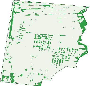
Green: 10 m cells where trees dominate, satellite 2021. Blue: water. The line is the suburb boundary.
| Canopy share, 1 m canopy height map, 2020 | 2.6% |
|---|---|
| Land with trees, 10 m satellite map, 2021 | 9.5% |
Demographics
Unemployment 4.7% · Labour-force participation 71.5%
Population by age in Kalkallo
| 0-4 | 794 |
|---|---|
| 5-14 | 803 |
| 15-19 | 186 |
| 20-24 | 314 |
| 25-34 | 1,568 |
| 35-44 | 1,137 |
| 45-54 | 367 |
| 55-64 | 230 |
| 65-74 | 113 |
| 75-84 | 35 |
| 85+ | 7 |
Dwelling types in Kalkallo
| House | 1,587 |
|---|---|
| Townhouse | 37 |
| Apartment | 0 |
| Other | 0 |
Households by weekly income in Kalkallo
| <$650 | 65 |
|---|---|
| $650-1,499 | 376 |
| $1,500-2,999 | 787 |
| $3,000+ | 309 |
Top ancestries in Kalkallo
| Other | 2,003 |
|---|---|
| Indian | 1,113 |
| Australian | 917 |
| English | 706 |
| Ancestry NS | 386 |
| Italian | 283 |
Housing tenure in Kalkallo
| Owned | 81 |
|---|---|
| Mortgage | 1,166 |
| Rented | 345 |
| Other | 8 |
Cars per household in Kalkallo
| 0 | 13 |
|---|---|
| 1 | 440 |
| 2 | 873 |
| 3 | 205 |
| 4+ | 66 |
Commute to work in Kalkallo
| Car | 1,764 |
|---|---|
| Train | 37 |
| Bus | 7 |
| Tram/ferry | 4 |
| Walked | 3 |
| Bicycle | 0 |
| Home | 467 |
Top countries of birth in Kalkallo
| India | 1,409 |
|---|---|
| Philippines | 156 |
| New Zealand | 122 |
| Iraq | 98 |
| Pakistan | 98 |
| Sri Lanka | 68 |
Languages used at home in Kalkallo
| Punjabi | 1,538 |
|---|---|
| Hindi | 183 |
| Urdu | 137 |
| Arabic | 128 |
| Samoan | 86 |
| Sinhalese | 78 |
Birds & Wildlife Nearby
2,140 bird observations recorded near Kalkallo — most often seen:
- Common Starling (183)
- Little Raven (178)
- Common Myna (154)
- Australian Magpie (145)
- Magpie-lark (103)
- House Sparrow (89)
- Black-shouldered Kite (80)
- European Goldfinch (69)
- Red Wattlebird (68)
- White-faced Heron (68)
- Rock Dove (65)
- Southern Victoria Australian Magpie (65)
- Welcome Swallow (65)
Show all 30 birds recorded near Kalkallo
- Brown Falcon (63)
- Eurasian Skylark (63)
- White-plumed Honeyeater (58)
- Willie Wagtail (55)
- Superb Fairy-wren (54)
- Eurasian Blackbird (50)
- Galah (50)
- Australian Wood Duck (48)
- Red-rumped Parrot (45)
- Yellow-rumped Thornbill (45)
- Pacific Black Duck (43)
- Masked Lapwing (42)
- Crested Pigeon (41)
- Wedge-tailed Eagle (40)
- Nankeen Kestrel (38)
- Rainbow Lorikeet (37)
- Eastern Rosella (36)
Sightings reported by observers, not a survey, so the counts show what people record rather than what lives here. Source: Atlas of Living Australia.
Nearby Suburbs
The closest suburbs to Kalkallo:
- Donnybrook (3.2 km)
- Beveridge (5.3 km)
- Mickleham (6 km)
- Woodstock (6.2 km)
- Craigieburn (8.1 km)
- Eden Park (10 km)
- Wollert (10.1 km)
- Yuroke (10.4 km)
Embed this suburb
Add this free Kalkallo stat card to your own site — just copy the code:
Preview:
Cite this page
Quoting these figures? Copy the credit line:
Keep an eye on Kalkallo
One email when this data meaningfully changes — new census figures, prices, rankings. No spam, unsubscribe anytime.
Streets
- Ajax Road (9)
- Alisterus Road (26)
- Antares Parade (127)
- Arcturus Drive (109)
- Argon Street (31)
- Arrowsmith Street (5)
- Ashnova Street (27)
- Ayudha Street (13)
- Azalea Walk (26)
- Balnarring Street (10)
- Bells Avenue (63)
- Bihu Walk (8)
- Bismuth Street (21)
- Bittersweet Drive (66)
- Blayney Street (9)
- Bloodwood Street (32)
- Bookham Circuit (23)
- Bowery Road (38)
- Brewster Drive (27)
- Brophy Road (18)
- Brucato Road (24)
- Bunting Crescent (61)
- Camden Drive (13)
- Camellia Walk (5)
- Cameron Street (2)
- Canopus Street (14)
- Caprara Street (19)
- Carex Drive (14)
- Carnsew Street (14)
- Cassette Street (27)
- Cassowary Street (12)
- Cephei Street (18)
- Chamomile Road (22)
- Chive Road (16)
- Cilantro Street (42)
- Claude Street (19)
- Code Street (5)
- Columbus Road (38)
- Comarty Crescent (45)
- Conebush Street (15)
- Cooney Circuit (46)
- Coronation Walk (22)
- Crepe Road (21)
- Cromarty Crescent (59)
- Cromarty Street (17)
- Currawong Street (19)
- Danzig Street (40)
- Dermody Avenue (42)
- Dermody Drive (22)
- Design Way (37)
- Desmodium Way (14)
- Dianella Avenue (19)
- Dodson Way (18)
- Donnybrook Road (30)
- Durant Circuit (36)
- Dussehra Street (11)
- Dwarf Road (15)
- Dwyer Street (192)
- Edgedell Avenue (31)
- Edgedell Road (8)
- Elbrus Road (13)
- Eltes Street (4)
- Euclid Road (19)
- Eureka Street (19)
- Fadaro Drive (49)
- Fadaro Street (49)
- Faston Road (14)
- Fenska Street (32)
- Fig Lane (1)
- Firewheel Road (31)
- Firnberg Road (19)
- Fisico Road (7)
- Fitzpatrick Circuit (63)
- Flame Road (18)
- Frankel Road (16)
- Fuchsia Walk (17)
- Fuchsia Way (17)
- Fuji Street (7)
- Furphy Walk (10)
- Furphy Way (10)
- Gandhi Walk (8)
- Gemsig Road (7)
- Goodman Avenue (49)
- Greaves Crescent (33)
- Guava Street (18)
- Gundagai Circuit (38)
- Gunns Gully Road (1)
- Hackney Way (31)
- Handlen Avenue (22)
- Handlen Street (17)
- Harslett Street (14)
- Herbert Street (1)
- Holbrook Crescent (25)
- Humboldt Street (13)
- Hume Freeway (58)
- Hunter Street (25)
- Ibera Way (7)
- Icarus Drive (29)
- Inglis Place (5)
- Inkspell Street (16)
- Jaffa Street (17)
- Jilcunda Street (18)
- Jump Street (24)
- Kaleno Way (13)
- Kales Court (12)
- Karthikai Walk (8)
- Kelberg Road (85)
- Kestrel Street (22)
- Kips Street (8)
- Klandy Drive (62)
- Kleberg Road (35)
- Knockturn Road (25)
- Koeks Vista (32)
- Laurina Street (23)
- Litoria Way (26)
- Lobb Street (9)
- Lockerbie Street (37)
- Lumin Boulevard (40)
- Lusco Street (21)
- Mackenzie Street (1)
- Magnesium Road (28)
- Malay Drive (8)
- Malcolm Street (23)
- Margot Avenue (23)
- Margot Circuit (68)
- Maryland Road (33)
- Maximova Avenue (31)
- Mccrae Street (1)
- Mcinerney Road (19)
- Mckane Street (43)
- Metro Avenue (23)
- Mitchell Street (42)
- Molonglo Road (17)
- Morningside Road (9)
- Mowamba Street (9)
- Moxham Drive (76)
- Mudrooroo Circuit (34)
- Mudrooroo Street (1)
- Mulgrave Boulevard (52)
- Mulholland Street (25)
- Murrumbidgee Circuit (55)
- Myall Street (13)
- Nagambie Road (35)
- Naroon Drive (34)
- Nasturium Street (32)
- Neon Street (10)
- Nick Way (10)
- Nomad Road (37)
- Oakley Avenue (29)
- Octavia Street (30)
- Ohio Street (18)
- Onam Lane (5)
- Oodgeroo Road (37)
- Orange Road (17)
- Oxygen Street (20)
- Paper Walk (21)
- Parvin Place (4)
- Pascal Crescent (54)
- Patterson Street (2)
- Peck Place (10)
- Pennsylvania Street (18)
- Pippa Way (12)
- Pittsburgh Road (51)
- Pongal Road (35)
- Prestige Drive (11)
- Pronto Drive (9)
- Punchbowl Road (20)
- Queensborough Road (30)
- Quill Circuit (49)
- Railway Parade (178)
- Revival Place (5)
- Roscoe Avenue (40)
- Sagittarii Road (21)
- Sahlia Avenue (23)
- Saladin Street (13)
- Selenium Street (6)
- Sequoia Drive (43)
- Sodium Street (26)
- Souter Avenue (65)
- Springs Road (1)
- Stawell Street (1)
- Stevia Road (8)
- Stilt Street (35)
- Stute Crescent (1)
- Sunflower Walk (6)
- Suster Walk (7)
- Taketa Way (22)
- Tamarack Street (14)
- Thunder Drive (15)
- Times Street (32)
- Titanium Street (26)
- Toyon Road (78)
- Trophis Street (22)
- Tucholsky Drive (47)
- Tuglow Place (5)
- Tungsten Drive (65)
- Tuxworth Drive (26)
- Tweed Place (5)
- Ugadi Walk (8)
- Werriberri Street (14)
- Whistler Circuit (41)
- Winding Street (14)
- Xenon Road (39)
- Yaldwin Street (6)
- Yasuda Way (8)
- Yate Street (6)
- Yorkville Road (35)
- Yucca Road (14)
- Zelkova Road (28)
- Zelkova Street (28)