Beveridge VIC 3753
6,745 addresses · 293 streets
McEwen Electorate › Mitchell LGA › Beveridge · 37 km from Melbourne
📦 Thinking of moving here? Read the Beveridge moving guide

Living Here
Beveridge is a suburb of Victoria, home to about 4,642 people, with a median age of 32. The typical household earns around $2,266 a week, with median rent near $400 a week. Most homes are houses. About 82% of households own their home and 18% rent. Most workers drive to work. Common community backgrounds include Australian, English, Italian. On the ABS socio-economic scale it sits in decile 7 of 10 nationally — a mid-range area. The median house sells for about $670,000.
Over time — Census 2001 → 2021
Dashed line: district figures for the Wallan statistical area (SA2), the smallest area the ABS published before 2011. Solid line: Beveridge itself.
Getting Around & Local Services
1 café or restaurant
1 hospital
1 childcare centre
Getting around. Train station: Donnybrook, 7.2 km south · Airport: Melbourne Airport, 24.4 km south-west.
Sport & Recreation
1 facility recorded in Beveridge.
- Beveridge Reserve Netball, Tennis (Outdoor)
Socio-economic Standing
Deciles from 1 (lowest) to 10 (highest), against all Australian suburbs. The overall figure weighs advantage and disadvantage together; economic resources counts income and housing, and education & jobs counts qualifications and occupation. They often differ. Source: ABS SEIFA 2021.
Median Sale Prices
Median of recorded sales in the period, not a valuation. Source: Victorian Property Sales Report, Land Use Victoria.
Tree cover
🌳 Tree canopy: 3.3% share of land under canopy · satellite map, 2020
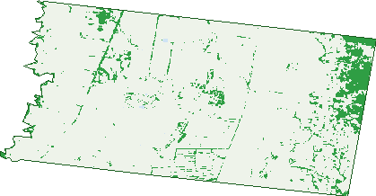
Green: 10 m cells where trees dominate, satellite 2021. Blue: water. The line is the suburb boundary.
| Canopy share, 1 m canopy height map, 2020 | 3.3% |
|---|---|
| Land with trees, 10 m satellite map, 2021 | 8.5% |
Demographics
Unemployment 4.4% · Labour-force participation 72.7%
Population by age in Beveridge
| 0-4 | 497 |
|---|---|
| 5-14 | 765 |
| 15-19 | 253 |
| 20-24 | 234 |
| 25-34 | 899 |
| 35-44 | 807 |
| 45-54 | 542 |
| 55-64 | 355 |
| 65-74 | 224 |
| 75-84 | 65 |
| 85+ | 10 |
Dwelling types in Beveridge
| House | 1,390 |
|---|---|
| Townhouse | 11 |
| Apartment | 0 |
| Other | 0 |
Households by weekly income in Beveridge
| <$650 | 79 |
|---|---|
| $650-1,499 | 267 |
| $1,500-2,999 | 580 |
| $3,000+ | 384 |
Top ancestries in Beveridge
| Australian | 1,499 |
|---|---|
| English | 1,200 |
| Other | 917 |
| Italian | 378 |
| Irish | 366 |
| Indian | 304 |
Housing tenure in Beveridge
| Owned | 217 |
|---|---|
| Mortgage | 906 |
| Rented | 242 |
| Other | 8 |
Cars per household in Beveridge
| 0 | 14 |
|---|---|
| 1 | 248 |
| 2 | 691 |
| 3 | 268 |
| 4+ | 149 |
Commute to work in Beveridge
| Car | 1,579 |
|---|---|
| Train | 14 |
| Bus | 3 |
| Tram/ferry | 0 |
| Walked | 18 |
| Bicycle | 0 |
| Home | 382 |
Top countries of birth in Beveridge
| India | 323 |
|---|---|
| New Zealand | 103 |
| England | 87 |
| Philippines | 43 |
| Iraq | 39 |
| Italy | 38 |
Languages used at home in Beveridge
| Punjabi | 361 |
|---|---|
| Hindi | 81 |
| Italian | 68 |
| Arabic | 62 |
| Greek | 55 |
| Turkish | 48 |
Birds & Wildlife Nearby
1,846 bird observations recorded near Beveridge — most often seen:
- Little Raven (142)
- Common Starling (121)
- Australian Magpie (108)
- Magpie-lark (86)
- Common Myna (85)
- Welcome Swallow (79)
- Black-shouldered Kite (77)
- European Goldfinch (77)
- Eurasian Skylark (72)
- House Sparrow (71)
- White-faced Heron (64)
- Willie Wagtail (61)
- Masked Lapwing (59)
Show all 30 birds recorded near Beveridge
- Pacific Black Duck (59)
- Brown Falcon (56)
- Nankeen Kestrel (50)
- Southern Victoria Australian Magpie (48)
- Australian Wood Duck (46)
- Eurasian Blackbird (45)
- Superb Fairy-wren (45)
- Golden-headed Cisticola (43)
- Crested Pigeon (42)
- White-fronted Chat (42)
- Red Wattlebird (41)
- Straw-necked Ibis (41)
- Wedge-tailed Eagle (41)
- Galah (40)
- White-plumed Honeyeater (37)
- Yellow-rumped Thornbill (37)
- Eurasian Coot (31)
Sightings reported by observers, not a survey, so the counts show what people record rather than what lives here. Source: Atlas of Living Australia.
Nearby Suburbs
The closest suburbs to Beveridge:
- Kalkallo (5.3 km)
- Donnybrook (7.5 km)
- Wallan (7.5 km)
- Woodstock (9.2 km)
- Mickleham (9.6 km)
- Eden Park (9.6 km)
- Upper Plenty (10.3 km)
- Darraweit Guim (10.3 km)
Embed this suburb
Add this free Beveridge stat card to your own site — just copy the code:
Preview:
Cite this page
Quoting these figures? Copy the credit line:
Keep an eye on Beveridge
One email when this data meaningfully changes — new census figures, prices, rankings. No spam, unsubscribe anytime.
Streets
- 75 Stewart Street (1)
- Abbey Road (37)
- Aherlow Road (12)
- Alcove Way (25)
- Ambient Crescent (115)
- Ambrosia Way (36)
- Amegilla Road (25)
- Andestic Road (56)
- Angel Way (7)
- Apollo Avenue (21)
- Arrowsmith Street (71)
- Artesian Way (10)
- Ashwin Loop (48)
- Atherton Street (16)
- Aurora Street (21)
- Austral Street (44)
- Aviemore Street (12)
- Ayre Street (27)
- Azure Street (31)
- Ball Street (16)
- Balmore Street (41)
- Banyan Lane (1)
- Basalt Street (69)
- Beacon Close (38)
- Belleview Crescent (29)
- Bellyn Court (4)
- Beveridge Road (7)
- Blackwood Place (18)
- Blossom Way (10)
- Bluestone Drive (39)
- Bolete Street (16)
- Braconid Street (25)
- Brae Street (10)
- Braemore Place (12)
- Bristlecone Street (22)
- Bryony Way (5)
- Bulbine Place (10)
- Bumble Street (10)
- Burnett Drive (14)
- Bursaria Street (4)
- Bushanger Circuit (6)
- Bushranger Circuit (18)
- Caddy Way (4)
- Cameron Rise (10)
- Camerons Lane (37)
- Camus Road (33)
- Canary View (18)
- Cannich Street (9)
- Carney Court (8)
- Cascade Drive (58)
- Cashew Street (30)
- Catenary Street (25)
- Celestial Way (13)
- Centella Street (13)
- Cessnock Crescent (19)
- Clasts Street (4)
- Claymore Street (16)
- Clematis Drive (10)
- Colethe Road (21)
- Constable Street (28)
- Corbally Road (20)
- Cormac Road (3)
- Cormac Way (5)
- Coronidium Street (14)
- Cosgrove Drive (28)
- Cradle Road (3)
- Crimson Street (1)
- Croft Street (28)
- Crozier Road (16)
- Culbokie Street (6)
- Cumbungi Road (9)
- Cypress Crescent (24)
- Dalneigh Street (11)
- Dawn Avenue (7)
- Delma Court (10)
- Delta Road (15)
- Dingo Road (15)
- Divine Street (11)
- Domain Drive (82)
- Donovans Lane (8)
- Dotterel Street (10)
- Dundee Road (6)
- Dunvegan Road (10)
- Dusk Avenue (14)
- Dwyer Street (21)
- Easey Road (34)
- Echidna Drive (26)
- Egret Street (29)
- Elimbah Street (14)
- Elizabeth Place (13)
- Emperor Drive (1)
- Emu Drive (10)
- Eventide Avenue (12)
- Evergreen Road (26)
- Fairhaven Avenue (47)
- Fairview Street (15)
- Fairywren Avenue (27)
- Fethard Road (12)
- Flagstone Lane (2)
- Flock Road (15)
- Foot Street (4)
- Foreman Street (1)
- Fortitude Avenue (14)
- Foundary Circuit (43)
- Foundry Circuit (43)
- Fountain Drive (73)
- Fraser Road (25)
- Fringe Drive (17)
- Galah Chase (16)
- Glen Robin Court (6)
- Glenburnie Road (16)
- Glencoe Street (11)
- Goat Street (11)
- Gold Dust Road (22)
- Golf Links Drive (107)
- Goshawk Street (28)
- Grace Court (8)
- Grandview Court (12)
- Grants Road (4)
- Gunns Gully Road (6)
- Hacketts Road (20)
- Hairstreak Drive (1)
- Halycon Bend (37)
- Hideaway Lane (4)
- Hillcrest Road (49)
- Hillsborough Street (41)
- Hopbush Street (14)
- Horizon Way (16)
- Howitt Street (10)
- Hume Freeway (10)
- Hummock Circuit (46)
- Idyll Street (8)
- Imperial Circuit (28)
- Ingot Street (12)
- Inkcap Street (24)
- Inverness Drive (21)
- Janna Road (13)
- Kelly Street (26)
- Kestrel Street (11)
- Kilbarron Road (14)
- Kinross Street (29)
- Kite Street (10)
- Kookaburra Way (12)
- Lambkin Road (23)
- Leadbeater Circuit (80)
- Lewis Street (105)
- Liberty Crescent (31)
- Lillypilly Road (26)
- Lilypilly Road (26)
- Lineblue Drive (1)
- Linum Road (4)
- Lithgow Street (86)
- Lomond Street (31)
- Lucknow Drive (79)
- Lunar Street (9)
- Lynwood Drive (32)
- Lyra Avenue (22)
- Macgregor Road (20)
- Magnolia Crescent (29)
- Malcolm Street (26)
- Mallaig Drive (54)
- Mallaig Way (10)
- Malleefowl Boulevard (28)
- Malus View (9)
- Mandalay Circuit (424)
- Mannagum Drive (38)
- Mantel Green (6)
- Marasmius Street (9)
- Masonry Street (40)
- Mayfield Way (13)
- Mckinnon Street (12)
- Meander Way (8)
- Medallion Avenue (20)
- Melaleuca Boulevard (46)
- Merriang Road (51)
- Michelstown Road (15)
- Mimosa Drive (26)
- Minton Street (11)
- Mistral Way (39)
- Munong Place (7)
- Mural Way (3)
- Murnong Place (7)
- Murray Street (29)
- Mushroom Street (22)
- Muttonwood Road (9)
- Nankeen Loop (48)
- Neerim Street (8)
- Newpark Road (28)
- Nightfall Street (23)
- Noorat Road (10)
- Northern Highway (1)
- Numbat Drive (51)
- Oaklands Street (11)
- Oasis Crescent (2)
- Old Hume Highway (8)
- Old Sydney Road (20)
- Oleander Circuit (35)
- Orana Boulevard (19)
- Ore Place (2)
- Orion Street (6)
- Ossary Road (15)
- Outlaw Place (5)
- Pacific Grange (5)
- Paganica Street (29)
- Palladium Circle (57)
- Palm Circuit (72)
- Pandorea Street (41)
- Patterson Street (2)
- Pavees Road (12)
- Peppercress Loop (37)
- Peppercress Street (10)
- Perch Street (24)
- Picea Place (3)
- Piebald Street (3)
- Pinnacle Chase (51)
- Plana Street (20)
- Platypus Chase (36)
- Plenty (9)
- Plenty View (27)
- Poets Mews (8)
- Pomegranate Drive (16)
- Possum Drive (32)
- Priory Way (7)
- Privet Road (9)
- Quoll Road (35)
- Radiata Street (19)
- Ramble Close (2)
- Range Road (8)
- Raniformis Road (23)
- Rankin Street (12)
- Raven Circuit (33)
- Redbud Place (4)
- Redwood Crescent (1)
- Rhapsody Road (38)
- Rigby Drive (22)
- Rill Court (3)
- Ringtail Place (10)
- Russula Street (28)
- Sanctuary Circuit (35)
- Scoparia Court (7)
- Seaberry Road (12)
- Serenity Place (4)
- Shawlands Road (13)
- Sheep Street (30)
- Sheridan Court (4)
- Silvereye Circuit (34)
- Siren Street (6)
- Sirius Avenue (18)
- Skye Street (9)
- Snug Lane (3)
- Solar Street (41)
- Solomon Way (8)
- Spafield Road (71)
- Sparrowhawk Drive (14)
- Spinosa Road (33)
- Spire Crescent (26)
- Spring Street (33)
- Sprite Lane (30)
- Stance Street (19)
- Stewart Street (17)
- Suir Road (1)
- Suir Way (5)
- Sunflower Drive (52)
- Sunset Boulevard (6)
- Supernal Street (6)
- Swallowtail Circuit (20)
- Swamphen Place (13)
- Swamphen Street (20)
- Synod Drive (6)
- Tangara Road (31)
- Templemore Road (47)
- The Crest (5)
- Themeda Drive (2)
- Thornbill Lane (13)
- Thornton Street (10)
- Tilia Drive (26)
- Troopers Road (22)
- Tubifera Street (11)
- Tufted Street (18)
- Twilight Avenue (14)
- Vantage Green (13)
- Vega Avenue (22)
- Verdant Court (6)
- Waratah Street (21)
- Waterfall Crescent (6)
- Wattlebird Street (37)
- Waxflower Road (13)
- Wentworth Terrace (14)
- Whiteside Street (113)
- Willowleaf Street (56)
- Wirilda Drive (16)
- Yellow Fieldcap Road (23)
- Zenith Road (26)