Elwood VIC 3184
11,727 addresses · 90 streets
Macnamara Electorate › Port Phillip LGA › Elwood · 8 km from Melbourne
📦 Thinking of moving here? Read the Elwood moving guide

Living Here
A bayside inner-Melbourne suburb of art-deco apartments near the beach, Elwood is affluent and apartment-led. Small households of 1.9 people and a median age of 38 prevail. Median household income is $2,096 a week, with rent around $415.
Elwood is a suburb of Victoria, home to about 15,153 people, with a median age of 38. The typical household earns around $2,096 a week, with median rent near $415 a week. Most homes are apartments. About 47% of households own their home and 52% rent. Most workers work from home. Common community backgrounds include English, Australian, Irish. On the ABS socio-economic scale it sits in decile 10 of 10 nationally — a relatively advantaged area. The median house sells for about $2,075,000.
Over time — Census 2001 → 2021
Dashed line: district figures for the Elwood statistical area (SA2), the smallest area the ABS published before 2011. Solid line: Elwood itself.
Getting Around & Local Services
72 schools
39 Catholic churches
2 playgrounds
1 dog park
3 beauty salons
Getting around. Train station: Ripponlea, 900 m north-east · Tram stop: Stop 40: Scott Street, 650 m east · Bus interchange: Southern Cross Coach Terminal, 7.7 km north-west · Ferry wharf: St Kilda - Williamstown Ferry, 2.6 km north-west · Airport: Moorabbin Airport, 14.8 km south-east.
Sport & Recreation
4 facilities recorded in Elwood.
- Elsternwick Golf Course Golf
- Elwood Life Saving Club Surf Life Saving
- Elwood Reserve Australian Rules Football, Cricket, Croquet, Gaelic Football, Soccer, Tennis (Outdoor), Touch Football
- Elwood Sailing Club Sailing
Socio-economic Standing
Deciles from 1 (lowest) to 10 (highest), against all Australian suburbs. The overall figure weighs advantage and disadvantage together; economic resources counts income and housing, and education & jobs counts qualifications and occupation. They often differ. Source: ABS SEIFA 2021.
Median Sale Prices
Median of recorded sales in the period, not a valuation. Source: Victorian Property Sales Report, Land Use Victoria.
Tree cover
🌳 Tree canopy: 12.2% share of land under canopy · satellite map, 2020
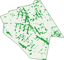
Green: 10 m cells where trees dominate, satellite 2021. Blue: water. The line is the suburb boundary.
| Canopy share, 1 m canopy height map, 2020 | 12.2% |
|---|---|
| Land with trees, 10 m satellite map, 2021 | 9.4% |
Demographics
Unemployment 4.1% · Labour-force participation 74.7%
Population by age in Elwood
| 0-4 | 697 |
|---|---|
| 5-14 | 1,279 |
| 15-19 | 517 |
| 20-24 | 721 |
| 25-34 | 3,301 |
| 35-44 | 2,841 |
| 45-54 | 2,401 |
| 55-64 | 1,779 |
| 65-74 | 1,042 |
| 75-84 | 425 |
| 85+ | 147 |
Dwelling types in Elwood
| House | 1,035 |
|---|---|
| Townhouse | 987 |
| Apartment | 5,239 |
| Other | 0 |
Households by weekly income in Elwood
| <$650 | 837 |
|---|---|
| $650-1,499 | 1,527 |
| $1,500-2,999 | 2,246 |
| $3,000+ | 2,315 |
Top ancestries in Elwood
| English | 5,560 |
|---|---|
| Australian | 3,966 |
| Irish | 2,403 |
| Other | 2,122 |
| Scottish | 1,927 |
| Italian | 1,019 |
Housing tenure in Elwood
| Owned | 1,513 |
|---|---|
| Mortgage | 1,897 |
| Rented | 3,731 |
| Other | 67 |
Cars per household in Elwood
| 0 | 812 |
|---|---|
| 1 | 4,009 |
| 2 | 1,917 |
| 3 | 319 |
| 4+ | 130 |
Commute to work in Elwood
| Car | 3,048 |
|---|---|
| Train | 194 |
| Bus | 51 |
| Tram/ferry | 157 |
| Walked | 239 |
| Bicycle | 218 |
| Home | 4,253 |
Top countries of birth in Elwood
| England | 775 |
|---|---|
| New Zealand | 356 |
| United States | 187 |
| Ireland | 176 |
| India | 145 |
| Italy | 143 |
Languages used at home in Elwood
| Spanish | 225 |
|---|---|
| Greek | 219 |
| Italian | 199 |
| French | 171 |
| Russian | 156 |
| German | 133 |
Birds & Wildlife Nearby
217,710 bird observations recorded near Elwood — most often seen:
- Rainbow Lorikeet (12,888)
- Common Myna (12,646)
- Little Raven (12,411)
- Rock Dove (11,826)
- Noisy Miner (11,373)
- Silver Gull (10,952)
- Magpie-lark (10,759)
- Australian Magpie (10,287)
- Red Wattlebird (9,425)
- Welcome Swallow (8,607)
- Pacific Black Duck (8,057)
- Little Pied Cormorant (7,926)
- Spotted Turtle-dove (7,774)
Show all 30 birds recorded near Elwood
- Common Starling (7,528)
- Dusky Moorhen (6,073)
- Eurasian Coot (6,003)
- Chestnut Teal (5,473)
- Eurasian Blackbird (5,400)
- Black Swan (5,386)
- Crested Pigeon (5,279)
- Australasian Purple Swamphen (5,214)
- Little Black Cormorant (4,738)
- Pied Currawong (4,470)
- Masked Lapwing (4,403)
- House Sparrow (4,157)
- Grey Butcherbird (4,011)
- Australian Wood Duck (3,866)
- Sulphur-crested Cockatoo (3,739)
- Little Wattlebird (3,635)
- Willie Wagtail (3,404)
Sightings reported by observers, not a survey, so the counts show what people record rather than what lives here. Source: Atlas of Living Australia.
Nearby Suburbs
The closest suburbs to Elwood:
- Ripponlea (0.8 km)
- Balaclava (1.4 km)
- Elsternwick (1.8 km)
- St Kilda (1.9 km)
- St Kilda East (2.1 km)
- Gardenvale (2.8 km)
- St Kilda West (2.8 km)
- Windsor (2.9 km)
Embed this suburb
Add this free Elwood stat card to your own site — just copy the code:
Preview:
Cite this page
Quoting these figures? Copy the credit line:
Keep an eye on Elwood
One email when this data meaningfully changes — new census figures, prices, rankings. No spam, unsubscribe anytime.
Streets
- Addison Street (236)
- Alfriston Street (69)
- Austin Avenue (89)
- Avoca Avenue (145)
- Avoca Court (26)
- Barkly Street (303)
- Barring Buluk Circuit (3)
- Bay View Street (1)
- Bayview Street (1)
- Beach Avenue (127)
- Bendigo Avenue (97)
- Bluff Avenue (52)
- Brighton Road (552)
- Broadway (375)
- Bronte Lane (3)
- Browning Street (36)
- Burns Street (65)
- Byrne Avenue (86)
- Byron Street (246)
- Clarke Street (67)
- Coleridge Street (76)
- Cyril Street (43)
- Dairy Lane (3)
- Daley Street (87)
- Dante Lane (4)
- Dickens Street (642)
- Docker Street (218)
- Dryden Street (12)
- Elwood Foreshore (2)
- Elwood Foreshore Road (4)
- Florence Lane (3)
- Foam Street (316)
- Garden Court (24)
- Glen Huntly Road (587)
- Goldsmith Street (110)
- Gordon Avenue (46)
- Greig Court (78)
- Hartpury Avenue (115)
- Hatters Lane (2)
- Head Street (1)
- Heaton Avenue (21)
- Hennessy Avenue (57)
- Hood Street (28)
- James Place (4)
- John Street (77)
- Joyce Street (57)
- Keats Street (8)
- Kendall Street (52)
- Kingsley Street (158)
- Knight Street (11)
- Lawson Street (12)
- Lindsay Avenue (20)
- Lytton Street (20)
- Marine Parade (133)
- Mason Avenue (48)
- May Street (71)
- Mccrae Street (14)
- Meredith Street (78)
- Milton Street (475)
- Mitford Street (371)
- Moore Street (46)
- Normandy Road (28)
- Ormond Esplanade (453)
- Ormond Road (866)
- Phyllis Street (6)
- Pine Avenue (301)
- Poets Grove (31)
- Pozieres Avenue (15)
- Rainsford Street (38)
- Robert Street (64)
- Rothesay Avenue (73)
- Ruskin Street (284)
- Scott Street (296)
- Selwyn Avenue (166)
- Shelley Street (174)
- Southey Court (21)
- Southey Grove (25)
- Southey Street (349)
- Spray Street (288)
- St Kilda Street (259)
- Tennyson Street (702)
- Thackeray Street (38)
- Tide Street (2)
- Tiuna Grove (187)
- Vautier Street (145)
- Warrain Loop (3)
- Wave Street (68)
- Wilkinson Lane (1)
- Wilton Grove (52)
- Wimbledon Avenue (79)