Elsternwick VIC 3185
6,997 addresses · 99 streets
Macnamara Electorate › Glen Eira LGA › Elsternwick · 9 km from Melbourne
📦 Thinking of moving here? Read the Elsternwick moving guide

Living Here
Elsternwick is a suburb of Victoria, home to about 10,887 people, with a median age of 38. The typical household earns around $2,209 a week, with median rent near $441 a week. Most homes are apartments. About 60% of households own their home and 39% rent. Most workers work from home. Common community backgrounds include English, Australian, Irish. On the ABS socio-economic scale it sits in decile 10 of 10 nationally — a relatively advantaged area. The median house sells for about $1,953,000.
Over time — Census 2001 → 2021
Dashed line: district figures for the Elsternwick statistical area (SA2), the smallest area the ABS published before 2011. Solid line: Elsternwick itself.
Getting Around & Local Services
84 schools
37 Catholic churches
12 childcare & kindergartens
2 playgrounds
1 dog park
Getting around. Train station: Elsternwick, 500 m west · Tram stop: Stop 46: Orrong Road, 50 m north-west · Bus interchange: Chadstone Shopping Centre, 6.8 km east · Ferry wharf: St Kilda - Williamstown Ferry, 4.3 km north-west · Airport: Moorabbin Airport, 13.2 km south-east.
Sport & Recreation
5 facilities recorded in Elsternwick.
- 6 Degrees South Health & Fitness Fitness / Gymnasium Workouts
- EFM Health & Fitness Club Fitness / Gymnasium Workouts
- Elsternwick Bowls Club Lawn Bowls
- Elsternwick Croquet Club Croquet
- Sage Institute of Fitness Fitness / Gymnasium Workouts
Socio-economic Standing
Deciles from 1 (lowest) to 10 (highest), against all Australian suburbs. The overall figure weighs advantage and disadvantage together; economic resources counts income and housing, and education & jobs counts qualifications and occupation. They often differ. Source: ABS SEIFA 2021.
Median Sale Prices
Median of recorded sales in the period, not a valuation. Source: Victorian Property Sales Report, Land Use Victoria.
Tree cover
🌳 Tree canopy: 8.4% share of land under canopy · satellite map, 2020
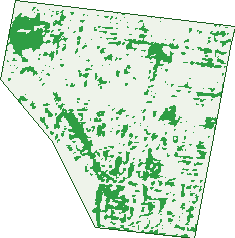
Green: 10 m cells where trees dominate, satellite 2021. Blue: water. The line is the suburb boundary.
| Canopy share, 1 m canopy height map, 2020 | 8.4% |
|---|---|
| Land with trees, 10 m satellite map, 2021 | 14.8% |
Demographics
Unemployment 3.5% · Labour-force participation 69.4%
Population by age in Elsternwick
| 0-4 | 560 |
|---|---|
| 5-14 | 1,285 |
| 15-19 | 599 |
| 20-24 | 599 |
| 25-34 | 1,846 |
| 35-44 | 1,538 |
| 45-54 | 1,468 |
| 55-64 | 1,220 |
| 65-74 | 991 |
| 75-84 | 519 |
| 85+ | 256 |
Dwelling types in Elsternwick
| House | 1,733 |
|---|---|
| Townhouse | 873 |
| Apartment | 1,875 |
| Other | 45 |
Households by weekly income in Elsternwick
| <$650 | 570 |
|---|---|
| $650-1,499 | 891 |
| $1,500-2,999 | 1,255 |
| $3,000+ | 1,588 |
Top ancestries in Elsternwick
| English | 3,277 |
|---|---|
| Australian | 2,989 |
| Other | 2,116 |
| Irish | 1,459 |
| Scottish | 1,013 |
| Polish | 556 |
Housing tenure in Elsternwick
| Owned | 1,386 |
|---|---|
| Mortgage | 1,280 |
| Rented | 1,747 |
| Other | 64 |
Cars per household in Elsternwick
| 0 | 448 |
|---|---|
| 1 | 2,187 |
| 2 | 1,446 |
| 3 | 287 |
| 4+ | 118 |
Commute to work in Elsternwick
| Car | 1,977 |
|---|---|
| Train | 234 |
| Bus | 30 |
| Tram/ferry | 34 |
| Walked | 179 |
| Bicycle | 55 |
| Home | 2,729 |
Top countries of birth in Elsternwick
| England | 437 |
|---|---|
| New Zealand | 216 |
| South Africa | 202 |
| Ireland | 154 |
| India | 139 |
| China | 129 |
Languages used at home in Elsternwick
| Greek | 224 |
|---|---|
| Russian | 194 |
| Mandarin | 172 |
| French | 150 |
| Italian | 131 |
| Japanese | 122 |
Birds & Wildlife Nearby
144,123 bird observations recorded near Elsternwick — most often seen:
- Rainbow Lorikeet (10,614)
- Little Raven (9,288)
- Common Myna (8,966)
- Noisy Miner (8,926)
- Rock Dove (8,363)
- Australian Magpie (7,016)
- Magpie-lark (6,877)
- Red Wattlebird (6,847)
- Silver Gull (6,847)
- Spotted Turtle-dove (5,987)
- Welcome Swallow (5,219)
- Common Starling (4,732)
- Pacific Black Duck (4,374)
Show all 30 birds recorded near Elsternwick
- Little Pied Cormorant (4,349)
- Eurasian Blackbird (3,706)
- Grey Butcherbird (3,627)
- Chestnut Teal (3,525)
- Pied Currawong (3,465)
- Little Wattlebird (3,411)
- Crested Pigeon (3,154)
- Dusky Moorhen (2,932)
- Brown Thornbill (2,777)
- Southern Victoria Australian Magpie (2,776)
- Australian Wood Duck (2,762)
- Australasian Purple Swamphen (2,639)
- Little Black Cormorant (2,373)
- Eurasian Coot (2,338)
- House Sparrow (2,178)
- Crested Tern (2,102)
- Pied Cormorant (1,953)
Sightings reported by observers, not a survey, so the counts show what people record rather than what lives here. Source: Atlas of Living Australia.
Nearby Suburbs
The closest suburbs to Elsternwick:
- Ripponlea (1.3 km)
- Gardenvale (1.4 km)
- Caulfield (1.7 km)
- Caulfield South (1.8 km)
- Elwood (1.8 km)
- Balaclava (2 km)
- Caulfield North (2.2 km)
- St Kilda East (2.3 km)
Embed this suburb
Add this free Elsternwick stat card to your own site — just copy the code:
Preview:
Cite this page
Quoting these figures? Copy the credit line:
Keep an eye on Elsternwick
One email when this data meaningfully changes — new census figures, prices, rankings. No spam, unsubscribe anytime.
Streets
- Acacia Street (22)
- Alexandra Avenue (71)
- Allison Road (164)
- Archibald Street (6)
- Baxter Street (11)
- Bayview Street (23)
- Beavis Street (206)
- Bent Street (5)
- Bertram Street (110)
- Blanche Street (36)
- Brentani Avenue (13)
- Bruce Court (6)
- Burreel Avenue (10)
- Buxton Street (16)
- Calista Court (6)
- Carlingford Street (49)
- Carre Street (58)
- Charles Street (36)
- Clarence Street (165)
- Clonard Avenue (12)
- College Street (126)
- Curral Place (3)
- Curral Road (19)
- Davis Street (17)
- Denver Crescent (21)
- Downshire Road (114)
- Duffy Avenue (10)
- Eastaway Street (3)
- Edward Street (56)
- Elizabeth Street (90)
- Elm Avenue (33)
- Elm Street (3)
- Elster Avenue (37)
- Elsternwick Place (7)
- Foster Street (6)
- Garden Street (11)
- Gisborne Street (19)
- Gladstone Parade (53)
- Glen Eira Road (278)
- Glen Huntly Road (1,237)
- Gordon Street (168)
- Gough Street (16)
- Grafton Street (27)
- Hartington Street (87)
- Hendra Court (5)
- Hoddle Street (75)
- Hopetoun Street (49)
- Horne Street (101)
- Hotham Street (45)
- King Street (46)
- Kooyong Road (198)
- Leslie Street (24)
- Liscard Street (35)
- Long Street (28)
- Main Street (24)
- Marmara Drive (7)
- May Street (2)
- Maysbury Avenue (28)
- Mccombie Street (106)
- Mcmillan Street (43)
- Meaney Street (8)
- Miller Street (1)
- Morton Street (2)
- Mulgrave Street (31)
- Murray Street (52)
- Nagle Avenue (7)
- Nepean Highway (196)
- Oak Avenue (14)
- Orrong Road (377)
- Oswald Street (89)
- Park Street (62)
- Parkside Street (158)
- Parnell Street (75)
- Prahran Grove (81)
- Prentice Street (56)
- Regent Street (97)
- Riddell Parade (203)
- Ripon Grove (38)
- Ross Street (40)
- Rowan Street (13)
- Rupert Street (8)
- Rusden Street (33)
- Sandham Court (5)
- Sandham Street (42)
- Selwyn Street (26)
- Seymour Road (207)
- Sherbrooke Avenue (11)
- Shoobra Road (150)
- Sinclair Street (31)
- Somerset Street (13)
- St Georges Road (183)
- St James Parade (37)
- Staniland Grove (30)
- Stanley Street (36)
- Trevelyan Street (95)
- Victoria Street (113)
- Villiers Street (31)
- Willow Street (18)
- Yorston Court (46)