Bannockburn VIC 3331
3,175 addresses · 167 streets
Corangamite Electorate › Golden Plains LGA › Bannockburn · 74 km from Melbourne
📦 Thinking of moving here? Read the Bannockburn moving guide

Living Here
Bannockburn is a suburb of Victoria, home to about 6,470 people, with a median age of 35. The typical household earns around $2,055 a week, with median rent near $390 a week. Most homes are houses. About 88% of households own their home and 11% rent. Most workers drive to work. Common community backgrounds include Australian, English, Scottish. On the ABS socio-economic scale it sits in decile 6 of 10 nationally — a mid-range area. The median house sells for about $712,500.
Over time — Census 2001 → 2021
Dashed line: district figures for the Bannockburn statistical area (SA2), the smallest area the ABS published before 2011. Solid line: Bannockburn itself.
Getting Around & Local Services
2 supermarkets
1 pharmacy
1 medical clinic
1 childcare centre
1 library
1 post office
3 service stations
2 gyms & sports centres
1 golf club
1 playground
2 bakeries
1 butcher
1 hairdresser
1 mechanic
Getting around. Airport: Avalon Airport, 26.5 km east.
Sport & Recreation
7 facilities recorded in Bannockburn.
- Bannockburn & District Bowls Club Lawn Bowls
- Bannockburn Community Sports Stadium Badminton, Basketball, Carpet Bowls, Gymnastics, Netball (Indoor), Soccer (Indoor Soccer / Futsal)
- Bannockburn Golf Club Golf
- Bannockburn Recreation Centre Badminton, Basketball, Carpet Bowls, Gymnastics, Netball (Indoor), Soccer (Indoor Soccer / Futsal)
- Bannockburn Tennis Courts (Milton Street) Tennis (Outdoor)
- Bannockburn Tennis Courts (Moore Street) Tennis (Outdoor)
- Bannockburn Victoria Park Recreation Reserve Australian Rules Football, BMX, Cricket, Netball, Skating, Soccer, Tennis (Outdoor)
Socio-economic Standing
Deciles from 1 (lowest) to 10 (highest), against all Australian suburbs. The overall figure weighs advantage and disadvantage together; economic resources counts income and housing, and education & jobs counts qualifications and occupation. They often differ. Source: ABS SEIFA 2021.
Median Sale Prices
Median of recorded sales in the period, not a valuation. Source: Victorian Property Sales Report, Land Use Victoria.
Tree cover
🌳 Tree canopy: 8.9% share of land under canopy · satellite map, 2020
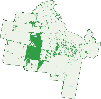
Green: 10 m cells where trees dominate, satellite 2021. Blue: water. The line is the suburb boundary.
| Canopy share, 1 m canopy height map, 2020 | 8.9% |
|---|---|
| Land with trees, 10 m satellite map, 2021 | 13.1% |
Demographics
Unemployment 2.9% · Labour-force participation 68.1%
Population by age in Bannockburn
| 0-4 | 511 |
|---|---|
| 5-14 | 1,114 |
| 15-19 | 426 |
| 20-24 | 281 |
| 25-34 | 815 |
| 35-44 | 981 |
| 45-54 | 847 |
| 55-64 | 560 |
| 65-74 | 545 |
| 75-84 | 276 |
| 85+ | 117 |
Dwelling types in Bannockburn
| House | 1,964 |
|---|---|
| Townhouse | 83 |
| Apartment | 3 |
| Other | 0 |
Households by weekly income in Bannockburn
| <$650 | 209 |
|---|---|
| $650-1,499 | 470 |
| $1,500-2,999 | 744 |
| $3,000+ | 480 |
Top ancestries in Bannockburn
| Australian | 2,939 |
|---|---|
| English | 2,672 |
| Scottish | 712 |
| Irish | 711 |
| German | 324 |
| Other | 309 |
Housing tenure in Bannockburn
| Owned | 606 |
|---|---|
| Mortgage | 1,180 |
| Rented | 228 |
| Other | 21 |
Cars per household in Bannockburn
| 0 | 20 |
|---|---|
| 1 | 402 |
| 2 | 930 |
| 3 | 375 |
| 4+ | 312 |
Commute to work in Bannockburn
| Car | 2,176 |
|---|---|
| Train | 6 |
| Bus | 6 |
| Tram/ferry | 0 |
| Walked | 37 |
| Bicycle | 3 |
| Home | 465 |
Top countries of birth in Bannockburn
| England | 218 |
|---|---|
| New Zealand | 69 |
| Netherlands | 30 |
| Scotland | 26 |
| Germany | 21 |
| South Africa | 21 |
Languages used at home in Bannockburn
| Croatian | 28 |
|---|---|
| Spanish | 15 |
| Italian | 12 |
| Serbian | 11 |
| Vietnamese | 11 |
| Cantonese | 10 |
Birds & Wildlife Nearby
16,721 bird observations recorded near Bannockburn — most often seen:
- Superb Fairy-wren (918)
- Red Wattlebird (897)
- New Holland Honeyeater (842)
- White-naped Honeyeater (824)
- White-plumed Honeyeater (771)
- Grey Fantail (692)
- Eastern Rosella (682)
- Grey Shrike-thrush (678)
- Little Raven (656)
- Galah (637)
- Willie Wagtail (629)
- Eastern Yellow Robin (591)
- Australian Magpie (563)
Show all 30 birds recorded near Bannockburn
- Yellow-faced Honeyeater (562)
- Eurasian Blackbird (557)
- Southern Victoria Australian Magpie (529)
- Weebill (502)
- Spotted Pardalote (492)
- Rufous Whistler (460)
- Restless Flycatcher (426)
- Brown-headed Honeyeater (422)
- Striated Pardalote (417)
- White-winged Chough (407)
- Common Bronzewing (406)
- Red-browed Finch (398)
- Brown Thornbill (368)
- Black-faced Cuckoo-shrike (367)
- Jacky Winter (357)
- Welcome Swallow (340)
- Long-billed Corella (331)
Sightings reported by observers, not a survey, so the counts show what people record rather than what lives here. Source: Atlas of Living Australia.
Nearby Suburbs
The closest suburbs to Bannockburn:
- Russells Bridge (4.7 km)
- Gheringhap (6.1 km)
- Sutherlands Creek (6.3 km)
- Murgheboluc (6.7 km)
- Lethbridge (10.1 km)
- Batesford (10.4 km)
- Moorabool (10.4 km)
- Stonehaven (10.6 km)
Embed this suburb
Add this free Bannockburn stat card to your own site — just copy the code:
Preview:
Cite this page
Quoting these figures? Copy the credit line:
Keep an eye on Bannockburn
One email when this data meaningfully changes — new census figures, prices, rankings. No spam, unsubscribe anytime.
Streets
- Alice Mews (33)
- Alvista Court (7)
- Andrews Court (13)
- Archer Way (16)
- Archie Lane (2)
- Avoca Court (11)
- Bakers Road (3)
- Balmaha Avenue (13)
- Bannockburn-maude Road (1)
- Bannockburn-shelford Road (11)
- Blacker Way (25)
- Bournbank Avenue (20)
- Bracher Road (11)
- Broadhead Way (38)
- Bruce Street (26)
- Bryan Place (6)
- Burns Street (25)
- Burnside Road (115)
- Burton Way (3)
- Byron Street (29)
- Cabernet Court (17)
- Camden Mews (10)
- Charlton Road (26)
- Chasseles Place (11)
- Clyde Hill Road (6)
- Clyde Road (65)
- Columbia Close (8)
- Connors Crescent (18)
- Cromwell Court (7)
- Cullen Court (8)
- Dalcruin Drive (21)
- Dann Road (7)
- Dardel Drive (58)
- Darriwell Drive (35)
- Davies Street (6)
- Denham Drive (1)
- Doherty Street (12)
- Dora Court (7)
- Douglass Court (9)
- Drystone Lane (7)
- Duviney Way (12)
- Eagle View Place (10)
- Eagleview Place (11)
- Earl Crescent (48)
- Edenborough Way (16)
- Edna Court (10)
- Ellis Place (2)
- Elrae Court (15)
- English Road (4)
- Erwin Court (6)
- Ewart Drive (13)
- Farrell Street (16)
- Fedke Place (2)
- Fenwick Fairway (18)
- Firetail Crescent (17)
- Flynn Way (7)
- Forthside Mews (9)
- Francis Court (4)
- Freeman Street (19)
- Garonne Drive (48)
- Geelong Road (46)
- Giles Drive (20)
- Gillett Street (1)
- Glastonbury Close (10)
- Glen Avon Drive (73)
- Glenbrae Court (11)
- Glennette Court (10)
- Gray Road (2)
- Guinane Court (11)
- Gurney Close (5)
- Gwendoline Court (19)
- Hamish Drive (34)
- Harmon Street (8)
- Harvey Road (23)
- Hazel Place (2)
- Herbert Way (19)
- Hermitage Place (11)
- High Street (95)
- Holder Road (54)
- Hooper Link (6)
- Hooper Way (8)
- Imperial Way (43)
- Inverlochy Drive (24)
- Jackson Court (7)
- James Place (22)
- Kelly Lane (2)
- Kelly Road (36)
- Kernot Street (17)
- Kintyre Court (15)
- Knights Park Crescent (37)
- Knowles Court (21)
- Laffan Court (4)
- Laurie Street (9)
- Le Maitre Drive (12)
- Lemalker Court (20)
- Leo Court (10)
- Levy Road (27)
- Lowndes Road (71)
- Lucien Place (13)
- Lynchs Road (3)
- Macrossan Avenue (21)
- Madden Road (2)
- Manifold Street (10)
- Maras Lane (25)
- Mason Road (3)
- Masons Road (3)
- Master Way (10)
- Mattheys Road (1)
- Mckenna Street (20)
- Mcphillips Road (84)
- Melissa Way (7)
- Merlot Court (13)
- Middleton Drive (21)
- Midland Highway (48)
- Milton Street (61)
- Moodie Court (5)
- Moore Street (21)
- Moreillon Boulevard (65)
- Moreillon Boulevarde (66)
- Mowbray Way (28)
- Munro Mews (10)
- Oban Lane (16)
- Old Base Road (11)
- Old Mill Road (6)
- Oliver Court (7)
- Ormond Street (6)
- Pilloud Street (15)
- Pope Street (76)
- Purchas Lane (2)
- Range Road (13)
- Riceflower Road (13)
- Riddles Road (5)
- Rosemond Way (37)
- Ruby Court (20)
- Russell Road (6)
- Ruxton Court (7)
- Saffin Court (11)
- Sandhurst Court (12)
- Scanlon Road (2)
- Scotland Court (19)
- Shekkleton Road (23)
- Shelford-bannockburn Road (5)
- Sherry Court (18)
- Sindarin Court (10)
- Somerset Court (26)
- Spring Creek Road (2)
- Stephens Road (7)
- Stevenson Road (73)
- Sun Orchid Grove (24)
- Sunset Way (4)
- Tanin Court (14)
- The Grange (11)
- Thomas Court (4)
- Trevena Ridge (15)
- Victor Street (22)
- Vintage Court (10)
- Wabdallah Way (5)
- Ware Street (27)
- Warrak Drive (23)
- Warwick Way (12)
- Water Ribbon View (17)
- Waterview Lane (2)
- Wattle Grove (6)
- Willowbrae Way (43)
- Woody Court (12)
- Xavier Avenue (7)
- Yverdon Drive (50)