Batesford VIC 3213
656 addresses · 46 streets
Corangamite Electorate › Golden Plains LGA › Batesford · 67 km from Melbourne
📦 Thinking of moving here? Read the Batesford moving guide

Living Here
Batesford is a suburb of Victoria, home to about 1,141 people, with a median age of 39. The typical household earns around $2,837 a week, with median rent near $325 a week. Most homes are houses. About 96% of households own their home and 3% rent. Most workers drive to work. Common community backgrounds include Australian, English, Irish. On the ABS socio-economic scale it sits in decile 10 of 10 nationally — a relatively advantaged area.
Over time — Census 2001 → 2021
Dashed line: district figures for the North Geelong - Bell Park statistical area (SA2), the smallest area the ABS published before 2011. Solid line: Batesford itself.
Getting Around & Local Services
1 library
2 service stations
1 gym
1 plumber
1 place to stay
Getting around. Train station: North Geelong, 7.5 km south-east · Ferry wharf: Spirit of Tasmania, 7.6 km east · Airport: Avalon Airport, 18.2 km east.
Sport & Recreation
2 facilities recorded in Batesford.
- Batesford Reserve Tennis (Outdoor)
- Bell Park Sports Club Motor Sports, Soccer
Socio-economic Standing
Deciles from 1 (lowest) to 10 (highest), against all Australian suburbs. The overall figure weighs advantage and disadvantage together; economic resources counts income and housing, and education & jobs counts qualifications and occupation. They often differ. Source: ABS SEIFA 2021.
Tree cover
🌳 Tree canopy: 12.2% share of land under canopy · satellite map, 2020
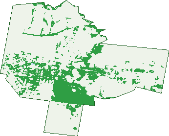
Green: 10 m cells where trees dominate, satellite 2021. Blue: water. The line is the suburb boundary.
| Canopy share, 1 m canopy height map, 2020 | 12.2% |
|---|---|
| Land with trees, 10 m satellite map, 2021 | 22.8% |
Demographics
Unemployment 2.3% · Labour-force participation 71.3%
Population by age in Batesford
| 0-4 | 51 |
|---|---|
| 5-14 | 221 |
| 15-19 | 109 |
| 20-24 | 68 |
| 25-34 | 59 |
| 35-44 | 158 |
| 45-54 | 197 |
| 55-64 | 149 |
| 65-74 | 89 |
| 75-84 | 41 |
| 85+ | 7 |
Dwelling types in Batesford
| House | 336 |
|---|---|
| Townhouse | 0 |
| Apartment | 3 |
| Other | 0 |
Households by weekly income in Batesford
| <$650 | 24 |
|---|---|
| $650-1,499 | 42 |
| $1,500-2,999 | 100 |
| $3,000+ | 143 |
Top ancestries in Batesford
| Australian | 476 |
|---|---|
| English | 409 |
| Irish | 169 |
| Scottish | 129 |
| Italian | 87 |
| Other | 78 |
Housing tenure in Batesford
| Owned | 133 |
|---|---|
| Mortgage | 184 |
| Rented | 9 |
| Other | 5 |
Cars per household in Batesford
| 0 | 0 |
|---|---|
| 1 | 24 |
| 2 | 146 |
| 3 | 78 |
| 4+ | 81 |
Commute to work in Batesford
| Car | 379 |
|---|---|
| Train | 0 |
| Bus | 0 |
| Tram/ferry | 0 |
| Walked | 12 |
| Bicycle | 0 |
| Home | 127 |
Top countries of birth in Batesford
| England | 27 |
|---|---|
| Italy | 11 |
| Poland | 8 |
| Croatia | 4 |
| Ireland | 3 |
| Netherlands | 3 |
Languages used at home in Batesford
| Italian | 12 |
|---|---|
| Croatian | 10 |
| Greek | 8 |
| Turkish | 6 |
| Macedonian | 4 |
| Arabic | 3 |
Birds & Wildlife Nearby
14,137 bird observations recorded near Batesford — most often seen:
- Red Wattlebird (804)
- Little Raven (766)
- New Holland Honeyeater (711)
- Superb Fairy-wren (684)
- Willie Wagtail (664)
- Magpie-lark (603)
- Common Starling (572)
- Australian Magpie (565)
- Rainbow Lorikeet (563)
- House Sparrow (541)
- Welcome Swallow (537)
- White-plumed Honeyeater (536)
- Red-rumped Parrot (520)
Show all 30 birds recorded near Batesford
- Eurasian Blackbird (490)
- Eastern Rosella (467)
- Southern Victoria Australian Magpie (463)
- Pacific Black Duck (447)
- Dusky Moorhen (407)
- Galah (386)
- Red-browed Finch (349)
- Grey Shrike-thrush (346)
- Common Myna (342)
- Grey Fantail (315)
- Crested Pigeon (310)
- Yellow-rumped Thornbill (310)
- European Goldfinch (303)
- Black-faced Cuckoo-shrike (297)
- Sulphur-crested Cockatoo (286)
- Spiny-cheeked Honeyeater (277)
- Brown Falcon (276)
Sightings reported by observers, not a survey, so the counts show what people record rather than what lives here. Source: Atlas of Living Australia.
Nearby Suburbs
The closest suburbs to Batesford:
- Moorabool (4.2 km)
- Gheringhap (4.4 km)
- Bell Post Hill (4.6 km)
- Lovely Banks (5 km)
- Bell Park (5.6 km)
- Hamlyn Heights (5.7 km)
- Stonehaven (5.8 km)
- Fyansford (6 km)
Embed this suburb
Add this free Batesford stat card to your own site — just copy the code:
Preview:
Cite this page
Quoting these figures? Copy the credit line:
Keep an eye on Batesford
One email when this data meaningfully changes — new census figures, prices, rankings. No spam, unsubscribe anytime.
Streets
- Ballan Road (7)
- Ballarat Road (108)
- Bates Court (3)
- Bilyana Road (35)
- Blackall Road (16)
- Bridge Street (8)
- Buchter Road (1)
- Chamount Court (6)
- Chaumont Court (6)
- Cobblestone Road (12)
- Cross Street (19)
- Cullinan Road (26)
- Daruma Way (20)
- Dinnys Lane (5)
- Dog Rocks Road (19)
- Domain Drive (27)
- Elmhurst Place (2)
- Fleurs Lane (12)
- Fyansford-gheringhap Road (2)
- Glenora Place (11)
- Granite Lane (6)
- Greenstone Lane (2)
- Hills Road (12)
- Honey Lane (8)
- Lynnburn Road (11)
- Madden Avenue (12)
- Margaret Way (12)
- Midland Highway (13)
- Millpond Lane (13)
- Old Ballarat Road (13)
- Old Midland Highway (5)
- Oxley Rise (15)
- Palmerston Street (4)
- Pennsylvania Avenue (13)
- Regent Street (2)
- River Street (7)
- Riverdance Road (6)
- Ross Road (4)
- Shepherd Road (34)
- Tarraford Way (36)
- Tolloora Way (29)
- Tulla Drive (1)
- Vigneron Avenue (16)
- Yorkshire Close (31)
- Yorkshire Close N (5)
- Yorkshire Close S (1)