Pooraka SA 5095
4,402 addresses · 155 streets
Makin Electorate › Salisbury LGA › Pooraka · 12 km from Adelaide
📦 Thinking of moving here? Read the Pooraka moving guide

Living Here
Pooraka is a suburb of South Australia, home to about 7,583 people, with a median age of 38. The typical household earns around $1,225 a week, with median rent near $300 a week. Most homes are houses. About 69% of households own their home and 30% rent. Most workers drive to work. Common community backgrounds include English, Australian, Vietnamese. On the ABS socio-economic scale it sits in decile 2 of 10 nationally — a more disadvantaged area. The median house sells for about $900,000.
Over time — Census 2001 → 2021
Dashed line: district figures for the Pooraka statistical area (SA2), the smallest area the ABS published before 2011. Solid line: Pooraka itself.
Getting Around & Local Services
5 supermarkets
2 pharmacies
3 doctors & medical clinics
3 physiotherapists
3 optometrists
2 childcare & kindergartens
1 butcher
2 hairdressers
2 beauty salons
2 electricians
Getting around. Train station: Greenfields, 3.1 km north · Bus interchange: Mawson Interchange, 2.7 km north-west · Airport: Adelaide Airport, 15.4 km south-west.
Socio-economic Standing
Deciles from 1 (lowest) to 10 (highest), against all Australian suburbs. The overall figure weighs advantage and disadvantage together; economic resources counts income and housing, and education & jobs counts qualifications and occupation. They often differ. Source: ABS SEIFA 2021.
Median Sale Prices
Median of recorded sales in the period, not a valuation. Source: Metropolitan Median House Sales, Valuer-General South Australia.
Tree cover
🌳 Tree canopy: 14% share of land under canopy · satellite map, 2020
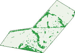
Green: 10 m cells where trees dominate, satellite 2021. Blue: water. The line is the suburb boundary.
| Canopy share, 1 m canopy height map, 2020 | 14.0% |
|---|---|
| Land with trees, 10 m satellite map, 2021 | 14.2% |
Demographics
Unemployment 7.5% · Labour-force participation 56.8%
Population by age in Pooraka
| 0-4 | 493 |
|---|---|
| 5-14 | 888 |
| 15-19 | 454 |
| 20-24 | 511 |
| 25-34 | 1,049 |
| 35-44 | 1,033 |
| 45-54 | 916 |
| 55-64 | 895 |
| 65-74 | 743 |
| 75-84 | 447 |
| 85+ | 152 |
Dwelling types in Pooraka
| House | 2,456 |
|---|---|
| Townhouse | 358 |
| Apartment | 44 |
| Other | 0 |
Households by weekly income in Pooraka
| <$650 | 608 |
|---|---|
| $650-1,499 | 988 |
| $1,500-2,999 | 834 |
| $3,000+ | 251 |
Top ancestries in Pooraka
| English | 1,899 |
|---|---|
| Australian | 1,801 |
| Other | 1,643 |
| Vietnamese | 647 |
| Italian | 429 |
| Indian | 393 |
Housing tenure in Pooraka
| Owned | 941 |
|---|---|
| Mortgage | 990 |
| Rented | 847 |
| Other | 40 |
Cars per household in Pooraka
| 0 | 208 |
|---|---|
| 1 | 1,108 |
| 2 | 967 |
| 3 | 343 |
| 4+ | 184 |
Commute to work in Pooraka
| Car | 2,449 |
|---|---|
| Train | 0 |
| Bus | 149 |
| Tram/ferry | 0 |
| Walked | 30 |
| Bicycle | 18 |
| Home | 189 |
Top countries of birth in Pooraka
| India | 486 |
|---|---|
| Vietnam | 452 |
| Afghanistan | 314 |
| England | 248 |
| Philippines | 141 |
| Pakistan | 89 |
Languages used at home in Pooraka
| Vietnamese | 676 |
|---|---|
| Punjabi | 309 |
| Arabic | 152 |
| Gujarati | 117 |
| Hindi | 103 |
| Italian | 85 |
Birds & Wildlife Nearby
57,317 bird observations recorded near Pooraka — most often seen:
- Australian White Ibis (3,055)
- Eurasian Coot (2,731)
- Pacific Black Duck (2,702)
- Dusky Moorhen (2,598)
- Grey Teal (2,470)
- Little Pied Cormorant (2,455)
- Chestnut Teal (2,259)
- Australian Pelican (2,225)
- Australasian Purple Swamphen (2,132)
- Magpie-lark (2,095)
- Little Black Cormorant (2,047)
- Black Swan (2,001)
- Common Starling (1,990)
Show all 30 birds recorded near Pooraka
- White-faced Heron (1,843)
- Welcome Swallow (1,817)
- Spotted Turtle-dove (1,776)
- House Sparrow (1,770)
- Eurasian Blackbird (1,623)
- Rock Dove (1,621)
- Crested Pigeon (1,617)
- Australasian Grebe (1,546)
- New Holland Honeyeater (1,545)
- Superb Fairy-wren (1,529)
- Rainbow Lorikeet (1,525)
- Willie Wagtail (1,469)
- Little Raven (1,432)
- Royal Spoonbill (1,381)
- Great Egret (1,358)
- Hoary-headed Grebe (1,354)
- Silver Gull (1,351)
Sightings reported by observers, not a survey, so the counts show what people record rather than what lives here. Source: Atlas of Living Australia.
Nearby Suburbs
The closest suburbs to Pooraka:
- Ingle Farm (1.9 km)
- Walkley Heights (2 km)
- Cavan (2.2 km)
- Mawson Lakes (2.3 km)
- Northfield (2.8 km)
- Gepps Cross (2.9 km)
- Northgate (3 km)
- Para Hills (3.2 km)
Embed this suburb
Add this free Pooraka stat card to your own site — just copy the code:
Preview:
Cite this page
Quoting these figures? Copy the credit line:
Keep an eye on Pooraka
One email when this data meaningfully changes — new census figures, prices, rankings. No spam, unsubscribe anytime.
Streets
- Abraham Street (30)
- Adaluma Avenue (26)
- Albert Street (46)
- Alfred Street (29)
- Almont Avenue (12)
- Ayr Street (3)
- Badcoe Street (44)
- Baker Terrace (12)
- Barakoola Street (29)
- Barli Street (24)
- Baroona Street (43)
- Baru Street (41)
- Batten Crescent (33)
- Binning Place (6)
- Booth Court (9)
- Borlace Court (12)
- Brady Court (10)
- Bramble Court (12)
- Bridge Road (101)
- Burma Road (25)
- Burns Avenue (23)
- Bushman Court (3)
- Carlyle Crescent (15)
- Carr Street (9)
- Casadio Court (22)
- Caston Street (15)
- Chant Place (5)
- Chellaston Avenue (36)
- Cherry Lane (8)
- Chester Crescent (14)
- Cleaver Avenue (17)
- Collins Court (16)
- Commerce Crescent (5)
- Coonong Avenue (18)
- Cowan Drive (33)
- Curbur Avenue (41)
- David Street (58)
- Davidson Court (28)
- Davies Place (10)
- Day Street (11)
- Desmond Avenue (36)
- Diagonal Road (96)
- Dobson Drive (34)
- Duffield Drive (32)
- Durali Street (1)
- Earle Court (12)
- Edwin Street (3)
- Elaine Avenue (12)
- Elder Avenue (38)
- Elva Avenue (8)
- Erlunga Court (11)
- Foster Street (6)
- Garnaut Avenue (12)
- George Street (17)
- Glover Avenue (25)
- Goldsborough Road (3)
- Hancock Avenue (9)
- Hanley Street (17)
- Hardy Court (7)
- Hazel Street (6)
- Henderson Avenue (99)
- Hillier Street (4)
- Hocking Crescent (11)
- Houston Terrace (27)
- Hughes Crescent (16)
- Hussey Terrace (22)
- Jay Street (10)
- Jean Street (63)
- Johnson Street (23)
- Kavanagh Court (18)
- Kindale Court (17)
- Kingsley Avenue (27)
- Lake Drive (22)
- Lana Street (3)
- Langford Street (80)
- Larsson Street (29)
- Lawrie Street (3)
- Levels Court (3)
- Lewis Court (14)
- Lincoln Crescent (40)
- Lindley Street (3)
- Lock Crescent (40)
- Lubcke Court (13)
- Lush Road (3)
- Lynch Court (13)
- Main North Road (156)
- Malkara Avenue (28)
- Manning Crescent (31)
- Market Lane (6)
- Marni Street (2)
- Maxwell Road (44)
- Mccarthy Court (17)
- Mcgowan Street (54)
- Meka Court (14)
- Mercedes Court (14)
- Merchant Crescent (8)
- Mintara Terrace (15)
- Mitchinson Grove (20)
- Montague Road (91)
- Muriel Drive (105)
- Musicka Avenue (32)
- Nalpa Street (30)
- Narrung Avenue (13)
- Noack Place (13)
- Norley Place (5)
- Page Court (12)
- Palmer Court (16)
- Paterson Road (16)
- Petunia Avenue (20)
- Pitts Court (11)
- Plane Court (13)
- Pratt Avenue (153)
- Priscilla Road (48)
- Produce Lane (13)
- Quigley Street (13)
- Quinlivan Road (98)
- Radomi Avenue (6)
- Radomi Close (3)
- Raffen Court (23)
- Rains Drive (26)
- Reagal Street (20)
- Regent Avenue (12)
- Research Road (197)
- Richard Avenue (28)
- Rissdon Grove (11)
- Rivett Place (10)
- Rocca Court (8)
- Rowland Road (11)
- Royal Avenue (228)
- Salzmann Drive (15)
- Sandow Avenue (28)
- Saxon Street (17)
- Scales Avenue (9)
- Schuit Crescent (27)
- Scott Street (95)
- Sophie Lane (43)
- South Terrace (141)
- Stanway Street (1)
- Steen Crescent (33)
- Tallering Avenue (29)
- Templar Crescent (33)
- Thelma Avenue (18)
- Tough Street (6)
- Trenton Terrace (44)
- Urawa Avenue (12)
- Van Leeuwen Drive (42)
- Wandina Avenue (24)
- Ween Road (40)
- Wheeler Avenue (39)
- Whit Street (3)
- Williams Circuit (22)
- Wilsen Terrace (17)
- Wooleen Avenue (26)
- Woolford Place (13)
- Yuin Court (9)