Highbury SA 5089
3,015 addresses · 137 streets
Sturt Electorate › Tea Tree Gully LGA › Highbury · 13 km from Adelaide
📦 Thinking of moving here? Read the Highbury moving guide

Living Here
Highbury is a suburb of South Australia, home to about 6,956 people, with a median age of 41. The typical household earns around $2,038 a week, with median rent near $369 a week. Most homes are houses. About 87% of households own their home and 12% rent. Most workers drive to work. Common community backgrounds include English, Australian, Italian. On the ABS socio-economic scale it sits in decile 9 of 10 nationally — a relatively advantaged area. The median house sells for about $1,185,000.
Over time — Census 2001 → 2021
Dashed line: district figures for the Highbury - Dernancourt statistical area (SA2), the smallest area the ABS published before 2011. Solid line: Highbury itself.
Getting Around & Local Services
6 supermarkets
4 doctors & medical clinics
2 dentists
2 physiotherapists
1 childcare centre
2 post offices
1 bakery
4 hardware stores
4 hairdressers
2 beauty salons
1 electrician
Getting around. Train station: Greenfields, 10 km north-west · Bus interchange: Tea Tree Plaza Interchange, 2.6 km north · Airport: Adelaide Airport, 18.5 km south-west.
Socio-economic Standing
Deciles from 1 (lowest) to 10 (highest), against all Australian suburbs. The overall figure weighs advantage and disadvantage together; economic resources counts income and housing, and education & jobs counts qualifications and occupation. They often differ. Source: ABS SEIFA 2021.
Median Sale Prices
Median of recorded sales in the period, not a valuation. Source: Metropolitan Median House Sales, Valuer-General South Australia.
Tree cover
🌳 Tree canopy: 25.3% share of land under canopy · satellite map, 2020
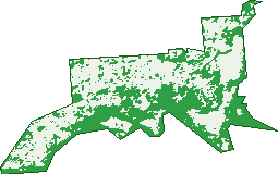
Green: 10 m cells where trees dominate, satellite 2021. Blue: water. The line is the suburb boundary.
| Canopy share, 1 m canopy height map, 2020 | 25.3% |
|---|---|
| Land with trees, 10 m satellite map, 2021 | 45.6% |
Demographics
Unemployment 4% · Labour-force participation 66.2%
Population by age in Highbury
| 0-4 | 370 |
|---|---|
| 5-14 | 877 |
| 15-19 | 481 |
| 20-24 | 409 |
| 25-34 | 736 |
| 35-44 | 876 |
| 45-54 | 979 |
| 55-64 | 866 |
| 65-74 | 819 |
| 75-84 | 447 |
| 85+ | 91 |
Dwelling types in Highbury
| House | 2,410 |
|---|---|
| Townhouse | 65 |
| Apartment | 0 |
| Other | 0 |
Households by weekly income in Highbury
| <$650 | 242 |
|---|---|
| $650-1,499 | 639 |
| $1,500-2,999 | 817 |
| $3,000+ | 663 |
Top ancestries in Highbury
| English | 2,568 |
|---|---|
| Australian | 2,208 |
| Italian | 1,037 |
| Other | 650 |
| German | 558 |
| Scottish | 538 |
Housing tenure in Highbury
| Owned | 1,032 |
|---|---|
| Mortgage | 1,114 |
| Rented | 300 |
| Other | 13 |
Cars per household in Highbury
| 0 | 47 |
|---|---|
| 1 | 614 |
| 2 | 1,126 |
| 3 | 425 |
| 4+ | 250 |
Commute to work in Highbury
| Car | 2,463 |
|---|---|
| Train | 0 |
| Bus | 175 |
| Tram/ferry | 0 |
| Walked | 17 |
| Bicycle | 19 |
| Home | 376 |
Top countries of birth in Highbury
| England | 360 |
|---|---|
| Italy | 155 |
| India | 115 |
| South Africa | 65 |
| China | 62 |
| Germany | 61 |
Languages used at home in Highbury
| Italian | 225 |
|---|---|
| Mandarin | 96 |
| Punjabi | 75 |
| Arabic | 69 |
| Polish | 52 |
| Afrikaans | 51 |
Birds & Wildlife Nearby
29,821 bird observations recorded near Highbury — most often seen:
- Rainbow Lorikeet (2,185)
- Australian Magpie (2,110)
- Noisy Miner (1,706)
- Red Wattlebird (1,541)
- Little Raven (1,373)
- Crimson Rosella (1,231)
- Galah (1,204)
- Australian Wood Duck (1,181)
- New Holland Honeyeater (1,170)
- Pacific Black Duck (1,124)
- Rock Dove (1,083)
- Magpie-lark (967)
- Dusky Moorhen (909)
Show all 30 birds recorded near Highbury
- Superb Fairy-wren (894)
- Eastern New Holland Honeyeater (883)
- Australian White Ibis (829)
- Spotted Turtle-dove (774)
- Australasian Purple Swamphen (759)
- Sulphur-crested Cockatoo (741)
- Grey Fantail (713)
- Eurasian Blackbird (708)
- Southern Magpie-lark (702)
- Crested Pigeon (659)
- Common Bronzewing (656)
- Eastern Rosella (644)
- Grey Currawong (640)
- Grey Shrike-thrush (613)
- Eastern Crested Pigeon (611)
- White-plumed Honeyeater (611)
- South Australian Superb Fairy-wren (600)
Sightings reported by observers, not a survey, so the counts show what people record rather than what lives here. Source: Atlas of Living Australia.
Nearby Suburbs
The closest suburbs to Highbury:
- Hope Valley (1.3 km)
- Athelstone (2 km)
- Dernancourt (2.6 km)
- Vista (2.7 km)
- Modbury (2.7 km)
- St Agnes (2.7 km)
- Holden Hill (3 km)
- Paradise (3.3 km)
Embed this suburb
Add this free Highbury stat card to your own site — just copy the code:
Preview:
Cite this page
Quoting these figures? Copy the credit line:
Keep an eye on Highbury
One email when this data meaningfully changes — new census figures, prices, rankings. No spam, unsubscribe anytime.
Streets
- Addolorata Court (25)
- Alister Street (18)
- Almerta Street (27)
- Amber Road (49)
- Andrea Street (23)
- Anson Avenue (5)
- Aqueduct Way (9)
- Ashby Avenue (1)
- Atlanta Court (6)
- Awoonga Road (25)
- Barns Avenue (53)
- Barracks Road (14)
- Beckman Avenue (63)
- Bell Court (10)
- Beurre Court (19)
- Blamey Court (8)
- Blue Wren Court (15)
- Boundy Road (18)
- Bradshaw Avenue (21)
- Brett Court (8)
- Bristol Crescent (30)
- Bruce Crescent (13)
- Buchanan Court (13)
- Casemate Street (12)
- Chauvel Court (10)
- Clarence Court (8)
- Colonial Court (9)
- Colton Avenue (15)
- Combe Place (1)
- Conifer Place (7)
- Country Lane (21)
- Crown Road (5)
- Cypress Court (3)
- Daryl Place (6)
- Declivity Street (47)
- Dene Road (52)
- Dinham Court (6)
- Domain Commons (28)
- Donald Street (25)
- Dordoy Street (8)
- Duncan Crescent (31)
- Dunn Road (31)
- Edmund Road (57)
- Elliston Avenue (31)
- Filippo Court (15)
- Freshford Avenue (8)
- Gail Court (5)
- Gallery Road (19)
- Garden Court (8)
- Garnet Court (14)
- Gaybas Court (4)
- Halls Road (10)
- Harold Street (33)
- Highbury Drive (46)
- Hillside Avenue (43)
- Historic Drive (46)
- Honeysuckle Drive (1)
- Inkster Road (2)
- Janet Court (16)
- Jet Court (6)
- Jones Court (5)
- Josephine Street (13)
- Kent Road (8)
- Kinnaird Crescent (19)
- Kismet Avenue (6)
- Konos Place (5)
- Lake View Crescent (88)
- Landscape Crescent (29)
- Lang Street (27)
- Larsen Court (12)
- Lavinia Grove (7)
- Lenbar Court (6)
- Leonard Street (14)
- Linden Road (17)
- Lindsay Street (20)
- Linear Park Drive (18)
- Lorraine Terrace (9)
- Lovelock Street (32)
- Lower North East Road (304)
- Macdonnell Street (40)
- Mahogany Avenue (24)
- Majestic Grove (24)
- Michigan Drive (15)
- Mitchell Avenue (45)
- Mitta Street (7)
- Monticle Street (32)
- Moon Crescent (5)
- Mulberry Drive (1)
- Nalga Court (5)
- Nentura Street (5)
- Niquet Avenue (18)
- Nobel Court (12)
- Nursery Way (25)
- Observation Drive (42)
- Old Sheoak Court (21)
- Olive Court (8)
- Packers Drive (41)
- Packham Place (13)
- Paradise Close (5)
- Paradise Grove (25)
- Park Valley Drive (27)
- Payne Street (2)
- Pecan Close (16)
- Peridot Close (12)
- Perrin Street (7)
- Pioneer Court (10)
- Radiata Road (19)
- Rayleigh Avenue (19)
- Reids Road (36)
- Rhus Road (6)
- Rogers Street (50)
- Rosewood Road (40)
- Rustic Court (12)
- Sapphire Crescent (42)
- Sassafras Drive (33)
- Silverlake Crescent (16)
- Stow Court (9)
- Sun Crescent (5)
- Teal Street (6)
- The Promenade (36)
- Torrens Road (8)
- Torrens View Court (9)
- Trafford Road (8)
- Urana Court (6)
- Valerie Avenue (10)
- Valley Road (49)
- Valley View Drive (106)
- Vasey Court (9)
- Vernons Drive (16)
- Walker Place (14)
- Wattlebird Drive (5)
- Wendy Court (6)
- Wicks Road (34)
- Windsor Road (12)
- Woodland Court (11)
- Xavier Street (67)
- Zircon Crescent (28)