Croydon Park SA 5008
2,360 addresses · 70 streets
Adelaide Electorate › Port Adelaide Enfield LGA › Croydon Park · 6 km from Adelaide
📦 Thinking of moving here? Read the Croydon Park moving guide

Living Here
Croydon Park is a suburb of South Australia, home to about 4,230 people, with a median age of 35. The typical household earns around $1,421 a week, with median rent near $320 a week. Most homes are houses. About 60% of households own their home and 39% rent. Most workers drive to work. Common community backgrounds include Australian, English, Vietnamese. On the ABS socio-economic scale it sits in decile 3 of 10 nationally — a more disadvantaged area. The median house sells for about $1,108,500.
Over time — Census 2001 → 2021
Dashed line: district figures for the The Parks statistical area (SA2), the smallest area the ABS published before 2011. Solid line: Croydon Park itself.
Getting Around & Local Services
34 schools
- St Margaret Mary's Catholic Church and School
- Adelaide Secondary School of English
- Challa Gardens Primary School
- Australian Islamic College (Adelaide)
- Whitefrair Catholic School
- Brompton Primary School
- Bowden Brompton Community School
- The Grove Education Centre
- Prospect Primary School
- Woodville Gardens School
3 physiotherapists
5 childcare & kindergartens
2 dog parks
2 beauty salons
Getting around. Train station: Islington, 1.5 km east · Tram stop: Entertainment Centre, 3.1 km south · Bus interchange: Klemzig Interchange, 6.6 km east · Airport: Adelaide Airport, 7.5 km south-west.
Socio-economic Standing
Deciles from 1 (lowest) to 10 (highest), against all Australian suburbs. The overall figure weighs advantage and disadvantage together; economic resources counts income and housing, and education & jobs counts qualifications and occupation. They often differ. Source: ABS SEIFA 2021.
Median Sale Prices
Median of recorded sales in the period, not a valuation. Source: Metropolitan Median House Sales, Valuer-General South Australia.
Tree cover
🌳 Tree canopy: 6.9% share of land under canopy · satellite map, 2020
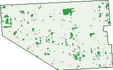
Green: 10 m cells where trees dominate, satellite 2021. Blue: water. The line is the suburb boundary.
| Canopy share, 1 m canopy height map, 2020 | 6.9% |
|---|---|
| Land with trees, 10 m satellite map, 2021 | 2.8% |
Demographics
Unemployment 6.9% · Labour-force participation 60.7%
Population by age in Croydon Park
| 0-4 | 270 |
|---|---|
| 5-14 | 408 |
| 15-19 | 196 |
| 20-24 | 328 |
| 25-34 | 869 |
| 35-44 | 598 |
| 45-54 | 460 |
| 55-64 | 420 |
| 65-74 | 367 |
| 75-84 | 166 |
| 85+ | 141 |
Dwelling types in Croydon Park
| House | 1,224 |
|---|---|
| Townhouse | 212 |
| Apartment | 89 |
| Other | 8 |
Households by weekly income in Croydon Park
| <$650 | 312 |
|---|---|
| $650-1,499 | 461 |
| $1,500-2,999 | 468 |
| $3,000+ | 216 |
Top ancestries in Croydon Park
| Other | 911 |
|---|---|
| Australian | 693 |
| English | 670 |
| Vietnamese | 640 |
| Greek | 343 |
| Italian | 301 |
Housing tenure in Croydon Park
| Owned | 447 |
|---|---|
| Mortgage | 458 |
| Rented | 583 |
| Other | 21 |
Cars per household in Croydon Park
| 0 | 151 |
|---|---|
| 1 | 536 |
| 2 | 537 |
| 3 | 182 |
| 4+ | 110 |
Commute to work in Croydon Park
| Car | 1,417 |
|---|---|
| Train | 4 |
| Bus | 97 |
| Tram/ferry | 3 |
| Walked | 20 |
| Bicycle | 21 |
| Home | 144 |
Top countries of birth in Croydon Park
| Vietnam | 471 |
|---|---|
| India | 318 |
| Greece | 142 |
| Philippines | 88 |
| Cambodia | 68 |
| England | 68 |
Languages used at home in Croydon Park
| Vietnamese | 656 |
|---|---|
| Greek | 281 |
| Punjabi | 178 |
| Italian | 91 |
| Arabic | 80 |
| Mandarin | 72 |
Birds & Wildlife Nearby
46,795 bird observations recorded near Croydon Park — most often seen:
- Noisy Miner (3,210)
- Australian Magpie (2,712)
- Rock Dove (2,486)
- Southern Magpie-lark (1,980)
- Eastern Crested Pigeon (1,964)
- Rainbow Lorikeet (1,951)
- Galah (1,861)
- White-plumed Honeyeater (1,823)
- Spotted Turtle-dove (1,819)
- Eastern Welcome Swallow (1,791)
- Australian Wood Duck (1,774)
- Musk Lorikeet (1,636)
- Southern Willie Wagtail (1,563)
Show all 30 birds recorded near Croydon Park
- Little Raven (1,448)
- Giinbaywarraymal (1,447)
- Australasian Purple Swamphen (1,405)
- Little Black Cormorant (1,398)
- Eastern Rainbow Lorikeet (1,382)
- Magpie-lark (1,380)
- Pacific Black Duck (1,287)
- European Common Starling (1,278)
- South-east Eastern Rosella (1,169)
- Black Swan (1,164)
- Dusky Moorhen (1,152)
- Western Striated Pardalote (1,025)
- Australian Pelican (969)
- Eurasian Coot (944)
- Little Pied Cormorant (934)
- Masked Lapwing (930)
- Crested Pigeon (913)
Sightings reported by observers, not a survey, so the counts show what people record rather than what lives here. Source: Atlas of Living Australia.
Nearby Suburbs
The closest suburbs to Croydon Park:
- Dudley Park (1 km)
- West Croydon (1.2 km)
- Kilkenny (1.3 km)
- Renown Park (1.4 km)
- Devon Park (1.4 km)
- Ferryden Park (1.4 km)
- Croydon (1.6 km)
- Ridleyton (1.6 km)
Embed this suburb
Add this free Croydon Park stat card to your own site — just copy the code:
Preview:
Cite this page
Quoting these figures? Copy the credit line:
Keep an eye on Croydon Park
One email when this data meaningfully changes — new census figures, prices, rankings. No spam, unsubscribe anytime.
Streets
- Alvis Road (33)
- Auburn Crescent (40)
- Austin Street (33)
- Bentley Avenue (14)
- Berleit Road (3)
- Berliet Street (4)
- Bieg Street (22)
- Boomerang Road (80)
- Charron Road (48)
- Chrysler Road (36)
- Citroen Street (1)
- Collins Street (15)
- Cooper Avenue (12)
- Cowley Avenue (6)
- Crossley Avenue (64)
- Days Road (187)
- Durant Road (17)
- Eldon Street (24)
- Ena Street (47)
- Essex Crescent (23)
- Flanders Street (18)
- Garson Avenue (22)
- Goodall Avenue (41)
- Gray Street (3)
- Hardy Street (61)
- Harley Road (28)
- Harrison Road (4)
- Hefford Avenue (38)
- Hotchkiss Crescent (42)
- Hudson Avenue (49)
- Itala Avenue (12)
- James Street (20)
- Lamont Street (49)
- Lancia Road (47)
- Laurel Avenue (14)
- Liberton Avenue (25)
- Little Street (23)
- Margitich Street (29)
- Mccarron Way (37)
- Mercedes Avenue (13)
- Mersey Street (1)
- Minerva Crescent (40)
- Morlei Avenue (20)
- Morris Street (23)
- Nash Street (23)
- Nyonga Avenue (57)
- Oswald Street (31)
- Overland Road (92)
- Packard Avenue (23)
- Pym Street (56)
- Rainsford Avenue (18)
- Regency Road (83)
- Reo Road (38)
- Rickaby Street (52)
- Ross Avenue (15)
- Rover Avenue (16)
- Royce Avenue (17)
- Rugby Avenue (24)
- Shirley Avenue (23)
- South Road (94)
- Standard Avenue (33)
- Star Avenue (1)
- Stevens Street (37)
- Sunbeam Road (43)
- Talbot Road (46)
- Torinda Avenue (4)
- Torrens Road (82)
- Tungara Avenue (58)
- Vauxhall Street (17)
- Wolseley Road (9)