Craigburn Farm SA 5051
1,318 addresses · 66 streets
Mayo Electorate › Mitcham LGA › Craigburn Farm · 12 km from Adelaide
📦 Thinking of moving here? Read the Craigburn Farm moving guide

Living Here
Craigburn Farm is a suburb of South Australia, home to about 3,099 people, with a median age of 41. The typical household earns around $2,944 a week, with median rent near $550 a week. Most homes are houses. About 93% of households own their home and 6% rent. Most workers drive to work. Common community backgrounds include English, Australian, Scottish. On the ABS socio-economic scale it sits in decile 10 of 10 nationally — a relatively advantaged area. The median house sells for about $1,452,500.
Over time — Census 2001 → 2021
Dashed line: district figures for the Blackwood statistical area (SA2), the smallest area the ABS published before 2011. Solid line: Craigburn Farm itself.
Getting Around & Local Services
5 supermarkets
2 doctors & medical clinics
2 dentists
1 physiotherapist
2 optometrists
4 childcare & kindergartens
3 post offices
3 service stations
1 gym
2 butchers
2 hardware stores
2 mechanics
2 electricians
4 plumbers
Getting around. Train station: Coromandel, 1.5 km north · Bus interchange: Blackwood Interchange, 2.1 km north · Airport: Adelaide Airport, 13 km north-west.
Socio-economic Standing
Deciles from 1 (lowest) to 10 (highest), against all Australian suburbs. The overall figure weighs advantage and disadvantage together; economic resources counts income and housing, and education & jobs counts qualifications and occupation. They often differ. Source: ABS SEIFA 2021.
Median Sale Prices
Median of recorded sales in the period, not a valuation. Source: Metropolitan Median House Sales, Valuer-General South Australia.
Tree cover
🌳 Tree canopy: 34.3% share of land under canopy · satellite map, 2020
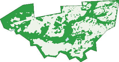
Green: 10 m cells where trees dominate, satellite 2021. Blue: water. The line is the suburb boundary.
| Canopy share, 1 m canopy height map, 2020 | 34.3% |
|---|---|
| Land with trees, 10 m satellite map, 2021 | 47.7% |
Demographics
Unemployment 2.9% · Labour-force participation 68.8%
Population by age in Craigburn Farm
| 0-4 | 162 |
|---|---|
| 5-14 | 467 |
| 15-19 | 226 |
| 20-24 | 154 |
| 25-34 | 230 |
| 35-44 | 478 |
| 45-54 | 498 |
| 55-64 | 403 |
| 65-74 | 321 |
| 75-84 | 138 |
| 85+ | 28 |
Dwelling types in Craigburn Farm
| House | 1,014 |
|---|---|
| Townhouse | 4 |
| Apartment | 0 |
| Other | 0 |
Households by weekly income in Craigburn Farm
| <$650 | 50 |
|---|---|
| $650-1,499 | 155 |
| $1,500-2,999 | 274 |
| $3,000+ | 475 |
Top ancestries in Craigburn Farm
| English | 1,401 |
|---|---|
| Australian | 1,002 |
| Other | 305 |
| Scottish | 304 |
| Irish | 243 |
| German | 226 |
Housing tenure in Craigburn Farm
| Owned | 384 |
|---|---|
| Mortgage | 570 |
| Rented | 61 |
| Other | 8 |
Cars per household in Craigburn Farm
| 0 | 3 |
|---|---|
| 1 | 190 |
| 2 | 543 |
| 3 | 176 |
| 4+ | 107 |
Commute to work in Craigburn Farm
| Car | 1,082 |
|---|---|
| Train | 40 |
| Bus | 17 |
| Tram/ferry | 0 |
| Walked | 4 |
| Bicycle | 0 |
| Home | 257 |
Top countries of birth in Craigburn Farm
| England | 287 |
|---|---|
| South Africa | 66 |
| China | 52 |
| India | 52 |
| Scotland | 35 |
| Malaysia | 26 |
Languages used at home in Craigburn Farm
| Mandarin | 68 |
|---|---|
| Afrikaans | 43 |
| Greek | 28 |
| Hindi | 28 |
| Cantonese | 18 |
| Persian | 16 |
Birds & Wildlife Nearby
52,782 bird observations recorded near Craigburn Farm — most often seen:
- Rainbow Lorikeet (4,577)
- Australian Magpie (3,975)
- Little Raven (3,390)
- Noisy Miner (2,786)
- Red Wattlebird (2,681)
- Galah (2,374)
- Eastern Rosella (2,099)
- Crimson Rosella (2,001)
- Crested Pigeon (1,774)
- New Holland Honeyeater (1,664)
- Eurasian Blackbird (1,628)
- Laughing Kookaburra (1,619)
- Sulphur-crested Cockatoo (1,582)
Show all 30 birds recorded near Craigburn Farm
- Australian Wood Duck (1,536)
- Eyre Peninsula Australian Magpie (1,442)
- Superb Fairy-wren (1,391)
- Striated Pardalote (1,374)
- Pacific Black Duck (1,359)
- Magpie-lark (1,350)
- Fleurieu Adelaide Rosella (1,342)
- Western Red Wattlebird (1,267)
- Common Bronzewing (1,216)
- Grey Currawong (1,216)
- Western Striated Pardalote (1,143)
- Dusky Moorhen (1,125)
- South Australian Superb Fairy-wren (1,027)
- Eurasian Coot (974)
- Grey Fantail (968)
- Silvereye (961)
- Eastern New Holland Honeyeater (941)
Sightings reported by observers, not a survey, so the counts show what people record rather than what lives here. Source: Atlas of Living Australia.
Nearby Suburbs
The closest suburbs to Craigburn Farm:
- Coromandel Valley (1.1 km)
- Blackwood (2.1 km)
- Eden Hills (2.4 km)
- Flagstaff Hill (2.6 km)
- Hawthorndene (2.6 km)
- Bellevue Heights (2.7 km)
- Glenalta (3.4 km)
- Aberfoyle Park (3.6 km)
Embed this suburb
Add this free Craigburn Farm stat card to your own site — just copy the code:
Preview:
Cite this page
Quoting these figures? Copy the credit line:
Keep an eye on Craigburn Farm
One email when this data meaningfully changes — new census figures, prices, rankings. No spam, unsubscribe anytime.
Streets
- Alexandra Place (9)
- Appleberry Crescent (21)
- Arnold Crescent (26)
- Austin Court (9)
- Blackwood Park Boulevard (92)
- Bluebell Court (18)
- Bonython Way (42)
- Bright Place (10)
- Brookman Crescent (29)
- Carraway Court (4)
- Champion Way (21)
- Cochrane Street (4)
- Coromandel Parade (16)
- Cottage Court (8)
- Craigburn Farm Circuit (34)
- Craigburn Road (27)
- Creswell Avenue (37)
- Cumming Street (22)
- Dairy Court (9)
- Dawbiney Avenue (25)
- Diosma Drive (1)
- Dorothy Lane (11)
- Dunsford Street (12)
- Earls Court (18)
- Fergusson Avenue (64)
- Fisher Crescent (37)
- Gartrell Boulevard (38)
- Goode Avenue (17)
- Grand Boulevard (40)
- Grass Lily Street (6)
- Grenache Circuit (34)
- Hackett Close (6)
- Harvey Close (5)
- Hayman Retreat (23)
- Highfield Drive (82)
- Holly Hock Court (21)
- Hughes Court (12)
- Isla Way (14)
- Kaufmann Place (3)
- Laslett Court (14)
- Malbec Street (12)
- Maslin Street (17)
- Newland Court (12)
- Richman Court (18)
- Riding Way (21)
- Rogerson Circuit (28)
- Shelter Row (35)
- Shiraz Court (3)
- Star Lily Street (16)
- Sun Dew Avenue (15)
- Symon Crescent (50)
- Tassie Place (11)
- The Farm Lane (10)
- Tokay Court (6)
- Verco Place (7)
- Verdelho Street (15)
- Warriparinga Avenue (22)
- Waterhouse Court (8)
- Wattlewood Court (4)
- Watts Terrace (10)
- William Rufus Place (6)
- William Scott Circuit (22)
- Win Gilchrist Avenue (11)
- Woodlake Drive (15)
- Woods View (15)
- Wren Court (8)