Aldinga Beach SA 5173
6,104 addresses · 196 streets
Mayo Electorate › Onkaparinga LGA › Aldinga Beach · 41 km from Adelaide
📦 Thinking of moving here? Read the Aldinga Beach moving guide

Living Here
Aldinga Beach is a suburb of South Australia, home to about 10,667 people, with a median age of 39. The typical household earns around $1,297 a week, with median rent near $320 a week. Most homes are houses. About 70% of households own their home and 28% rent. Most workers drive to work. Common community backgrounds include English, Australian, Scottish. On the ABS socio-economic scale it sits in decile 2 of 10 nationally — a more disadvantaged area. The median house sells for about $840,000.
Over time — Census 2001 → 2021
Dashed line: district figures for the Aldinga statistical area (SA2), the smallest area the ABS published before 2011. Solid line: Aldinga Beach itself.
Getting Around & Local Services
4 cafés & restaurants
2 doctors & medical clinics
2 libraries
1 post office
1 service station
1 gym
1 golf club
1 bakery
1 hardware store
1 mechanic
1 place to stay
Getting around. Airport: Adelaide Airport, 38.3 km north.
Socio-economic Standing
Deciles from 1 (lowest) to 10 (highest), against all Australian suburbs. The overall figure weighs advantage and disadvantage together; economic resources counts income and housing, and education & jobs counts qualifications and occupation. They often differ. Source: ABS SEIFA 2021.
Median Sale Prices
Median of recorded sales in the period, not a valuation. Source: Metropolitan Median House Sales, Valuer-General South Australia.
Tree cover
🌳 Tree canopy: 19.3% share of land under canopy · satellite map, 2020
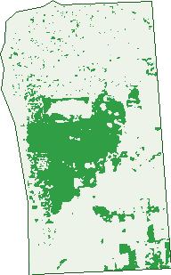
Green: 10 m cells where trees dominate, satellite 2021. Blue: water. The line is the suburb boundary.
| Canopy share, 1 m canopy height map, 2020 | 19.3% |
|---|---|
| Land with trees, 10 m satellite map, 2021 | 23.3% |
Demographics
Unemployment 6.1% · Labour-force participation 59.3%
Population by age in Aldinga Beach
| 0-4 | 609 |
|---|---|
| 5-14 | 1,613 |
| 15-19 | 681 |
| 20-24 | 568 |
| 25-34 | 1,193 |
| 35-44 | 1,446 |
| 45-54 | 1,334 |
| 55-64 | 1,271 |
| 65-74 | 1,106 |
| 75-84 | 625 |
| 85+ | 215 |
Dwelling types in Aldinga Beach
| House | 3,683 |
|---|---|
| Townhouse | 313 |
| Apartment | 16 |
| Other | 24 |
Households by weekly income in Aldinga Beach
| <$650 | 738 |
|---|---|
| $650-1,499 | 1,405 |
| $1,500-2,999 | 1,184 |
| $3,000+ | 404 |
Top ancestries in Aldinga Beach
| English | 5,547 |
|---|---|
| Australian | 4,030 |
| Scottish | 1,151 |
| Irish | 914 |
| German | 732 |
| Other | 558 |
Housing tenure in Aldinga Beach
| Owned | 1,057 |
|---|---|
| Mortgage | 1,720 |
| Rented | 1,116 |
| Other | 99 |
Cars per household in Aldinga Beach
| 0 | 139 |
|---|---|
| 1 | 1,499 |
| 2 | 1,593 |
| 3 | 507 |
| 4+ | 262 |
Commute to work in Aldinga Beach
| Car | 3,285 |
|---|---|
| Train | 40 |
| Bus | 32 |
| Tram/ferry | 6 |
| Walked | 70 |
| Bicycle | 20 |
| Home | 440 |
Top countries of birth in Aldinga Beach
| England | 1,141 |
|---|---|
| New Zealand | 141 |
| Scotland | 132 |
| South Africa | 79 |
| Netherlands | 62 |
| Germany | 57 |
Languages used at home in Aldinga Beach
| German | 48 |
|---|---|
| Italian | 40 |
| Spanish | 30 |
| Mandarin | 25 |
| Afrikaans | 23 |
| Greek | 23 |
Birds & Wildlife Nearby
30,209 bird observations recorded near Aldinga Beach — most often seen:
- Little Raven (1,896)
- Common Starling (1,674)
- White-faced Heron (1,396)
- Pacific Black Duck (1,304)
- Little Pied Cormorant (1,295)
- Australian Magpie (1,246)
- Red Wattlebird (1,135)
- Superb Fairy-wren (1,072)
- Eyre Peninsula Australian Magpie (1,043)
- Grey Teal (1,020)
- House Sparrow (1,020)
- New Holland Honeyeater (957)
- Southern Magpie-lark (941)
Show all 30 birds recorded near Aldinga Beach
- Rainbow Lorikeet (913)
- Crested Pigeon (892)
- Magpie-lark (876)
- Western Red Wattlebird (861)
- Australasian Purple Swamphen (860)
- Galah (857)
- Rock Dove (857)
- Eastern Welcome Swallow (848)
- Australian White Ibis (836)
- Mistletoebird (836)
- Eurasian Blackbird (827)
- White-plumed Honeyeater (818)
- Eastern Crested Pigeon (808)
- Eastern New Holland Honeyeater (798)
- Eurasian Coot (788)
- Silvereye (787)
- Welcome Swallow (748)
Sightings reported by observers, not a survey, so the counts show what people record rather than what lives here. Source: Atlas of Living Australia.
Nearby Suburbs
The closest suburbs to Aldinga Beach:
- Port Willunga (1.9 km)
- Aldinga (2.8 km)
- Sellicks Hill (4.9 km)
- Sellicks Beach (5.5 km)
- Whites Valley (5.9 km)
- Maslin Beach (6.1 km)
- Tatachilla (7 km)
- Moana (8.3 km)
Embed this suburb
Add this free Aldinga Beach stat card to your own site — just copy the code:
Preview:
Cite this page
Quoting these figures? Copy the credit line:
Keep an eye on Aldinga Beach
One email when this data meaningfully changes — new census figures, prices, rankings. No spam, unsubscribe anytime.
Streets
- Acacia Terrace (41)
- Addison Street (26)
- Aldam Avenue (59)
- Aldinga Beach Road (224)
- Aquamarine Avenue (41)
- Atkinson Crescent (45)
- Attunga Road (6)
- Azure Place (4)
- Banksia Avenue (27)
- Barracoota Crescent (33)
- Barramundi Way (22)
- Basin Street (49)
- Batts Street (3)
- Battye Street (2)
- Bayside Avenue (32)
- Berry Street (12)
- Bird Street (2)
- Birdsong Street (9)
- Blacker Road (58)
- Blue Bay Avenue (29)
- Bluepoint Way (32)
- Boomerang Avenue (14)
- Brighton Place (11)
- Bristol Street (65)
- Burton Bank (13)
- Bushtail Avenue (43)
- Butterworth Road (128)
- Button Road (12)
- Cameron Road (66)
- Cancun Parkway (12)
- Casuarina Avenue (23)
- Central Way (1)
- Chartreuse Court (11)
- Chenoweth Street (4)
- Clift Street (5)
- Coast Lane (4)
- Cobalt Place (20)
- Cockle Avenue (28)
- Coolangatta Drive (69)
- Corry Court (13)
- Cove Street (19)
- Cowrie Road (11)
- Cox Road (19)
- Crisp Street (3)
- Croser Avenue (66)
- Culley Street (6)
- Cuttle Street (20)
- Darwalla Road (29)
- Dingo Road (15)
- Dolphin Boulevard (40)
- Dover Lane (5)
- Dover Street (96)
- Dunstan Street (31)
- Emerald Boulevard (222)
- Esplanade (402)
- Evans Street (13)
- Evergreen Court (24)
- Fidge Street (5)
- Follett Street (55)
- Fraser Street (9)
- Garden Street (2)
- Glen Street (7)
- Gordon Street (74)
- Goshawk Walk (7)
- Greenlees Parade (53)
- Grosvenor Road (31)
- Hack Street (12)
- Halcyon Circuit (47)
- Hamilton Road (65)
- Harbour Street (8)
- Harvey Crescent (69)
- Heathersay Avenue (27)
- Helen Avenue (28)
- How Road (60)
- Humphrys Road (27)
- Illman Crescent (43)
- Indigo Court (29)
- Irving Road (51)
- Jade Loop (42)
- Jobson Street (11)
- John Street (9)
- Justs Road (12)
- Kaurna Avenue (26)
- Kestrel Terrace (39)
- Ketch Court (27)
- Kimber Street (71)
- Kipsy Lane (7)
- Kipsy Street (64)
- Kipsy Walk (1)
- Kirra Road (6)
- Kitto Crescent (30)
- Knoll Avenue (18)
- Kuta Crescent (31)
- Kuta Place (6)
- Lacey Drive (24)
- Lacy Coral Avenue (19)
- Lagoon Circuit (30)
- Leaker Avenue (25)
- Lichen Walk (6)
- Loongana Road (3)
- Lovelock Street (22)
- Magpie Road (4)
- Main South Road (9)
- Martin Crescent (23)
- Maurice Street (18)
- Mcburney Crescent (26)
- Mcdonald Avenue (37)
- Mckenzie Street (19)
- Mcrae Street (2)
- Meadow Bank Way (31)
- Mistletoe Street (10)
- Moore Street (4)
- Morgan Street (18)
- Moss Court (39)
- Myerhoff Street (12)
- Nardoo Road (13)
- Neva Street (3)
- Nicholl Avenue (74)
- Ningana Road (51)
- Norman Road (38)
- Oakley Crescent (51)
- Ocean Street (18)
- Ochre Drive (32)
- Offshore Avenue (17)
- Palmer Street (40)
- Panorama Way (8)
- Parrot Road (7)
- Pebble Court (21)
- Pengilly Road (8)
- Periwinkle Drive (13)
- Pinkgum Avenue (23)
- Plymouth Street (38)
- Pointon Street (25)
- Polden Street (16)
- Polkinghorn Avenue (14)
- Polkinghorn Court (3)
- Pridham Boulevard (237)
- Quail Street (15)
- Quinliven Road (89)
- Quondong Avenue (11)
- Rainbird Court (23)
- Ratcliffe Road (52)
- Razor Avenue (3)
- Redgum Avenue (12)
- Reed Street (7)
- Rowley Road (191)
- Ryan Avenue (17)
- Sapphire Way (43)
- Scrub Avenue (15)
- Scrub Court (2)
- Seagreen Way (8)
- Seagull Street (17)
- Seahaven Way (44)
- Seahorse Way (7)
- Seaview Street (34)
- Sedge Street (12)
- Sheoak Avenue (6)
- Shephard Road (26)
- Sienna Court (15)
- Sims Road (6)
- Spinnaker Court (20)
- Standfield Road (42)
- Starfish Drive (32)
- Stark Street (7)
- Stewart Avenue (9)
- Stirling Crescent (56)
- Stock Street (16)
- Stone Street (2)
- Storey Avenue (67)
- Strout Street (3)
- Sunday Boulevard (30)
- Sunday Lane (1)
- Sunset Parade (31)
- Symonds Street (38)
- Tangerine Court (27)
- Teal Close (12)
- Thomas Street (22)
- Throw Street (4)
- Tidewater Street (17)
- Toucan Loop (18)
- Treasure Street (14)
- Trenerry Street (21)
- Turquoise Court (34)
- Urchin Crescent (16)
- Venice Avenue (13)
- Vine Way (14)
- Walsh Street (18)
- Warrigal Road (39)
- Wattle Avenue (6)
- Whinnerah Avenue (95)
- Whistlers Avenue (34)
- White Court (15)
- Whitehaven Circuit (44)
- Wigham Road (47)
- Wild Orchid Avenue (21)
- Wurlie Road (5)