Thornlands QLD 4164
8,793 addresses · 321 streets
Bowman Electorate › Redland LGA › Thornlands · 26 km from Brisbane
📦 Thinking of moving here? Read the Thornlands moving guide

Living Here
A family suburb in the Redlands south-east of Brisbane, Thornlands is built around newer homes on larger blocks. Households average 2.9 people and the median age is 36. Median household income is $2,218 a week, with rent around $470.
Thornlands is a suburb of Queensland, home to about 19,263 people, with a median age of 36. The typical household earns around $2,218 a week, with median rent near $470 a week. Most homes are houses. About 72% of households own their home and 26% rent. Most workers drive to work. Common community backgrounds include English, Australian, Scottish. On the ABS socio-economic scale it sits in decile 9 of 10 nationally — a relatively advantaged area.
Over time — Census 2001 → 2021
Dashed line: district figures for the Thornlands statistical area (SA2), the smallest area the ABS published before 2011. Solid line: Thornlands itself.
Getting Around & Local Services
3 Catholic churches
2 pharmacies
2 physiotherapists
1 optometrist
2 hospitals
1 post office
6 service stations
1 dog park
1 butcher
2 hardware stores
1 beauty salon
3 mechanics
1 carpenter
Getting around. Train station: Cleveland, 4.3 km north · Bus interchange: Victoria Point Central, 3.1 km south-east · Ferry wharf: Cleveland (Toondah Harbour) Passenger Ferry, 4.2 km north-east · Airport: Dunwich Airport, 16.7 km east.
Socio-economic Standing
Deciles from 1 (lowest) to 10 (highest), against all Australian suburbs. The overall figure weighs advantage and disadvantage together; economic resources counts income and housing, and education & jobs counts qualifications and occupation. They often differ. Source: ABS SEIFA 2021.
Tree cover
🌳 Tree canopy: 28.6% share of land under canopy · satellite map, 2020
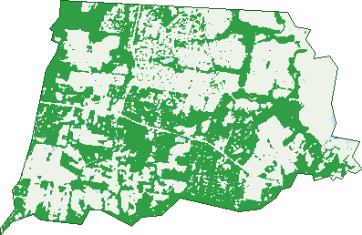
Green: 10 m cells where trees dominate, satellite 2021. Blue: water. The line is the suburb boundary.
| Canopy share, 1 m canopy height map, 2020 | 28.6% |
|---|---|
| Land with trees, 10 m satellite map, 2021 | 49.2% |
Demographics
Unemployment 3.7% · Labour-force participation 70.3%
Population by age in Thornlands
| 0-4 | 1,240 |
|---|---|
| 5-14 | 2,895 |
| 15-19 | 1,440 |
| 20-24 | 1,233 |
| 25-34 | 2,321 |
| 35-44 | 2,625 |
| 45-54 | 2,658 |
| 55-64 | 2,165 |
| 65-74 | 1,564 |
| 75-84 | 809 |
| 85+ | 324 |
Dwelling types in Thornlands
| House | 5,593 |
|---|---|
| Townhouse | 743 |
| Apartment | 63 |
| Other | 3 |
Households by weekly income in Thornlands
| <$650 | 601 |
|---|---|
| $650-1,499 | 1,309 |
| $1,500-2,999 | 2,209 |
| $3,000+ | 1,873 |
Top ancestries in Thornlands
| English | 8,644 |
|---|---|
| Australian | 6,904 |
| Scottish | 2,335 |
| Irish | 2,066 |
| Other | 1,699 |
| German | 1,080 |
Housing tenure in Thornlands
| Owned | 1,576 |
|---|---|
| Mortgage | 2,982 |
| Rented | 1,660 |
| Other | 123 |
Cars per household in Thornlands
| 0 | 137 |
|---|---|
| 1 | 1,483 |
| 2 | 2,954 |
| 3 | 1,118 |
| 4+ | 658 |
Commute to work in Thornlands
| Car | 6,928 |
|---|---|
| Train | 66 |
| Bus | 71 |
| Tram/ferry | 4 |
| Walked | 67 |
| Bicycle | 16 |
| Home | 1,564 |
Top countries of birth in Thornlands
| England | 1,405 |
|---|---|
| New Zealand | 989 |
| South Africa | 487 |
| India | 215 |
| Scotland | 172 |
| Philippines | 167 |
Languages used at home in Thornlands
| Afrikaans | 178 |
|---|---|
| Punjabi | 166 |
| Mandarin | 113 |
| Spanish | 86 |
| Tagalog | 78 |
| German | 63 |
Birds & Wildlife Nearby
47,715 bird observations recorded near Thornlands — most often seen:
- Rainbow Lorikeet (2,875)
- Noisy Miner (2,761)
- Australian White Ibis (2,741)
- Torresian Crow (2,454)
- Australian Magpie (2,175)
- Laughing Kookaburra (1,818)
- Welcome Swallow (1,802)
- Magpie-lark (1,726)
- Pied Butcherbird (1,667)
- Willie Wagtail (1,625)
- Brown Honeyeater (1,600)
- Pacific Black Duck (1,593)
- Masked Lapwing (1,592)
Show all 30 birds recorded near Thornlands
- Grey Butcherbird (1,586)
- Lewin's Honeyeater (1,422)
- Crested Pigeon (1,354)
- Grey Shrike-thrush (1,340)
- Rufous Whistler (1,320)
- Dusky Moorhen (1,283)
- Noisy Friarbird (1,256)
- Australasian Figbird (1,246)
- Grey Fantail (1,223)
- Black-faced Cuckoo-shrike (1,217)
- Striated Pardalote (1,207)
- Australian Wood Duck (1,199)
- White-faced Heron (1,165)
- Little Pied Cormorant (1,140)
- Spotted Turtle-dove (1,138)
- Bar-shouldered Dove (1,095)
- Scaly-breasted Lorikeet (1,095)
Sightings reported by observers, not a survey, so the counts show what people record rather than what lives here. Source: Atlas of Living Australia.
Nearby Suburbs
The closest suburbs to Thornlands:
- Cleveland (3.5 km)
- Victoria Point (3.9 km)
- Alexandra Hills (5.6 km)
- Ormiston (5.6 km)
- Sheldon (6.4 km)
- Coochiemudlo Island (6.6 km)
- Capalaba (7.2 km)
- Wellington Point (7.8 km)
Embed this suburb
Add this free Thornlands stat card to your own site — just copy the code:
Preview:
Cite this page
Quoting these figures? Copy the credit line:
Keep an eye on Thornlands
One email when this data meaningfully changes — new census figures, prices, rankings. No spam, unsubscribe anytime.
Streets
- Abalone Crescent (48)
- Abbotsleigh Street (42)
- Abeya Street (7)
- Abraham Street (13)
- Acacia Street (29)
- Achernar Court (23)
- Affinity Way (33)
- Ajinby Close (6)
- Albicore Drive (41)
- Allary Street (2)
- Andreas Close (11)
- Angliss Circuit (28)
- Anisila Road (8)
- Apex Street (41)
- Apple Gum Crescent (18)
- Arctic Street (40)
- Arkwright Street (24)
- Balfour Place (8)
- Barramul Place (40)
- Barrique Court (20)
- Bay Breeze Avenue (18)
- Bay Crest Place (14)
- Baythorn Drive (17)
- Beaujolais Street (3)
- Beddoe Street (23)
- Berkingham Street (22)
- Beutel Place (19)
- Beveridge Road (69)
- Blue Water Avenue (44)
- Bluebird Court (8)
- Bokhara Street (19)
- Bonnie Street (2)
- Bonnyton Street (11)
- Boundary Road (287)
- Braidwood Street (13)
- Breckenridge Court (6)
- Brindabella Circuit (49)
- Buenavista Avenue (28)
- Burgundy Crescent (19)
- Burrum Street (59)
- Bush Cherry Place (18)
- Butternut Circuit (40)
- Buxton Court (3)
- Bygraves Street (15)
- Cabernet Crescent (45)
- Caldwell Close (11)
- Calliandra Place (21)
- Callum Court (12)
- Cardwell Circuit (48)
- Carlingford Drive (42)
- Carmay Close (8)
- Casasola Place (8)
- Cecilia Close (13)
- Chablis Court (7)
- Champagne Crescent (28)
- Chardonnay Court (27)
- Chateau Street (38)
- Cimmaron Circuit (22)
- Claret Court (8)
- Clayton Court (20)
- Cleveland Redland Bay Road (136)
- Cleveland-redland Bay Road (96)
- Clifford Perske Drive (30)
- Cockateil Court (16)
- Coen Street (20)
- Colishua Court (4)
- Colthouse Drive (27)
- Condamine Crescent (18)
- Congreve Crescent (30)
- Conley Avenue (21)
- Connie Way (1)
- Constantina Close (13)
- Coralbay Close (8)
- Dalwood Court (5)
- Dasen Street (2)
- Daughtrey Street (12)
- Davenport Street (19)
- Dawn Crescent (35)
- Dicameron Court (16)
- Dinwoodie Road (86)
- Doull Place (4)
- Drysdale Close (12)
- Dune Street (11)
- Dylan Street (7)
- East Ridge Street (26)
- Eastview Crescent (34)
- Edina Street (103)
- Eileen Close (10)
- Elderberry Street (17)
- Eprapah Road (3)
- Eridani Court (19)
- Falcon Avenue (13)
- Ferdinando Close (8)
- Flamingo Crescent (51)
- Freshwater Street (153)
- Gaylen Street (25)
- George Thorn Drive (45)
- Georgina Court (4)
- Ghost Gum Close (12)
- Glencoe Street (6)
- Glendevon Street (57)
- Glenys Street (7)
- Goddard Road (41)
- Godfrey Street (19)
- Golliker Street (10)
- Grandview Court (8)
- Gretchen Circuit (41)
- Gunadoo Street (19)
- Hannah Close (4)
- Harrington Boulevard (69)
- Hawk Parade (9)
- Hawkins Place (19)
- Hayes Street (2)
- Heather Street (12)
- Hermitage Crescent (45)
- Herring Lane (2)
- Hideaway Court (8)
- Highfield Avenue (34)
- Highgreen Place (18)
- Highgrove Street (112)
- Hock Street (4)
- Honeyeater Court (13)
- Hopgood Close (5)
- Houghton Close (13)
- Ingot Close (8)
- Inkerman Place (20)
- Island Outlook Avenue (68)
- Isle View Street (3)
- Jackwood Street (8)
- Jarvis Court (3)
- Jaydee Court (15)
- Jeff Street (3)
- Jenmar Court (10)
- Jerrys Place (34)
- Jessie Close (9)
- Jewel Place (8)
- Jicama Court (13)
- Joanne Crescent (30)
- Jonbar Court (17)
- Judanne Court (16)
- Kalbarrie Terrace (37)
- Karragarra Place (15)
- Katie Place (4)
- Kerder Street (36)
- Kiama Circuit (36)
- Kidman Circuit (28)
- Kim Jon Court (29)
- King Street (357)
- Kingsdale Avenue (108)
- Kinross Road (113)
- Kirkgate Street (12)
- Kite Crescent (20)
- Kodak Close (25)
- Korsman Drive (23)
- Kriskyle Place (2)
- Lake View Drive (34)
- Lathro Way (28)
- Laurette Avenue (26)
- Leven Street (27)
- Lewis Street (9)
- Lexia Court (6)
- Lidgard Street (18)
- Lind Street (12)
- Linkview Place (10)
- Lochridge Street (58)
- Lorikeet Drive (36)
- Lotus Close (6)
- Luke Street (81)
- Lungren Drive (38)
- Lyndhurst Place (17)
- Macleay Place (24)
- Madeira Court (5)
- Maged Place (16)
- Majella Court (4)
- Majestic Circuit (55)
- Mango Place (7)
- Manhattan Avenue (16)
- Manning Esplanade (50)
- Maranoa Street (17)
- Marcoola Street (42)
- Margery Street (43)
- Marjoram Street (19)
- Mataro Court (8)
- Mcbride Circuit (106)
- Mcpherson Street (21)
- Meadowland Road (1)
- Megan Court (18)
- Melanie Street (8)
- Melville Street (15)
- Merlot Place (5)
- Milner Place (21)
- Monterey Avenue (40)
- Moreton Road (2)
- Moreton Road N (10)
- Moreton Road S (8)
- Moreton View Crescent (37)
- Morris Circuit (116)
- Moselle Drive (67)
- Moyston Court (12)
- Muirfield Street (14)
- Nadine Crescent (15)
- Nato Court (7)
- Newburgh Street (31)
- Newport Place (12)
- Noir Court (11)
- Nook Court (5)
- Oak Leaf Street (8)
- Osprey Drive (39)
- Pannikin Place (16)
- Panorama Drive (156)
- Park Street (16)
- Pateman Parade (113)
- Peachface Court (6)
- Petrel Court (16)
- Pheasant Court (9)
- Pinecone Place (19)
- Platres Drive (10)
- Plover Drive (19)
- Pontiac Street (28)
- Poppy Street (17)
- Portias Place (31)
- Primrose Drive (54)
- Rachel Place (18)
- Rachow Street (155)
- Radiance Crescent (34)
- Ransom Court (13)
- Rauburn Street (32)
- Redbill Close (9)
- Redland Bay Road (143)
- Reef Street (22)
- Ribonwood Street (45)
- Richmond Close (9)
- Riesling Street (72)
- Rise Court (5)
- River Gum Close (11)
- Rosemary Street (19)
- Round Shop Road (26)
- Rowe Crescent (36)
- Sable Close (13)
- Sam Place (19)
- Sandalwood Street (41)
- Sandune Place (14)
- Santagiuliana Parade (21)
- Sauterne Street (11)
- Sauvignon Court (15)
- Sea Spray Street (12)
- Seaforth Avenue (10)
- Seahorse Court (3)
- Seaspray Street (12)
- Seawater Street (20)
- Semillon Street (25)
- Sequoia Street (10)
- Shane Court (5)
- Shiraz Street (13)
- Shirley Street (3)
- Shoalwater Street (17)
- Skilton Place (20)
- South Street (80)
- Spatlese Court (15)
- Springacre Road (34)
- Springwater Street (25)
- Stanton Street (24)
- Starfish Court (3)
- Stringybark Court (6)
- Summer Bay Drive (4)
- Sunsail Place (19)
- Sunview Street (20)
- Sutherland Street (19)
- Swallow Street (15)
- Sylvie Street (28)
- Tahoe Court (12)
- Tamarind Close (13)
- Tane Court (5)
- Taylor Road (22)
- The Grove (6)
- Thornlands Road (126)
- Thornton Drive (19)
- Tide Place (11)
- Tindappah Drive (17)
- Tindappah Drive S (39)
- Tokay Court (10)
- Toorak Close (13)
- Touriga Street (25)
- Traminer Court (11)
- Trevally Court (10)
- Trochus Court (17)
- Trout Street (28)
- Trundle Road (19)
- Truscot Place (15)
- Tuckeroo Street (3)
- Tudar Place (31)
- Tuna Court (5)
- Vega Court (6)
- Venn Parade (36)
- Verdelho Street (26)
- Viewland Crescent (38)
- Vintage Drive (42)
- Walter Drive (47)
- Water Gum Place (14)
- Waterline Boulevard (47)