Wellington Point QLD 4160
5,904 addresses · 224 streets
Bowman Electorate › Redland LGA › Wellington Point · 21 km from Brisbane
📦 Thinking of moving here? Read the Wellington Point moving guide

Living Here
Wellington Point is a suburb of Queensland, home to about 12,661 people, with a median age of 43. The typical household earns around $2,197 a week, with median rent near $450 a week. Most homes are houses. About 80% of households own their home and 20% rent. Most workers drive to work. Common community backgrounds include English, Australian, Irish. On the ABS socio-economic scale it sits in decile 9 of 10 nationally — a relatively advantaged area.
Over time — Census 2001 → 2021
Dashed line: district figures for the Wellington Point statistical area (SA2), the smallest area the ABS published before 2011. Solid line: Wellington Point itself.
Getting Around & Local Services
4 supermarkets
2 doctors & medical clinics
4 physiotherapists
2 hospitals
2 childcare & kindergartens
2 libraries
2 butchers
2 beauty salons
1 plumber
1 carpenter
3 places to stay
Getting around. Train station: Wellington Point, 500 m north-east · Bus interchange: Capalaba bus station, 5.4 km south-west · Ferry wharf: Cleveland (Toondah Harbour), 5.7 km south-east · Airport: Brisbane Airport, 17.3 km north-west.
Socio-economic Standing
Deciles from 1 (lowest) to 10 (highest), against all Australian suburbs. The overall figure weighs advantage and disadvantage together; economic resources counts income and housing, and education & jobs counts qualifications and occupation. They often differ. Source: ABS SEIFA 2021.
Tree cover
🌳 Tree canopy: 22.1% share of land under canopy · satellite map, 2020
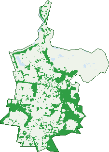
Green: 10 m cells where trees dominate, satellite 2021. Blue: water. The line is the suburb boundary.
| Canopy share, 1 m canopy height map, 2020 | 22.1% |
|---|---|
| Land with trees, 10 m satellite map, 2021 | 27.7% |
Demographics
Unemployment 3.9% · Labour-force participation 67.1%
Population by age in Wellington Point
| 0-4 | 555 |
|---|---|
| 5-14 | 1,752 |
| 15-19 | 1,002 |
| 20-24 | 652 |
| 25-34 | 1,029 |
| 35-44 | 1,562 |
| 45-54 | 1,976 |
| 55-64 | 1,895 |
| 65-74 | 1,360 |
| 75-84 | 660 |
| 85+ | 216 |
Dwelling types in Wellington Point
| House | 3,951 |
|---|---|
| Townhouse | 283 |
| Apartment | 191 |
| Other | 0 |
Households by weekly income in Wellington Point
| <$650 | 476 |
|---|---|
| $650-1,499 | 968 |
| $1,500-2,999 | 1,323 |
| $3,000+ | 1,417 |
Top ancestries in Wellington Point
| English | 5,862 |
|---|---|
| Australian | 4,400 |
| Irish | 1,715 |
| Scottish | 1,656 |
| Other | 978 |
| German | 723 |
Housing tenure in Wellington Point
| Owned | 1,578 |
|---|---|
| Mortgage | 1,920 |
| Rented | 886 |
| Other | 16 |
Cars per household in Wellington Point
| 0 | 107 |
|---|---|
| 1 | 1,219 |
| 2 | 1,915 |
| 3 | 741 |
| 4+ | 426 |
Commute to work in Wellington Point
| Car | 4,166 |
|---|---|
| Train | 156 |
| Bus | 32 |
| Tram/ferry | 7 |
| Walked | 59 |
| Bicycle | 24 |
| Home | 1,242 |
Top countries of birth in Wellington Point
| England | 950 |
|---|---|
| New Zealand | 621 |
| South Africa | 317 |
| Scotland | 115 |
| Ireland | 67 |
| India | 62 |
Languages used at home in Wellington Point
| Mandarin | 86 |
|---|---|
| Afrikaans | 84 |
| Italian | 41 |
| Spanish | 33 |
| Russian | 32 |
| German | 30 |
Birds & Wildlife Nearby
56,683 bird observations recorded near Wellington Point — most often seen:
- Australian White Ibis (3,462)
- Rainbow Lorikeet (3,055)
- Noisy Miner (3,009)
- Torresian Crow (2,999)
- Welcome Swallow (2,763)
- Australian Magpie (2,346)
- Masked Lapwing (2,320)
- Australian Pied Oystercatcher (2,023)
- Eastern Curlew (2,008)
- Bar-tailed Godwit (2,006)
- Magpie-lark (1,946)
- Red-necked Stint (1,924)
- Silver Gull (1,895)
Show all 30 birds recorded near Wellington Point
- Whimbrel (1,857)
- White-faced Heron (1,787)
- Little Pied Cormorant (1,682)
- Grey Butcherbird (1,598)
- Mangrove Honeyeater (1,564)
- Caspian Tern (1,492)
- Laughing Kookaburra (1,472)
- Red-capped Plover (1,466)
- Pied Butcherbird (1,460)
- Little Egret (1,439)
- Brown Honeyeater (1,431)
- Willie Wagtail (1,419)
- Grey-tailed Tattler (1,300)
- Australasian Figbird (1,296)
- Black-faced Cuckoo-shrike (1,269)
- Great Knot (1,233)
- Curlew Sandpiper (1,162)
Sightings reported by observers, not a survey, so the counts show what people record rather than what lives here. Source: Atlas of Living Australia.
Nearby Suburbs
The closest suburbs to Wellington Point:
- Birkdale (2.2 km)
- Ormiston (2.5 km)
- Alexandra Hills (3.6 km)
- Thorneside (3.7 km)
- Cleveland (4.9 km)
- Capalaba (5.6 km)
- Ransome (5.8 km)
- Lota (6 km)
Embed this suburb
Add this free Wellington Point stat card to your own site — just copy the code:
Preview:
Cite this page
Quoting these figures? Copy the credit line:
Keep an eye on Wellington Point
One email when this data meaningfully changes — new census figures, prices, rankings. No spam, unsubscribe anytime.
Streets
- Aaron Court (7)
- Acacia Street (6)
- Alford Place (16)
- Alice Street (35)
- Allan Day Drive (66)
- Allenby Road (92)
- Aminta Court (3)
- Angelo Street (3)
- Anhs Place (11)
- Anson Road (13)
- Apsley Street (25)
- Arbor Terrace (19)
- Archer Place (18)
- Arthur Street (27)
- Arwon Court (12)
- Ashley Court (23)
- Atrium Close (6)
- Aureo Court (14)
- Badgen Road (1)
- Bahr Place (12)
- Balmoral Street (1)
- Banyan Circuit (27)
- Barkala Street (6)
- Bayfields Avenue (4)
- Bayview Street (59)
- Beachcrest Road (70)
- Beard Place (6)
- Beldale Court (14)
- Belford Drive (62)
- Bella Street (2)
- Bellbird Street (4)
- Bellevista Crescent (20)
- Bertson Crescent (10)
- Bethnal Court (11)
- Bibury Street (24)
- Birkdale Road (73)
- Biscay Street (10)
- Bligh Street (1)
- Breezeway Close (6)
- Buckland Street (44)
- Burgess Court (12)
- Burnett Street (29)
- Burwana Place (18)
- Canary Street (8)
- Canegrove Circuit (33)
- Carlyle Court (10)
- Casey Court (7)
- Cashmere Court (11)
- Cedarview Place (15)
- Celsa Street (20)
- Champion Lane (12)
- Charles Canty Drive (124)
- Chermside Street (52)
- Cherry Street (34)
- Chesterfield Crescent (35)
- Christina Street (35)
- Ciril Court (8)
- Collingwood Road (1)
- Comic Court (11)
- Cooinda Street (15)
- Corey Close (12)
- Courtice Street (1)
- Coventry Court (18)
- Cronin Drive (20)
- Crossley Drive (33)
- Dalrello Drive (34)
- Dalston Street (23)
- Daphne Street (1)
- Day Court (10)
- Deanna Court (7)
- Discovery Place (15)
- Douro Road (61)
- Drake Street (19)
- Duke Street (11)
- Duncan Street (78)
- Eastcote Lane (5)
- Eastern Court (11)
- Edie Terrace (19)
- Edith Street (60)
- Emma Court (9)
- Esplanade (19)
- Ethel Street (13)
- Euston Court (7)
- Evelyn Court (6)
- Farnham Street (24)
- Felix Court (6)
- Fernbourne Road (47)
- Folkestone Court (13)
- Forsyth Place (6)
- Frederick Street (64)
- Fulbeck Place (16)
- Galena Street (22)
- Genevieve Court (15)
- Gilchrist Street (17)
- Goodall Street (25)
- Goose Street (7)
- Grenaid Court (12)
- Grosvenor Court (19)
- Gull Street (2)
- Gunsynd Court (13)
- Gwingarra Street (11)
- Hardy Road (21)
- Harris Street (93)
- Helena Street (31)
- Herbert Road (5)
- Heritage Drive (18)
- Hillcrest Street (13)
- Hilliards Park Drive (75)
- Hodges Close (8)
- Horton Place (5)
- Hoskins Drive (28)
- Hurst Close (5)
- Isobell Court (12)
- Jacob Street (31)
- Janelle Court (32)
- Jasper Street (27)
- Jellicoe Street (40)
- Joyce Court (12)
- Kane Court (8)
- Kefford Street (16)
- Kelso Street (29)
- Kerby Place (12)
- Kerridge Court (13)
- Kerry Close (14)
- King Island Drive (28)
- Kingsway Street (9)
- Lang Street (7)
- Laurance Court (23)
- Leah Court (9)
- Leonard Street (15)
- Lido Court (8)
- Lincoln Close (2)
- Liner Street (18)
- Lords Street (15)
- Main Road (759)
- Mander Court (11)
- Mann Place (6)
- Manor Drive (31)
- Marcel Place (21)
- Maria Court (7)
- Marlborough Road (67)
- Marshall Lane (10)
- Masson Court (10)
- Matilda Street (22)
- Mcdonald Road (9)
- Mcnab Close (10)
- Mindarie Crescent (63)
- Montgomery Drive (44)
- Mornington Court (16)
- Mossip Court (10)
- Musgrave Street (34)
- Nelson Road (15)
- Noel Street (5)
- North Haven Place (13)
- Nursery Street (7)
- O'connell Parade (36)
- Oceanic Street (22)
- Old Cleveland Road (1)
- Old Cleveland Road E (138)
- Owen Street (12)
- Paige Court (25)
- Parkview Avenue (7)
- Parnka Street (8)
- Paulina Street (23)
- Peewee Court (7)
- Pembury Court (9)
- Penguin Street (11)
- Peprose Place (11)
- Peters Court (10)
- Peterson Street (87)
- Pitt Road (3)
- Plantation Place (20)
- Plumer Street (59)
- Poloni Place (41)
- Prunda Circuit (50)
- Queensbury Court (28)
- Raife Close (10)
- Rankin Street (16)
- Redgrove Avenue (44)
- Reserve Esplanade (2)
- Riverton Drive (41)
- Roberts Street (31)
- Ronald Court (10)
- Rosedale Court (9)
- Rosella Street (43)
- Rye Street (23)
- Sandpiper Street (41)
- Saranah Place (11)
- Schonrock Street (32)
- Sheena Street (33)
- Skinner Avenue (35)
- Sophie Court (8)
- Sorrento Close (10)
- Spink Street (3)
- Spurs Drive (115)
- Starkey Street (68)
- Station Street (99)
- Stuart Street (4)
- Sturgeon Street (1)
- Sylvania Street (33)
- Tanya Court (7)
- Tarvin Close (13)
- Tern Court (8)
- Thrush Court (3)
- Tiffany Court (9)
- Trafalgar Vale Avenue (55)
- Tulloch Drive (52)
- Turner Crescent (29)
- Valley Road (77)
- Vantage Crescent (33)
- Veitch Close (10)
- Wagan Place (13)
- Wallace Street (20)
- Walton Way (12)
- Warlow Close (10)
- Warner Street (78)
- Waterloo Street (9)
- Wedd Close (8)
- Wellesley Street (61)
- Westmill Close (9)
- Wharton Street (6)
- Whepstead Avenue (18)
- Willard Close (12)
- Wogan Court (6)