Mount Coot-tha QLD 4066
88 addresses · 13 streets
Ryan Electorate › Brisbane LGA › Mount Coot-tha · 6 km from Brisbane

Getting Around & Local Services
3 supermarkets
1 pharmacy
8 service stations
4 hardware stores
4 beauty salons
Getting around. Train station: Taringa, 3 km south-east · Bus interchange: The Gap park 'n' ride, 4.3 km north-west · Ferry wharf: Regatta ferry terminal, 3.8 km east · Airport: Brisbane Airport, 19 km north-east.
Tree cover
🌳 Tree canopy: 94.2% share of land under canopy · satellite map, 2020
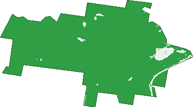
Green: 10 m cells where trees dominate, satellite 2021. Blue: water. The line is the suburb boundary.
| Canopy share, 1 m canopy height map, 2020 | 94.2% |
|---|---|
| Land with trees, 10 m satellite map, 2021 | 97.2% |
Birds & Wildlife Nearby
88,544 bird observations recorded near Mount Coot-tha — most often seen:
- Noisy Miner (7,265)
- Rainbow Lorikeet (6,361)
- Torresian Crow (6,138)
- Sulphur-crested Cockatoo (5,546)
- Pied Currawong (4,526)
- Australian Brush-turkey (4,477)
- Australian Magpie (3,991)
- Laughing Kookaburra (3,705)
- Welcome Swallow (3,467)
- Grey Butcherbird (3,446)
- Pied Butcherbird (3,375)
- Scaly-breasted Lorikeet (3,341)
- Blue-faced Honeyeater (2,733)
Show all 30 birds recorded near Mount Coot-tha
- Australian White Ibis (2,624)
- Australasian Figbird (2,573)
- Magpie-lark (2,391)
- Lewin's Honeyeater (2,003)
- Dusky Moorhen (1,869)
- Pacific Black Duck (1,862)
- Masked Lapwing (1,719)
- Noisy Friarbird (1,713)
- Australian King-parrot (1,689)
- Striated Pardalote (1,643)
- Pale-headed Rosella (1,535)
- Bush Stone-curlew (1,508)
- Eastern Whipbird (1,486)
- Crested Pigeon (1,424)
- Olive-backed Oriole (1,386)
- Australian Wood Duck (1,384)
- Galah (1,364)
Sightings reported by observers, not a survey, so the counts show what people record rather than what lives here. Source: Atlas of Living Australia.
Nearby Suburbs
The closest suburbs to Mount Coot-tha:
- Bardon (2.5 km)
- Toowong (3 km)
- Chapel Hill (3.1 km)
- Taringa (3.1 km)
- Indooroopilly (3.5 km)
- Auchenflower (3.5 km)
- The Gap (3.6 km)
- Paddington (4 km)
Embed this suburb
Add this free Mount Coot-tha stat card to your own site — just copy the code:
Preview:
Cite this page
Quoting these figures? Copy the credit line:
Keep an eye on Mount Coot-tha
One email when this data meaningfully changes — new census figures, prices, rankings. No spam, unsubscribe anytime.
Streets
- Boscombe Road (1)
- Broseley Road (1)
- Chapel Hill Road (2)
- Crag Road (1)
- Gap Creek Road (5)
- Moggill Road (1)
- Mount Coot Tha Road (7)
- Mount Coot-tha Road (7)
- Oxford Road (1)
- Sir Samuel Griffith Drive (58)
- Taringa Parade (1)
- Whitehead Road (2)
- Wool Street (1)