Toowong QLD 4066
9,576 addresses · 136 streets
Ryan Electorate › Brisbane LGA › Toowong · 4 km from Brisbane
📦 Thinking of moving here? Read the Toowong moving guide

Living Here
An inner-western Brisbane suburb near the university with a riverside setting, Toowong is young and apartment-rich. Households average 2.1 people and the median age is 30. Median household income is $1,927 a week, with rent around $420.
Toowong is a suburb of Queensland, home to about 12,556 people, with a median age of 30. The typical household earns around $1,927 a week, with median rent near $420 a week. Most homes are apartments. About 44% of households own their home and 55% rent. Most workers drive to work. Common community backgrounds include English, Australian, Irish. On the ABS socio-economic scale it sits in decile 10 of 10 nationally — a relatively advantaged area.
Over time — Census 2001 → 2021
Dashed line: district figures for the Toowong statistical area (SA2), the smallest area the ABS published before 2011. Solid line: Toowong itself.
Getting Around & Local Services
29 childcare & kindergartens
9 service stations
Getting around. Train station: Toowong, 450 m south-east · Bus interchange: UQ Chancellors's Place, 2.7 km south-east · Ferry wharf: Regatta ferry terminal, 750 m east · Airport: Brisbane Airport, 17.5 km north-east.
Socio-economic Standing
Deciles from 1 (lowest) to 10 (highest), against all Australian suburbs. The overall figure weighs advantage and disadvantage together; economic resources counts income and housing, and education & jobs counts qualifications and occupation. They often differ. Source: ABS SEIFA 2021.
Tree cover
🌳 Tree canopy: 27.2% share of land under canopy · satellite map, 2020
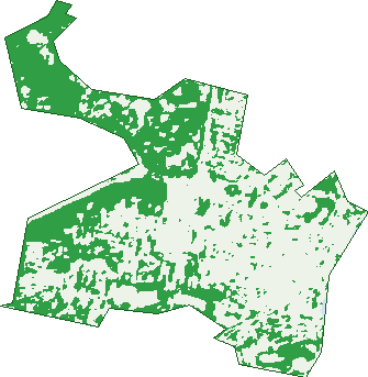
Green: 10 m cells where trees dominate, satellite 2021. Blue: water. The line is the suburb boundary.
| Canopy share, 1 m canopy height map, 2020 | 27.2% |
|---|---|
| Land with trees, 10 m satellite map, 2021 | 40.9% |
Demographics
Unemployment 5.5% · Labour-force participation 71.1%
Population by age in Toowong
| 0-4 | 498 |
|---|---|
| 5-14 | 1,006 |
| 15-19 | 812 |
| 20-24 | 2,036 |
| 25-34 | 2,962 |
| 35-44 | 1,710 |
| 45-54 | 1,260 |
| 55-64 | 970 |
| 65-74 | 766 |
| 75-84 | 417 |
| 85+ | 120 |
Dwelling types in Toowong
| House | 1,529 |
|---|---|
| Townhouse | 135 |
| Apartment | 3,642 |
| Other | 0 |
Households by weekly income in Toowong
| <$650 | 696 |
|---|---|
| $650-1,499 | 1,233 |
| $1,500-2,999 | 1,729 |
| $3,000+ | 1,399 |
Top ancestries in Toowong
| English | 4,241 |
|---|---|
| Australian | 3,425 |
| Other | 1,822 |
| Irish | 1,816 |
| Scottish | 1,469 |
| Chinese | 1,448 |
Housing tenure in Toowong
| Owned | 1,126 |
|---|---|
| Mortgage | 1,196 |
| Rented | 2,939 |
| Other | 70 |
Cars per household in Toowong
| 0 | 671 |
|---|---|
| 1 | 2,705 |
| 2 | 1,486 |
| 3 | 327 |
| 4+ | 135 |
Commute to work in Toowong
| Car | 2,860 |
|---|---|
| Train | 421 |
| Bus | 301 |
| Tram/ferry | 54 |
| Walked | 344 |
| Bicycle | 209 |
| Home | 1,947 |
Top countries of birth in Toowong
| China | 765 |
|---|---|
| England | 441 |
| New Zealand | 317 |
| India | 239 |
| South Africa | 165 |
| Malaysia | 141 |
Languages used at home in Toowong
| Mandarin | 935 |
|---|---|
| Spanish | 279 |
| Cantonese | 219 |
| Hindi | 90 |
| Japanese | 81 |
| Korean | 81 |
Birds & Wildlife Nearby
255,050 bird observations recorded near Toowong — most often seen:
- Noisy Miner (21,338)
- Torresian Crow (18,653)
- Rainbow Lorikeet (16,643)
- Australian White Ibis (14,368)
- Welcome Swallow (12,960)
- Pied Currawong (11,590)
- Australian Magpie (11,296)
- Grey Butcherbird (10,470)
- Australian Brush-turkey (9,959)
- Pied Butcherbird (9,742)
- Scaly-breasted Lorikeet (9,275)
- Magpie-lark (9,203)
- Australasian Figbird (9,047)
Show all 30 birds recorded near Toowong
- Sulphur-crested Cockatoo (7,552)
- Laughing Kookaburra (7,195)
- Dusky Moorhen (6,968)
- Blue-faced Honeyeater (6,377)
- Masked Lapwing (6,292)
- Australian Wood Duck (6,018)
- Bush Stone-curlew (5,609)
- Pacific Black Duck (5,245)
- Rock Dove (5,163)
- Little Corella (4,748)
- Willie Wagtail (4,748)
- Australasian Darter (4,588)
- Crested Pigeon (4,569)
- Spotted Turtle-dove (4,210)
- Little Black Cormorant (3,928)
- Tree Martin (3,670)
- Common Myna (3,626)
Sightings reported by observers, not a survey, so the counts show what people record rather than what lives here. Source: Atlas of Living Australia.
Nearby Suburbs
The closest suburbs to Toowong:
- Auchenflower (1.2 km)
- Taringa (1.3 km)
- West End (1.6 km)
- St Lucia (1.9 km)
- Milton (2.2 km)
- Indooroopilly (2.5 km)
- Paddington (2.7 km)
- Bardon (2.7 km)
Embed this suburb
Add this free Toowong stat card to your own site — just copy the code:
Preview:
Cite this page
Quoting these figures? Copy the credit line:
Keep an eye on Toowong
One email when this data meaningfully changes — new census figures, prices, rankings. No spam, unsubscribe anytime.
Streets
- Ada Street (19)
- Annerley Street (9)
- Archer Street (380)
- Ascog Terrace (214)
- Ashton Street (1)
- Aston Street (44)
- Augustus Street (263)
- Ballara Lane (5)
- Bates Lane (2)
- Bayliss Street (122)
- Bennett Street (47)
- Benson Street (276)
- Bent Street (56)
- Birdwood Terrace (100)
- Booth Street (10)
- Brisbane Street (109)
- Brixton Street (6)
- Broseley Road (74)
- Burns Road (24)
- Bywong Street (43)
- Cadell Street (170)
- Camp Street (44)
- Campbell Street (144)
- Clayton Lane (2)
- Clouston Lane (1)
- Coram Lane (3)
- Coronation Drive (377)
- Cross Street (6)
- Croydon Street (64)
- Curlew Street (32)
- Dacre Street (15)
- Dampier Street (1)
- Darley Street (13)
- Dean Street (63)
- Delungra Street (17)
- Dempster Street (37)
- Depper Street (22)
- Devon Street (10)
- Dixon Street (1)
- Dovercourt Road (68)
- Duke Street (50)
- Earle Lane (117)
- Ebor Street (2)
- Eldridge Street (25)
- Elizabeth Street (187)
- Emerson Street (26)
- Eskmount Drive (2)
- Eton Street (25)
- Exmouth Street (19)
- Explorer Street (53)
- Fewings Street (36)
- Frederick Street (45)
- Gailey Road (19)
- Gilrey Street (8)
- Glen Road (132)
- Glenny Street (16)
- Golding Street (39)
- Gower Street (46)
- Gregory Street (26)
- Grove Crescent (19)
- Grove Street (106)
- Herbert Street (21)
- Heroes Avenue (1)
- High Street (437)
- Holland Street (124)
- Holmes Street (46)
- Horrocks Street (13)
- Hunter Street (1)
- Indooroopilly Road (4)
- Ivy Street (21)
- Jephson Street (483)
- Josling Street (38)
- Kapunda Street (29)
- Kate Street (12)
- Kensington Terrace (64)
- Kent Street (24)
- Kerr Street (26)
- Land Street (464)
- Landsborough Terrace (77)
- Lissner Street (321)
- Little Maryvale Street (13)
- Lodge Street (23)
- Macdonnell Street (57)
- Maraket Street (13)
- Market Street (11)
- Maryvale Street (372)
- Mayne Street (19)
- Mcgrath Street (10)
- Milton Road (115)
- Miskin Street (238)
- Moggill Road (3)
- Morley Street (69)
- Mount Coot Tha Road (9)
- Mount Coot-tha Road (12)
- Mount Street (41)
- Musgrave Street (29)
- Norwood Street (88)
- Okeden Street (28)
- Old Mount Coot Tha Road (26)
- Old Mount Coot-tha Road (26)
- Orchard Street (41)
- Oxford Road (4)
- Paisley Street (12)
- Park Lane (1)
- Patrick Lane (165)
- Penrose Street (2)
- Pictavia Street (16)
- Pioneer Street (46)
- Purkiss Street (18)
- Quinn Street (98)
- Richer Street (18)
- Rose Terrace (6)
- Saint Osyth Street (42)
- Sherwood Road (690)
- Siemon Street (21)
- Sir Samuel Griffith Drive (6)
- Sleath Street (27)
- Soudan Street (32)
- Standring Street (6)
- Sussex Street (30)
- Sylvan Road (576)
- Terrace Street (112)
- Thorpe Street (25)
- Union Street (1)
- Valentine Street (28)
- Ventnor Street (6)
- Vera Street (37)
- Victoria Crescent (41)
- Walter Street (17)
- Warrawee Street (19)
- Water Street (1)
- Wells Lane (5)
- Whitmore Street (1)
- Wilmac Street (2)
- Woodstock Road (65)
- Wool Street (59)