Mitchelton QLD 4053
5,006 addresses · 112 streets
Ryan Electorate › Brisbane LGA › Mitchelton · 9 km from Brisbane
📦 Thinking of moving here? Read the Mitchelton moving guide

Living Here
Mitchelton is a suburb of Queensland, home to about 9,244 people, with a median age of 37. The typical household earns around $2,228 a week, with median rent near $400 a week. Most homes are houses. About 61% of households own their home and 37% rent. Most workers drive to work. Common community backgrounds include English, Australian, Irish. On the ABS socio-economic scale it sits in decile 9 of 10 nationally — a relatively advantaged area.
Over time — Census 2001 → 2021
Dashed line: district figures for the Mitchelton statistical area (SA2), the smallest area the ABS published before 2011. Solid line: Mitchelton itself.
Getting Around & Local Services
24 Catholic churches
3 optometrists
23 childcare & kindergartens
- Blackwood Street Early Learning
- Busy Bees at Mitchelton
- Seedlings Early Learning Mitchelton
- Milestones Early Learning Brookside
- Mother Duck Childcare and Kindergarten Gaythorne
- Kindy Patch Grovely
- Imagine Childcare and Kindergarten Everton Hills
- ABC Learning Centre Enoggera
- Gaythorne Community Kindergarten
- Enoggera Early Education
3 post offices
2 beauty salons
Getting around. Train station: Mitchelton, 450 m east · Bus interchange: Brookside Shopping Centre, 700 m east · Ferry wharf: Milton ferry terminal, 7.7 km south-east · Airport: Brisbane Airport, 15.3 km east.
Socio-economic Standing
Deciles from 1 (lowest) to 10 (highest), against all Australian suburbs. The overall figure weighs advantage and disadvantage together; economic resources counts income and housing, and education & jobs counts qualifications and occupation. They often differ. Source: ABS SEIFA 2021.
Tree cover
🌳 Tree canopy: 20% share of land under canopy · satellite map, 2020
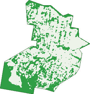
Green: 10 m cells where trees dominate, satellite 2021. Blue: water. The line is the suburb boundary.
| Canopy share, 1 m canopy height map, 2020 | 20.0% |
|---|---|
| Land with trees, 10 m satellite map, 2021 | 35.4% |
Demographics
Unemployment 4.2% · Labour-force participation 67.6%
Population by age in Mitchelton
| 0-4 | 631 |
|---|---|
| 5-14 | 1,241 |
| 15-19 | 544 |
| 20-24 | 551 |
| 25-34 | 1,290 |
| 35-44 | 1,480 |
| 45-54 | 1,288 |
| 55-64 | 899 |
| 65-74 | 620 |
| 75-84 | 404 |
| 85+ | 303 |
Dwelling types in Mitchelton
| House | 2,614 |
|---|---|
| Townhouse | 109 |
| Apartment | 640 |
| Other | 0 |
Households by weekly income in Mitchelton
| <$650 | 444 |
|---|---|
| $650-1,499 | 672 |
| $1,500-2,999 | 956 |
| $3,000+ | 1,127 |
Top ancestries in Mitchelton
| English | 3,685 |
|---|---|
| Australian | 3,544 |
| Irish | 1,575 |
| Scottish | 1,204 |
| Other | 870 |
| German | 584 |
Housing tenure in Mitchelton
| Owned | 807 |
|---|---|
| Mortgage | 1,225 |
| Rented | 1,248 |
| Other | 57 |
Cars per household in Mitchelton
| 0 | 263 |
|---|---|
| 1 | 1,306 |
| 2 | 1,298 |
| 3 | 331 |
| 4+ | 138 |
Commute to work in Mitchelton
| Car | 2,336 |
|---|---|
| Train | 294 |
| Bus | 32 |
| Tram/ferry | 4 |
| Walked | 88 |
| Bicycle | 57 |
| Home | 1,159 |
Top countries of birth in Mitchelton
| England | 311 |
|---|---|
| New Zealand | 201 |
| South Africa | 90 |
| India | 87 |
| United States | 58 |
| Scotland | 53 |
Languages used at home in Mitchelton
| Spanish | 71 |
|---|---|
| Mandarin | 64 |
| Japanese | 50 |
| Italian | 44 |
| French | 35 |
| German | 35 |
Birds & Wildlife Nearby
77,323 bird observations recorded near Mitchelton — most often seen:
- Noisy Miner (5,163)
- Rainbow Lorikeet (5,093)
- Torresian Crow (4,979)
- Australian Magpie (3,677)
- Laughing Kookaburra (3,625)
- Pied Currawong (3,548)
- Grey Butcherbird (3,305)
- Sulphur-crested Cockatoo (3,195)
- Australian Brush-turkey (3,166)
- Pied Butcherbird (2,747)
- Welcome Swallow (2,673)
- Blue-faced Honeyeater (2,464)
- Magpie-lark (2,395)
Show all 30 birds recorded near Mitchelton
- Scaly-breasted Lorikeet (2,357)
- Australasian Figbird (2,346)
- Lewin's Honeyeater (2,182)
- Australian White Ibis (2,057)
- Striated Pardalote (2,008)
- Willie Wagtail (1,866)
- Eastern Whipbird (1,834)
- Crested Pigeon (1,832)
- Noisy Friarbird (1,804)
- Dusky Moorhen (1,699)
- Pacific Black Duck (1,691)
- Black-faced Cuckoo-shrike (1,689)
- Galah (1,683)
- Spangled Drongo (1,658)
- Olive-backed Oriole (1,632)
- Spotted Turtle-dove (1,613)
- Pale-headed Rosella (1,342)
Sightings reported by observers, not a survey, so the counts show what people record rather than what lives here. Source: Atlas of Living Australia.
Nearby Suburbs
The closest suburbs to Mitchelton:
- Gaythorne (1.2 km)
- Keperra (1.8 km)
- Everton Park (2 km)
- Enoggera (2.3 km)
- Everton Hills (2.4 km)
- Arana Hills (2.7 km)
- Alderley (3.3 km)
- Ferny Hills (3.6 km)
Embed this suburb
Add this free Mitchelton stat card to your own site — just copy the code:
Preview:
Cite this page
Quoting these figures? Copy the credit line:
Keep an eye on Mitchelton
One email when this data meaningfully changes — new census figures, prices, rankings. No spam, unsubscribe anytime.
Streets
- Andover Street (2)
- Balnaves Place (27)
- Belgenny Way (13)
- Benfield Street (17)
- Blackwood Street (364)
- Blaker Road (95)
- Chessom Street (53)
- Chewton Street (35)
- Church Road (141)
- Concorde Street (17)
- Constancia Street (34)
- Coorong Street (17)
- Corvi Street (12)
- Cranbrook Street (34)
- Cribb Avenue (126)
- Cross Street (24)
- Crown Street (8)
- Delvan Street (6)
- Dundal Street (2)
- Ebony Court (8)
- Echo Street (17)
- Elbury Street (45)
- Ellworthy Street (17)
- Elmstead Street (23)
- Emerald Place (16)
- Essex Street (30)
- Evergreen Street (38)
- Faucett Street (19)
- Fenwick Street (14)
- Fiat Avenue (35)
- Fida Street (19)
- Frasers Road (178)
- Gimba Street (60)
- Gizerah Street (42)
- Glen Retreat Road (83)
- Glenholm Street (157)
- Glenore Street (27)
- Grace Street (43)
- Greenview Close (9)
- Grenholm Street (1)
- Grovely Terrace (111)
- Hay Street (44)
- Hegarty Street (2)
- Heliopolis Parade (43)
- Hicks Street (25)
- Hoben Street (16)
- Hudson Avenue (32)
- Indigo Crescent (22)
- Ironbark Place (17)
- Irvine Street (37)
- Jedd Street (6)
- June Street (37)
- Karrabin Street (15)
- Kedron Avenue (39)
- Kennion Street (18)
- Kentville Street (50)
- Keylar Street (63)
- Kooya Road (55)
- Kumbari Crescent (54)
- Kunkala Street (1)
- Kyrunda Street (19)
- Lansvale Street (16)
- Lily Street (26)
- Lockrose Street (122)
- Magenta Crescent (34)
- Marshall Street (34)
- Mashobra Street (31)
- Mcconaghy Street (190)
- Meston Street (30)
- Mimosa Street (10)
- Morningvale Place (22)
- Naturesque Close (10)
- Nicholson Street (73)
- Northmore Street (38)
- Osborne Road (623)
- Parkview Street (44)
- Parnoo Street (13)
- Pascoe Street (103)
- Pibbin Close (6)
- Princess Street (38)
- Prospect Road (3)
- Railway Parade (23)
- Rolleston Street (17)
- Ruby Road (27)
- Saint Helens Road (63)
- Samford Road (200)
- Scanlan Road (39)
- Serenity Court (5)
- Skyring Street (1)
- Station View Street (30)
- Suez Street (45)
- Sussex Street (14)
- Taltarni Circuit (47)
- Taylors Road (1)
- Tel El Kebir Street (18)
- Tel-el-kebir Street (21)
- Thagoona Street (2)
- Towns Street (41)
- Tranquillity Circuit (8)
- Tuggan Street (11)
- Turnbull Street (13)
- Union Street (29)
- University Road (128)
- Vernor Street (3)
- Vorneen Lane (7)
- Wanora Street (2)
- Wigan Street (24)
- Willcocks Street (15)
- Woking Street (29)
- Woodhaven Place (24)
- Wye Street (18)
- Zeitoun Street (21)